Single frequency high precision positioning method based on GNSS

A positioning method and high-precision technology, applied in the field of navigation, can solve problems such as limited applications and poor positioning accuracy

Active Publication Date: 2017-04-19
BEIHANG UNIV
View PDF4 Cites 42 Cited by
  • Summary
  • Abstract
  • Description
  • Claims
  • Application Information

AI Technical Summary

Problems solved by technology

However, its positioning accuracy is poorer than that of dual-frequency GPS, which limits its application in high-precision scenarios

Method used


Image

  • Single frequency high precision positioning method based on GNSS
  • Single frequency high precision positioning method based on GNSS
  • Single frequency high precision positioning method based on GNSS

Examples


Embodiment Construction

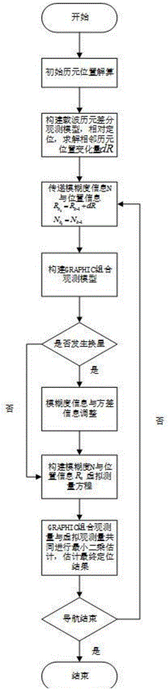
[0169] The following will combine figure 1 and the technical solution further describe the specific implementation process of the present invention in detail.

[0170] A kind of single-frequency high-precision positioning method based on GNSS of the present invention, see figure 1 As shown, the steps are as follows:

[0171] Step 1: Initial epoch position calculation

[0172] Construct the theoretical value Z of GRAPHIC combined observations.

[0173] From the formula (4), it can be seen that the GRAPHIC combined observation equation is a state variable x=(x r ,yr,z r ,δt r ,N 1 …N p ) T The nonlinear equation of , where the ambiguity subscript represents the total number of GPS satellites observed in the current epoch. The calculated value Z of GRAPHIC combined observations is calculated as follows:

[0174]

[0175] where ρ 0 The relationship is as follows:

[0176]

[0177] Among them, the symbol "~" in the above formula indicates the estimated value, ar...


PUM


Abstract

The invention relates to a single frequency high precision positioning method based on GNSS. The method comprises steps that 1, preparation work is carried out; 2, initial epoch position solution is carried out; 3, a carrier wave phase epoch difference observation model is constructed, and a relative position variance is solved; 4, the fuzziness information and the position information are transmitted; 5, the fuzziness information and the variance information are adjusted; 6, a fuzziness and position information virtual observation equation is constructed; and 7, least square estimation for a GRAPHIC combined observation equation and a virtual observation equation is commonly carried out, and a final positioning result is solved. Through the method, a GRAPHIC combined kinetics positioning algorithm aided by carrier wave phase epoch difference is utilized, kinetics navigation positioning precision is improved, precise ephemeris energy is employed to carry out high precise orbit determination for LEO satellites, and broadcast ephemeris energy is employed to realize real-time navigation positioning. The method is advantaged in that the method is not influenced by satellite change in a navigation positioning process, high reliability, low cost and simple data processing are realized, and the method is suitable for popularization and application.

Description

technical field [0001] The invention provides a high-precision single-frequency positioning method based on GNSS (Global Navigation Satellite System), which relates to a method for calculating the absolute position of an aircraft, ground, or sea surface moving carrier using GNSS, and belongs to the field of navigation technology. Background technique [0002] Global Positioning System (GPS, Global Positioning System) is a satellite navigation system established by the United States, which can provide users with real-time three-dimensional navigation services. With the wide application of GPS, many scientific research institutions have begun to pay attention to the application of its single receiver in the precise orbit determination of low-orbit satellites, as well as the high-precision positioning of ground and sea, stationary or moving carriers. At present, the above research can be divided into two directions. First, the precise positioning of dual-frequency GPS is used;...

Claims


Application Information

Patent Timeline
Patent Type & Authority Applications(China)
IPC IPC(8): G01S19/44
CPCG01S19/44
Inventor 陈培张键孙秀聪魏华波
Owner BEIHANG UNIV
Why Eureka
Try Eureka