Three-dimensional point cloud data acquisition device and three-dimensional point cloud data acquisition method by means of two-dimensional laser scanner

A two-dimensional laser and laser scanning technology, used in measuring devices, using re-radiation, instruments, etc., can solve the problem of large volume, no introduction of the coordinate transformation method of laser point cloud data 2D to 3D, and the price of three-dimensional laser scanners is expensive. and other problems, to achieve the effect of synchronous acquisition and positioning, and light size

Active Publication Date: 2017-04-26
广东广量测绘信息技术有限公司
View PDF4 Cites 18 Cited by
  • Summary
  • Abstract
  • Description
  • Claims
  • Application Information

AI Technical Summary

Problems solved by technology

[0002] 3D laser scanners can obtain data information in the entire 3D space, but 3D laser scanners are generally expensive and relatively large in size
However, none of their literatures introduced the 2D to 3D coordinate transformation method of laser point cloud data before registration and composition.

Method used


Image

  • Three-dimensional point cloud data acquisition device and three-dimensional point cloud data acquisition method by means of two-dimensional laser scanner
  • Three-dimensional point cloud data acquisition device and three-dimensional point cloud data acquisition method by means of two-dimensional laser scanner
  • Three-dimensional point cloud data acquisition device and three-dimensional point cloud data acquisition method by means of two-dimensional laser scanner

Examples


Embodiment Construction

[0040] The present invention will be further described below in conjunction with the embodiments and the accompanying drawings.

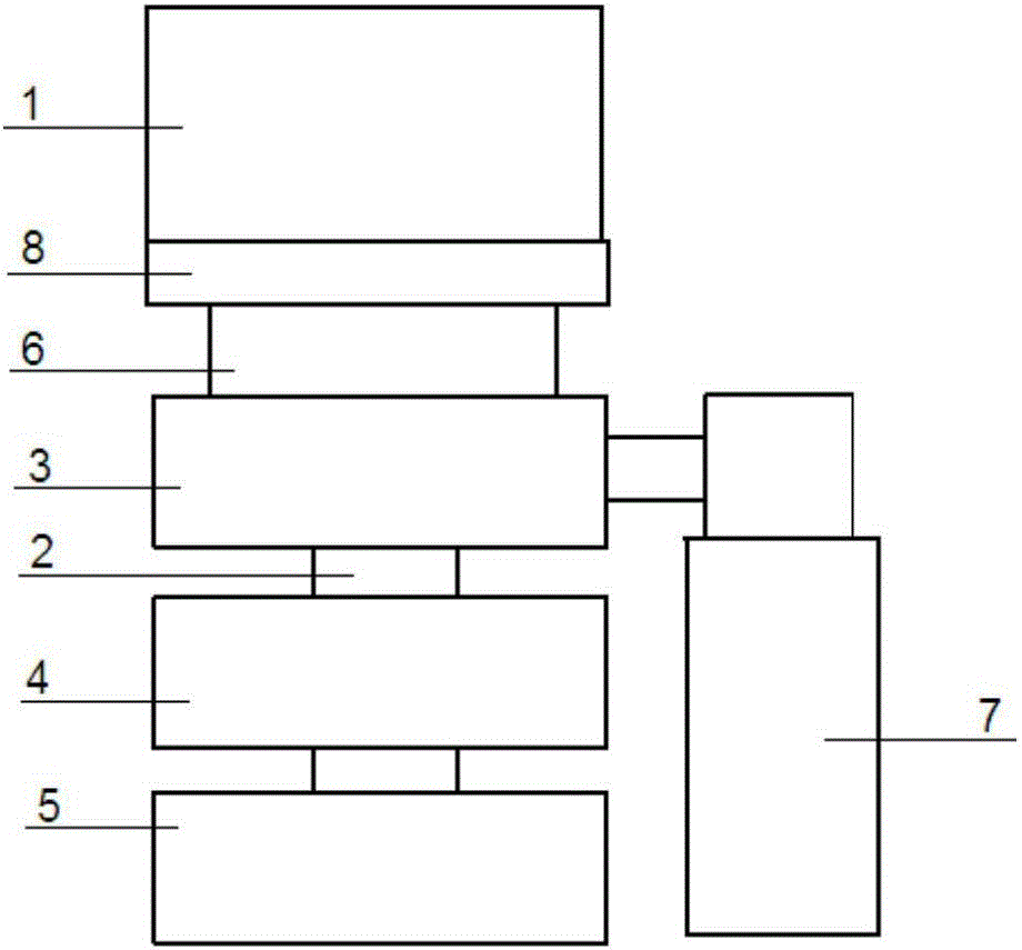
[0041] 1, mechanical principle of the present invention:

[0042] The laser scanner used in this embodiment is the 30LX laser radar of HOKUYO Company, which can realize two-dimensional 270° plane scanning and detect obstacles up to 30m away. The pulsed laser is emitted in all directions in the plane by rotating the mirror and the reflected light is received by the laser receiver. The distance between the obstacle and the radar is measured by calculating the time difference between reflection and reception. In this way, the information of one or more points of the obstacle in the scanning plane is obtained. Using this information, the distance (depth) and width information of obstacles can be obtained, but without knowing the height information, it is impossible to accurately identify obstacles and perceive the three-dimensional environment.

[004...


PUM


Abstract

The invention discloses a three-dimensional point cloud data acquisition device and a three-dimensional point cloud data acquisition method by means of a two-dimensional laser scanner, wherein a coordinate conversion method of laser point cloud data from two-dimensional data to three-dimensional data is presented. Influences of factors such as sensor working mode difference and hardware process level to a conversion process are analyzed, and furthermore a corresponding settlement method is presented. The settlement method comprises the steps of approximating true speed of a turntable through Kalman filtering; correcting serial-port data acquisition time; compensating an angle change amount of a laser point in one period; and calculating angle deviation and position deviation of the laser scanner in a horizontal axis and a longitudinal axis. Experiments represent a fact that a spatial three-dimensional point cloud structure can be accurately acquired in static three-dimensional laser scanning by means of a rotating platform. In moving scanning, because of relatively small size, the position of a moving platform can be obtained through data registration in acquiring the three-dimensional data, thereby realizing synchronous map acquisition and positioning.

Description

technical field [0001] The invention relates to the technical field of 3D mapping realized by a 2D laser ranging sensor, in particular to a device and method for acquiring 3D point cloud data using a 2D laser scanner. Background technique [0002] Three-dimensional laser scanners can obtain data information in the entire three-dimensional space. However, three-dimensional laser scanners are generally expensive and relatively large in size. Such as velodyne HDL-64E (priced at about 300,000 RMB), ibeo Scala laser (priced at about 200,000 RMB). [0003] When performing 3D laser scanning, it is often a "stop and go" type of scanning and must be scanned at a pre-set location. However, in some special environments, such as mines or caves, more convenient and smart hand-held laser mapping equipment is often required [1-2]. The realization of 3D mapping based on 2D laser ranging sensor is a low-cost 3D mapping solution, and it is also the best solution that can realize 360-degree ...

Claims


Application Information

Patent Timeline
Patent Type & Authority Applications(China)
IPC IPC(8): G01S17/89G01S7/481G01S7/48
CPCG01S7/4802G01S7/4817G01S17/89
Inventor 李昕吕婧王坚李增科张爱娟赵智博
Owner 广东广量测绘信息技术有限公司
Why Eureka
Try Eureka