Miniaturized unmanned aerial vehicle positioning and navigation method based on Beidou navigation system

A Beidou navigation system, unmanned aerial vehicle technology, applied in the field of unmanned aerial vehicle and flight control, can solve the problems of lost positioning, low accuracy, low positioning reliability, etc.

Inactive Publication Date: 2017-05-10
TIANJIN UNIV
View PDF4 Cites 15 Cited by
  • Summary
  • Abstract
  • Description
  • Claims
  • Application Information

AI Technical Summary

Problems solved by technology

[0008] In addition to the lack of accuracy, due to the limited number of satellites in orbit of the Beidou navigation system in practical applications, the positioning reliability is low, and the positioning is often lost due to occlusion.
For the traditional system ...

Method used


Image

  • Miniaturized unmanned aerial vehicle positioning and navigation method based on Beidou navigation system
  • Miniaturized unmanned aerial vehicle positioning and navigation method based on Beidou navigation system
  • Miniaturized unmanned aerial vehicle positioning and navigation method based on Beidou navigation system

Examples


Embodiment Construction

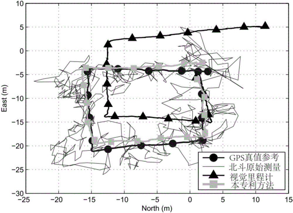
[0069] The technical problem to be solved by the present invention is to provide an autonomous positioning method for unmanned aerial vehicles based on the fusion of Beidou satellite navigation system and visual sensor data, so as to realize accurate and drift-free positioning of unmanned aerial vehicles in outdoor environments.

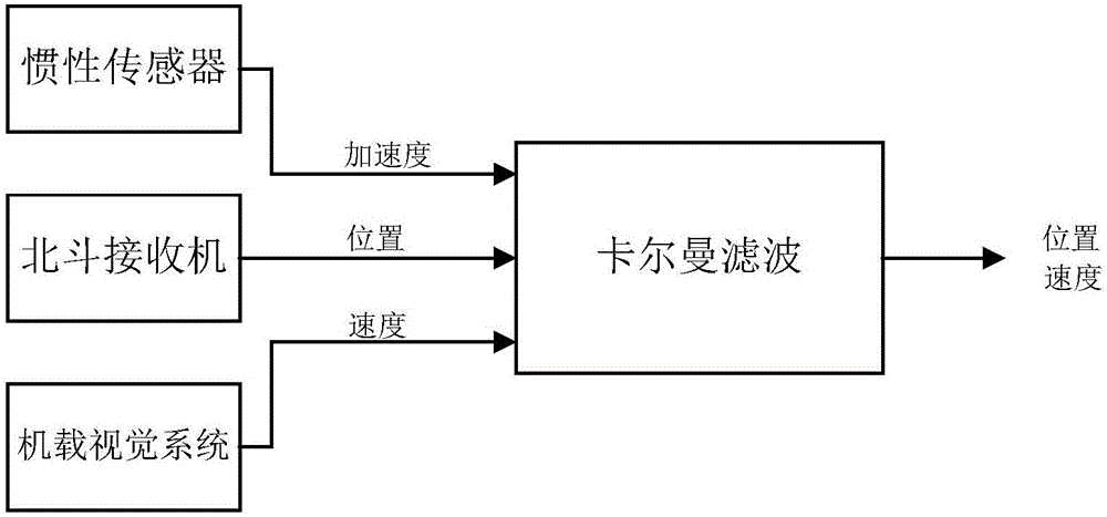
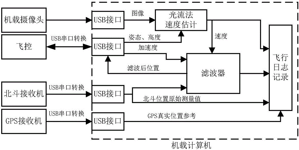
[0070] The technical scheme adopted in the present invention is: adopt the method of data fusion of the Beidou satellite navigation system and the optical flow sensor to be used in the positioning system of the unmanned aerial vehicle, comprising the following steps:

[0071] The present invention adopts a "sensor fusion (filtering)-control" framework, and integrates Beidou, optical flow, and inertial navigation through a filter, and realizes flight control accuracy that cannot be achieved by a single Beidou navigation system. In addition, a new nonlinear robust controller based on the robust integral of the sign of error (Rotust Inegral of the Signum...


PUM


Abstract

The invention relates to the field of unmanned aerial vehicles and flight control and discloses a miniaturized unmanned aerial vehicle positioning and navigation method based on a Beidou navigation system. The introduction of visual navigation, the position estimation accuracy and the robustness are improved. According to the concrete technical scheme provided by the invention, the miniaturized unmanned aerial vehicle positioning and navigation method based on the Beidou navigation system comprises the following steps: obtaining speed information of an unmanned aerial vehicle by use of an optical flow sensor installed at the bottom of the quad-rotor unmanned aerial vehicle, obtaining accelerated speed information by use of an airborne inertial navigation apparatus, obtaining speed information by use of an airborne visual system, and through combination with an original measurement value of the position of the Beidou system, obtaining estimation of the position and the speed through fusion filtering; and accordingly, through a nonlinear position control algorithm, realizing aerial vehicle position control. The method is mainly applied to unmanned aerial vehicle and flight control occasions.

Description

technical field [0001] The invention relates to the fields of unmanned aerial vehicles and flight control; specifically, it relates to the positioning and navigation of multi-rotor aircraft using the Beidou satellite navigation system. Background technique [0002] With the emergence of low-cost inertial measurement systems (Inertial Navigation System, INS) and global positioning systems, the application of unmanned aerial vehicle systems is not limited to the military field, and low-cost unmanned aerial vehicles are increasingly used in civilian fields middle. Most of the current research results in the field of unmanned aerial vehicles rely on the Global Positioning System (Global Positioning System, GPS) system for positioning. However, the GPS receiver is a passive sensor, which is very vulnerable to interference or spoofing. In the inertial navigation system composed of commonly used low-cost Micro-Electro-Mechanical System (MEMS) sensors, once the GPS position informa...

Claims


Application Information

Patent Timeline
IPC IPC(8): G05D1/08G05D1/10
CPCG05D1/0825G05D1/101
Inventor 鲜斌张旭
Owner TIANJIN UNIV
Why Eureka
Try Eureka