
Conflict resolution method for performing networked GIS data production based on relational database

A conflict handling and database technology, applied in relational databases, electronic digital data processing, special data processing applications, etc., can solve problems such as inconsistent processing results, data editing conflicts, and destruction

Inactive Publication Date: 2017-05-17
WUHAN UNIV
View PDF2 Cites 7 Cited by
  • Summary
  • Abstract
  • Description
  • Claims
  • Application Information

AI Technical Summary

Problems solved by technology

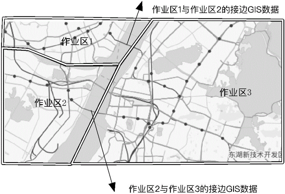
[0002] Most of the existing map data production systems based on relational databases for GIS data storage can only support single-person operations. When the workload is relatively large, multiple people are often required to participate in order to improve production efficiency. By dividing the work area In this way, the data is divided into multiple operation areas, and then each operator performs the operation separately, and finally the operation results are merged and integrated to improve production efficiency, but this method brings many bad consequences: on the one hand, due to the GIS Data usually has a strong network topology relationship, and this relationship may be destroyed when dividing the work area, making it difficult to divide the work area; Copying, in the process of splitting and copying, it is easy to cause data loss, and the quality of manual processing cannot be guaranteed; finally, when data is joined and merged, the data objects at the join may be edited by multiple operators at the same time, resulting in Inconsistencies in processing results, resulting in data editing conflicts (e.g. figure 2 , the data at the border may conflict)
[0003] When a large-scale team is working collectively, the operation object conflict caused by the joint is very frequent, which seriously affects the efficiency of the crime.

Method used


Image

  • Conflict resolution method for performing networked GIS data production based on relational database
  • Conflict resolution method for performing networked GIS data production based on relational database

Examples


Embodiment Construction

[0018] In order to facilitate those of ordinary skill in the art to understand and implement the present invention, the present invention will be described in further detail below in conjunction with the accompanying drawings and embodiments. It should be understood that the implementation examples described here are only used to illustrate and explain the present invention, and are not intended to limit this invention.

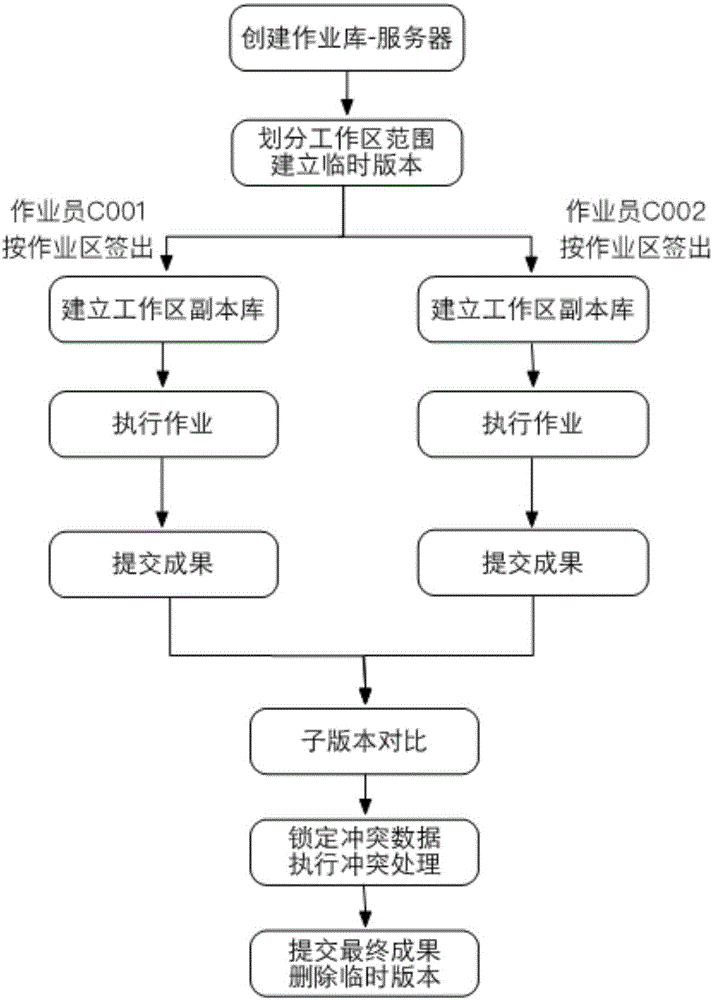
[0019] The present invention adopts the operation method of "job library server-job client": the job team leader sets up the GIS database (called "job database") to be operated on a special computer / master server (abbreviated as "data server"), Let the operator divide the operation database according to the geographic space range corresponding to the operation interval. After the division, the database corresponding to the division range becomes the "work area operation database". The operator checks in and checks out the GIS data belonging to his own operatio...


PUM


Abstract

The invention discloses a conflict resolution method for performing networked GIS data production based on a relational database. The method comprises the steps that firstly, an operation database is created; then, working area ranges are partitioned, and a temporary operation database is built for each partition; then, a working area database transcript is built, operation is executed, and a result is submitted; a main server compares signed-in data, conflict data is locked, and conflict resolution is executed; finally, the main server scans the signed-in data, and after operation results of all operators are signed in, version information of the temporary operation databases built in the partitions is deleted. According to the method, multiple persons can be allowed to operate the same GIS original data, the problem that a unified data result is formed due to the fact that multiple operators edit the same record due to map 'edge matching' is solved, and the conflict treatment problem in networked GIS data production is solved through operation area partitioning, an operation database-temporary operation library mechanism, conflict treatment operation log and edition and locking and other mechanisms.

Description

technical field [0001] The invention belongs to the technical field of GIS map data collection, processing and cartography, and in particular relates to a conflict processing method for networked GIS (Geographic Information System) data production based on a relational database. Background technique [0002] Most of the existing map data production systems based on relational databases for GIS data storage can only support single-person operations. When the workload is relatively large, multiple people are often required to participate in order to improve production efficiency. By dividing the work area In this way, the data is divided into multiple operation areas, and then each operator performs the operation separately, and finally the operation results are merged and integrated to improve production efficiency, but this method brings many bad consequences: on the one hand, due to the GIS Data usually has a strong network topology relationship, and this relationship may b...

Claims


Application Information

Patent Timeline
IPC IPC(8): G06F17/30
CPCG06F16/219G06F16/284G06F16/29
Inventor 邵世维艾廷华
Owner WUHAN UNIV
Learn More