System and method of overlaying and integrating data with geographic mapping applications

a technology of overlaying and integrating data, applied in the field of geoinformation systems, can solve the problems of delay in processing time required for uploading swf files to the client browser, limited geographic area covered, delay in request processing time, etc., and achieve the effect of high resolution vector-based imagery and comprehensive geographic breadth and detail

Inactive Publication Date: 2011-04-12
PARKER CHERYL +1
View PDF22 Cites 168 Cited by
  • Summary
  • Abstract
  • Description
  • Claims
  • Application Information

AI Technical Summary

Benefits of technology

The present invention embodiments provide several advantages including a quick request / response loop for map data retrieval, comprehensive geographic breadth and detail, high resolution vector-based imagery, utilization without a non-standard plug-in, and rendering interactive client-side polygons.

Problems solved by technology

A main problem with these types of systems includes requiring a delay in request processing time in order to upload the images.
Problems related to these types of Flash mapping systems include the limited breadth of the geographic area covered and the delay in processing time required for uploading the SWF files to the client browser.
A main problem with these types of systems includes requiring a delay in request processing time in order upload the SWF files.
A main problem of these types of systems includes the limited amount of client-side rendering performed due to client-side memory restrictions and data transfer limitations.
Accordingly, these types of systems cannot dynamically render interactive polygons (e.g., defining or representing a geographic area on the map).
Rather, the systems are limited to rendering points (e.g., representing specific locations or points of interest on a map) and lines (e.g., representing streets on a map), simple datasets and functions.
SVG (Scalable Vector Graphics) vector-based web GIS systems suffer from the disadvantage of requiring a non-standard “plug-in” download in order to use the system.

Method used


Image

  • System and method of overlaying and integrating data with geographic mapping applications
  • System and method of overlaying and integrating data with geographic mapping applications
  • System and method of overlaying and integrating data with geographic mapping applications

Examples


Embodiment Construction

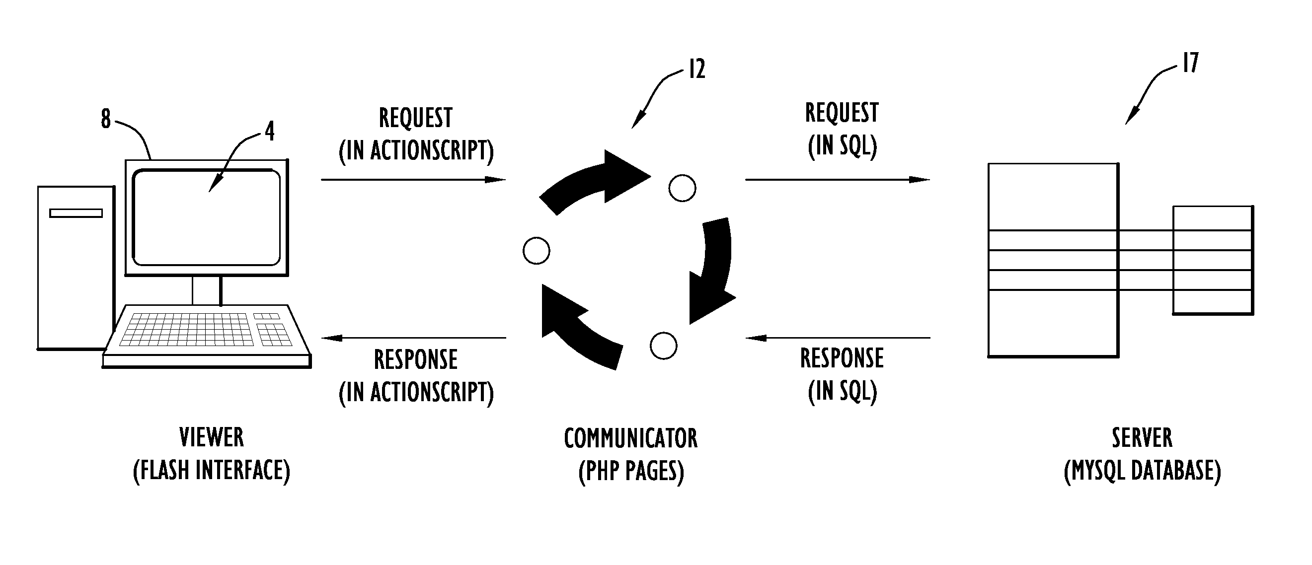
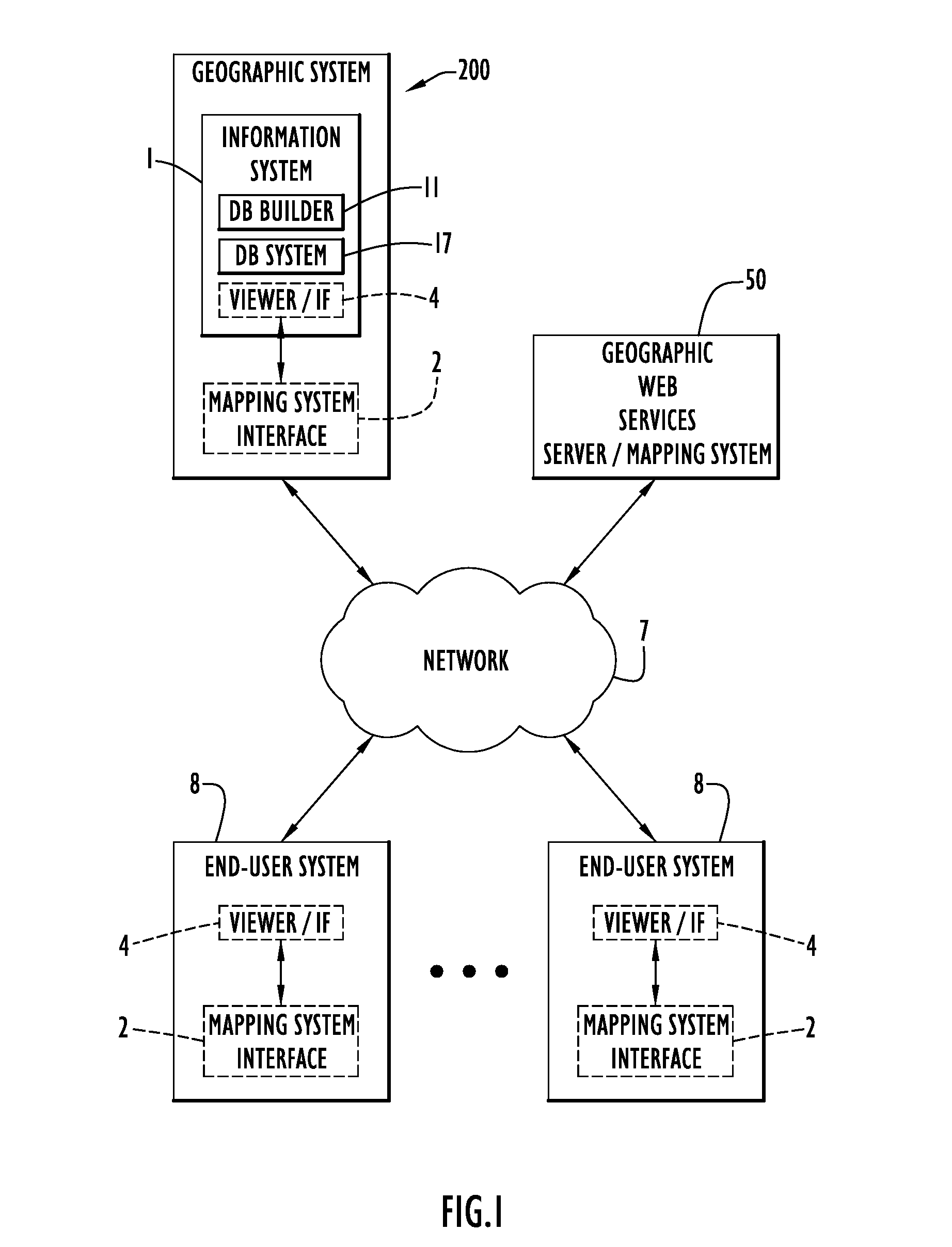
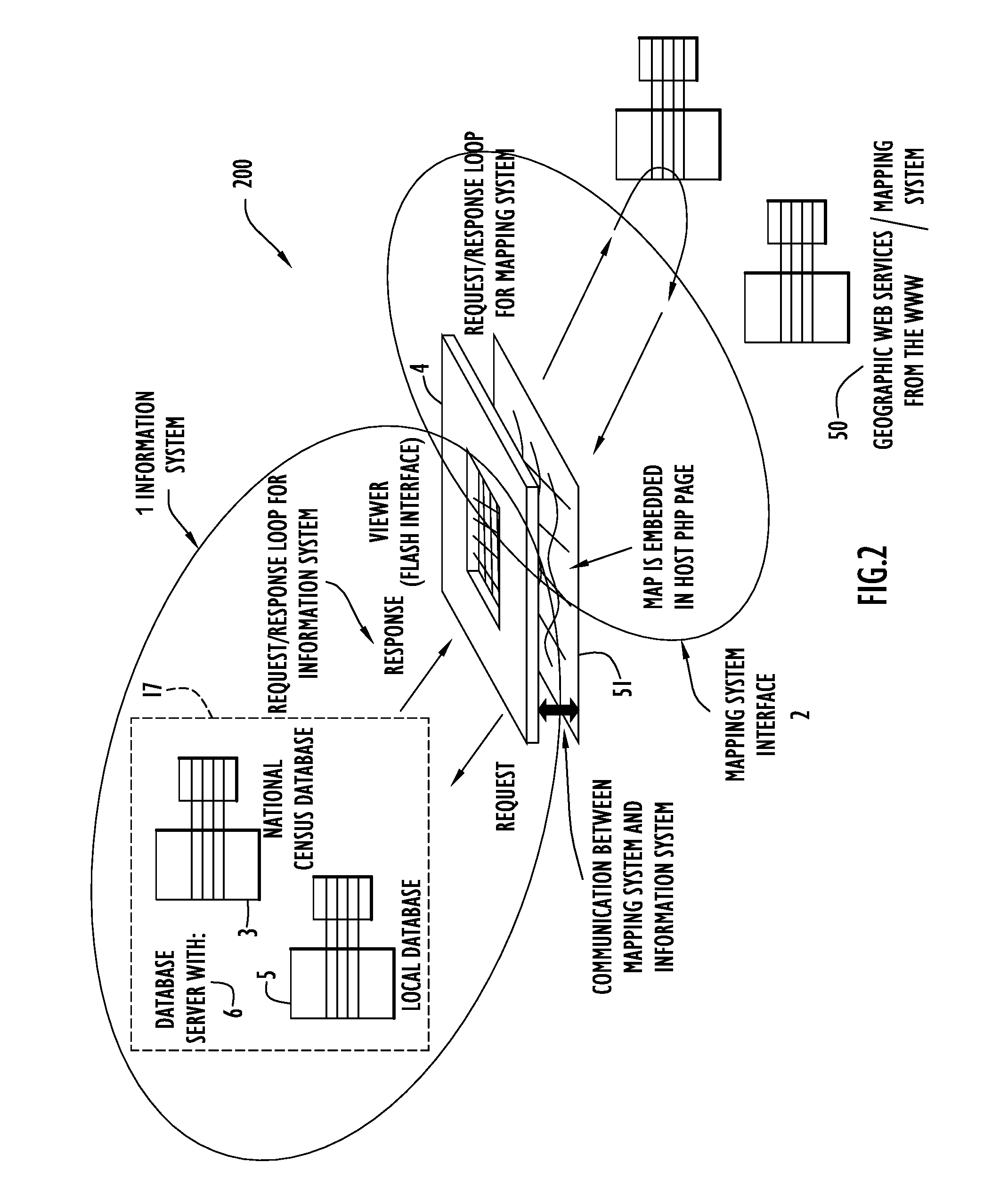
The present invention embodiments pertain to a geographic overlay system that overlays map layers onto a geographic mapping application to provide information pertaining to various locations on an underlying map. The geographic overlay system preferably utilizes geographic boundaries from National Census data to define geographic map areas and enable retrieval of corresponding information for those areas. The geographic overlay system renders points (e.g., specific locations or points of interest), lines (e.g., streets) and polygons (e.g., geographic areas, such as neighborhoods, towns, counties, etc.) within overlaying map layers to indicate corresponding locations on the underlying geographic map, and provides information associated with those locations. Thus, the geographic overlay system may enable users to draw on a map, save the boundaries, and perform a multi-layered spatial analysis that incorporates the newly drawn or generated map layer.

The geographic overlay system includ...


PUM


Abstract

The present invention embodiments include a geographic overlay system including an information system, a mapping system interface to communicate with a mapping system and a database system including National Census geographic boundaries and data files. The geographic overlay system utilizes a client / server model that streams geographic data from a server system to dynamically render vector-based map layers inside a client browser. The geographic overlay system employs a Nationwide database of Census geographies that may be rendered as interactive point, line or polygon objects over a National base map provided by the mapping system. A database builder interface enables users to build the database and server pages. The present invention embodiments overlay translucent, interactive dynamically generated vector-based polygonal Census boundary map layers over geographical maps from the mapping system. The overlaying vector map layers perform thematic analysis, enable information retrieval, display mouse-over tool-tips and query a dynamic block-level National spatial-relational database.

Description

BACKGROUND OF THE INVENTION1. Technical FieldThe present invention embodiments pertain to Geographic Information Systems (GIS). In particular, the present invention embodiments pertain to a geographic overlay system that provides a detailed geographical and data profile of a local setting.2. Discussion of the Related ArtInternet (or web) Geographic Information Systems (GIS) typically comprise a GIS database that resides on a server, a user interface on the client-side and some type of active server page that processes requests between a browser and the server. In addition, some of these systems have an administration interface to assist a System Administrator in automatically generating the web protocols for displaying the GIS database in a client browser. There are a variety of approaches for implementing web GIS. For example, a server-based Internet Map Server (IMS) web GIS system dynamically produces opaque tiled raster images on the server-side that must be uploaded to the user ...

Claims


Application Information

Patent Timeline
Patent Type & Authority Patents(United States)
IPC IPC(8): G06F3/048
CPCG06F17/30241G06F16/29
Inventor PARKER, CHERYLDIAB, YOSRI
Owner PARKER CHERYL
Why Eureka
Try Eureka