Deformation monitoring reference station based on GNSS technology, monitoring station and system thereof

A deformation monitoring and reference station technology, applied in transmission systems, measuring devices, instruments, etc., can solve problems such as weak signal, large data volume, instability, etc., to reduce network bandwidth pressure, reduce software and hardware requirements, and improve The effect of transmission stability

Active Publication Date: 2017-05-31
GUANGZHOU HI TARGET SURVEYING INSTRUMENT CO LTD
View PDF4 Cites 14 Cited by
  • Summary
  • Abstract
  • Description
  • Claims
  • Application Information

AI Technical Summary

Problems solved by technology

[0006] The existing system has the following problems: 1. Data transmission is unstable; China has a vast territory and complex terrain, and there are many places where the GPRS communication network has no signal coverage or the signal is weak or the signal is unstable; and the above-mentioned scheme adopts GPRS communication for transmission. Therefore, the GNSS raw data of some reference stations and monitoring points cannot be transmitted to the server or the data transmitted to the server is too much lost, which leads to the calculation failure of the server calculation software and the inability to obtain the location information of the monitoring points;
[0007] 2. The calculation software has a high demand for server hardware; the high-precision calculation of monitoring points in the above schemes is all on the server. If there are more than 200 monitoring points in a disaster monitoring project, the server must match a server with a level of more than 100,000. And if there are thousands of monitoring points, multiple servers must be used for distributed layout; therefore, the hardware cost of the server is high, and the more the number, the more complex the software, the greater the probability of error, and virtually buried a big hidden danger
[0008] 3. Medium and large-scale projects have high requirements on the network; because the data uploaded by each point every 15 seconds is 2KB, the data volume is large, which is not suitable for the current Internet of Things era, so medium and large-scale projects have high requirements for network bandwidth and stability. more demanding
[0009] 4. Operating costs; in the above scheme, each base station and monitoring point includes a SIM card for mobile communication, and consumes 500MB of traffic per month, which is charged by the operator, so the communication cost of data transmission is relatively high; in addition, for China Large-scale projects have higher requirements on servers, and the costs of server maintenance services, electricity charges, and project maintenance are relatively high;

Method used


Image

  • Deformation monitoring reference station based on GNSS technology, monitoring station and system thereof

Examples


Embodiment Construction

[0024] The present application is further described in conjunction with the following examples.

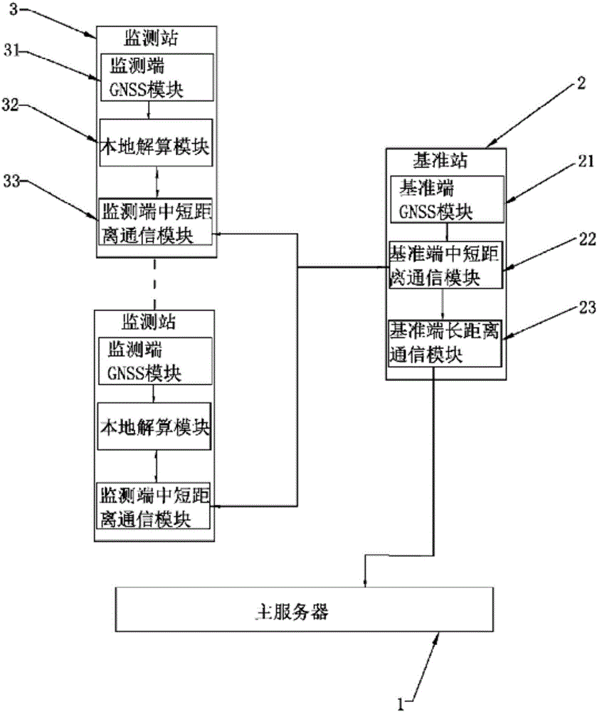
[0025] For the specific implementation of the deformation monitoring system based on GNSS technology in this application, please refer to figure 1 As shown, the system includes a main server 1, and is equipped with a reference station 2 and multiple monitoring stations 3 in each detection area.

[0026] The reference station 2 is equipped with a reference end short-range communication module 22, a reference end long-distance communication module 23 and a reference end GNSS module 21 for obtaining reference end GNSS data, and the reference end short-range communication module 22 is used for monitoring terminal communication, and the reference terminal long-distance communication module 23 is used to communicate with the main server 1.

[0027] The measuring station is equipped with a short-to-medium distance communication module 33 at the monitoring end, a GNSS module 31 at the mo...


PUM


Abstract

The invention relates to the deformation monitoring technology field and especially relates to a deformation monitoring reference station based on a GNSS technology, a monitoring station and a system thereof. The deformation monitoring system comprises a main server, and one reference station and at least one monitoring station are arranged in each detection area. The reference station sends reference end GNSS data monitored by the reference station to the monitoring station via a medium-short distance communication network. The monitoring station calculates a coordinate value and / or an offset amount according to the received reference end GNSS data and monitored monitoring end GNSS data. The monitoring station of the system can communicate with the main server without through long distance communication so that transmission stability of the whole system is increased. Besides, a calculating process is distributed to each monitoring station so as to carry out processing so that software and hardware requirements of a concentrated server are greatly reduced. In addition, by using the system, a data volume transmitted by a long distance communication network with high communication cost is greatly reduced and operation cost is decreased.

Description

technical field [0001] The present application relates to the technical field of deformation monitoring, in particular to a deformation monitoring reference station, monitoring station and system based on GNSS technology. Background technique [0002] my country's geographical location is relatively special, located at the junction of the Eurasian plate and the Pacific plate, and at the northeastern boundary where the Indian Ocean plate and the Eurasian plate are squeezed and collided. The tectonic faulting activity is strong, and geological disasters of different degrees occur every year. It is one of the countries with frequent geological disasters. At the same time, with the changes in climate conditions and the intensification of human economic activities in recent years, the impact on the geological environment has been significantly enhanced, and geological disasters have become more frequent. Geological disasters not only seriously threaten the life and property safet...

Claims


Application Information

Patent Timeline
Patent Type & Authority Applications(China)
IPC IPC(8): G01B21/32H04L29/08
CPCG01B21/32H04L67/12
Inventor 潘久辉林国利韩伟浩莫文晖谢广泉王玉宽
Owner GUANGZHOU HI TARGET SURVEYING INSTRUMENT CO LTD
Why Eureka
Try Eureka