Measurement method and measurement system for earth volume of road engineering

A road engineering and measurement method technology, applied in the field of surveying and mapping, can solve the problems of heavy workload, low precision, long time, etc., to achieve good mobility and achieve the effect of measurement

Inactive Publication Date: 2017-05-31
SHANGHAI HUACE NAVIGATION TECH
View PDF6 Cites 19 Cited by
  • Summary
  • Abstract
  • Description
  • Claims
  • Application Information

AI Technical Summary

Problems solved by technology

[0002] It is widely used in the inventory work of resource enterprises. At present, most of them adopt methods such as manual measurement or laser distance measurement. The workload is heavy, the time is long, the accuracy is low, and a lot of manpower and material resources are consumed.

Method used


Image

  • Measurement method and measurement system for earth volume of road engineering

Examples


Embodiment Construction

[0023] In the following description, numerous specific details are given in order to provide a more thorough understanding of the present invention. It will be apparent, however, to one skilled in the art that the present invention may be practiced without one or more of these details. In other examples, some technical features known in the art are not described in order to avoid confusion with the present invention.

[0024] In order to thoroughly understand the present invention, detailed steps and detailed structures will be provided in the following description, so as to illustrate the technical solution of the present invention. Preferred embodiments of the present invention are described in detail below, however, the present invention may have other embodiments besides these detailed descriptions.

[0025] The invention provides a method for measuring road engineering earthwork, comprising the following steps:

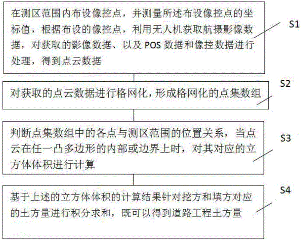
[0026] refer to figure 1 As shown, step S1: lay out imag...


PUM


Abstract

The invention provides a measurement method and a measurement system for an earth volume of road engineering. The measurement method for the earth volume of the road engineering comprises the following steps that image control points are distributed in a measurement area range; coordinate values of the distributed image control points are measured; gridding is performed on acquired point cloud data to form a gridding point set array; position relations between points in the point set array and the measurement area range are judged; when point cloud is in or on the boundary of any convex polygon, a volume of a cube corresponding to the convex polygon is calculated; and integral summation is performed on the earth volume corresponding to excavation and filling based on a calculated result of the volume of the cube to obtain the earth volume of the road engineering. According to the method and the system, the maneuverability, the flexibility and the safety are good; flight scanning measurement and imaging can be automatically performed on a surface feature to obtain high-precision point cloud and image data of an earth surface; and measurement for the earth volume of the road engineering is further realized.

Description

technical field [0001] The invention relates to the technical field of surveying and mapping, in particular to a method and system for measuring earthworks in road engineering. Background technique [0002] It is widely used in the inventory work of resource enterprises. At present, most methods such as manual measurement or laser distance measurement are used, which have a large workload, long time, low precision, and consume a lot of manpower and material resources. Every survey project is a physical and mental test for the owners and surveyors. Contents of the invention [0003] In order to solve the above-mentioned shortcomings, the present invention provides a method and system for earthwork measurement of road engineering, which has good maneuverability, flexibility and safety, and can automatically perform flight scanning measurement and imaging of ground objects to obtain ground surface High-precision point cloud and image data, so as to realize the measurement of...

Claims


Application Information

Patent Timeline
Patent Type & Authority Applications(China)
IPC IPC(8): G01C11/00
CPCG01C11/00
Inventor 何伟宋连凯汤琼陈娟赵延平
Owner SHANGHAI HUACE NAVIGATION TECH
Why Eureka
Try Eureka