Combined navigation method based on polarization information

A polarization information and integrated navigation technology, which is applied in the field of integrated navigation based on polarization information, can solve problems such as being easily interfered by signals and being easily blocked by buildings, and achieves the effect of maintaining accuracy and reducing hardware and computational complexity.

Active Publication Date: 2017-05-31
BEIHANG UNIV
View PDF3 Cites 28 Cited by
  • Summary
  • Abstract
  • Description
  • Claims
  • Application Information

AI Technical Summary

Problems solved by technology

[0002] Modern high-performance vehicles have higher and higher requirements for navigation system performance, and a single navigation system cannot meet these requirements
For example, inertial navigation has the advantages of autonomy, concealment, and the ability to obtain complete motion information of the carrier, but navigation errors accumulate over time. For low-cost micro-electromechanical inertial combinations, this defect is more obvious; GPS has high positioning accuracy and limited positioning error. However, the GPS signal is a kind of radio signal, which has disadvantages such as being easily interfered and the signal is easily blocked by buildings.

Method used


Image

  • Combined navigation method based on polarization information
  • Combined navigation method based on polarization information
  • Combined navigation method based on polarization information

Examples


Embodiment Construction

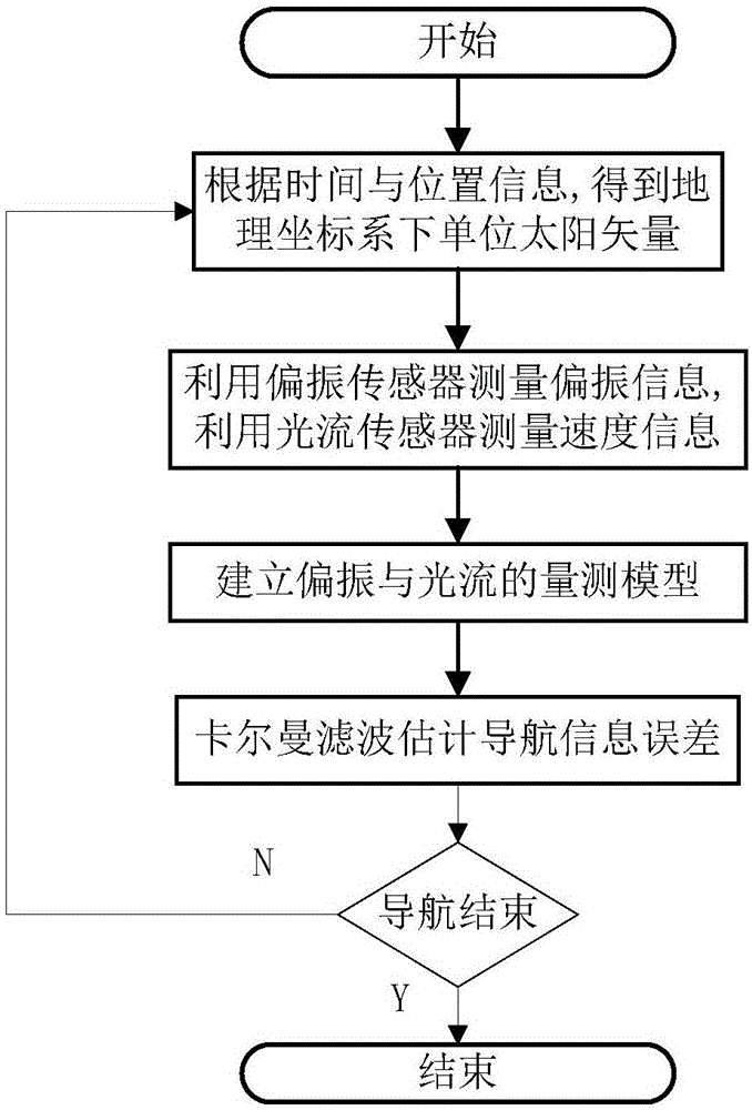
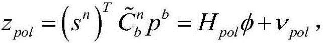
[0038] The specific embodiment of the present invention is described below in conjunction with accompanying drawing, the coordinate system that the present invention relates to mainly contains carrier coordinate system (b) and geographic coordinate system (n), polarization sensor and optical flow sensor are all fixedly connected in carrier coordinate system, polarization The sensor observes the direction of the sky, and the optical flow sensor observes the direction of the ground;

[0039] figure 1 Represented the calculation flowchart of the present invention, the concrete realization steps of the present invention are as follows:

[0040] 1. Query the astronomical almanac according to the position and time information calculated at the current moment to determine the altitude angle of the sun vector with azimuth where the sun altitude Indicates the angle between the line connecting the sun and the carrier and the local horizontal plane, azimuth Indicates the angle be...


PUM


Abstract

The invention relates to a combined navigation method based on polarization information. The combined navigation method comprises the following steps: firstly, checking astronomical ephemeris according to carrier positions and moments so as to obtain sun position information; secondly, measuring by using a polarization sensor so as to obtain polarization information, and measuring speed information by using a light stream sensor; thirdly, on the basis of polarization and light stream, establishing a filtering measuring model; and finally, estimating navigation error information by using a kalman filter. By adopting the combined navigation method, a linear measuring model based on single-polarization sensor is established, and the model is simple, small in filtering calculation amount, high in precision and applicable to autonomous navigation of the carrier for a relatively long time.

Description

technical field [0001] The invention relates to a combined navigation method based on polarization information. The equipment used includes a set of micro-electromechanical inertial combination, a polarization sensor, and an optical flow sensor. A Kalman filter is used for multi-sensor information fusion, which can be used for drones, ground Autonomous navigation of moving bodies such as robots or vehicles. Background technique [0002] Modern high-performance vehicles have higher and higher requirements on the performance of navigation systems, and a single navigation system cannot meet these requirements. For example, inertial navigation has the advantages of autonomy, concealment, and the ability to obtain complete motion information of the carrier, but navigation errors accumulate over time. For low-cost micro-electromechanical inertial combinations, this defect is more obvious; GPS has high positioning accuracy and limited positioning error. However, the GPS signal is ...

Claims


Application Information

Patent Timeline
Patent Type & Authority Applications(China)
IPC IPC(8): G01C21/00G01C21/02
CPCG01C21/005G01C21/025
Inventor 郭雷牛奔杨健王纲
Owner BEIHANG UNIV
Why Eureka
Try Eureka