Multi-information-fusion-based high precision localization method for unmanned vehicle

An unmanned vehicle and multi-information fusion technology, applied in the direction of road network navigator, etc., can solve the problems of different environmental differences and different detection ranges of sensors, so as to improve the running speed, ensure real-time requirements, and have a wide range of applications Effect

Active Publication Date: 2017-05-31
HEFEI INSTITUTES OF PHYSICAL SCIENCE - CHINESE ACAD OF SCI
View PDF6 Cites 97 Cited by
  • Summary
  • Abstract
  • Description
  • Claims
  • Application Information

AI Technical Summary

Problems solved by technology

Different sensors have different detection

Method used


Image

  • Multi-information-fusion-based high precision localization method for unmanned vehicle
  • Multi-information-fusion-based high precision localization method for unmanned vehicle
  • Multi-information-fusion-based high precision localization method for unmanned vehicle

Examples


Embodiment Construction

[0042] In order to make the object, technical solution and advantages of the present invention clearer, the present invention will be further described in detail below in conjunction with specific implementation steps and accompanying drawings. The following examples will help those skilled in the art to further understand the present invention, but do not limit the present invention in any form. It should be noted that those skilled in the art can make several modifications and improvements without departing from the concept of the present invention, and these all belong to the protection scope of the present invention.

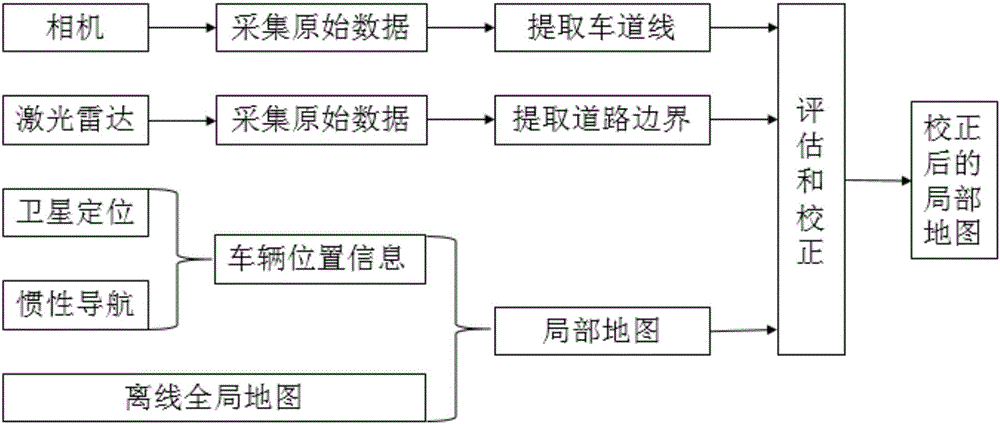
[0043] like figure 1 As shown, the present invention is based on the high-precision positioning method of multi-information fusion, comprising the following steps:

[0044] Step 1, obtain information from multiple data sources. include:

[0045] 1) The map module, combined with high-precision maps and integrated positioning systems, extracts local maps of...


PUM


Abstract

The invention relates to a multi-information-fusion-based high precision localization method for an unmanned vehicle, and the multi-information-fusion-based high precision localization method can be applied to environment perception and intelligent decision-making of the unmanned vehicle. Through cooperation of an offline map and online sensing information, high-precision real-time positioning can be realized. The offline map records road traffic information of a driving area of the unmanned vehicle. The online sensing information includes lane lines and road boundaries. When the unmanned vehicle runs in a map area, according to location information given by an inertial combined navigation system, an approximate location of the vehicle is determined, a local map near the approximate location is obtained, the lane lines in front of the vehicle and the road boundaries on both sides of the vehicle can be detected by a vehicle sensor, the relative position of the vehicle and the lane lines and the road boundaries can be determined, by contrast of the location of the vehicle in the map, deviation is calculated, a location error is corrected, and high-precision localization can be achieved.

Description

technical field [0001] The invention belongs to the technical field of unmanned vehicles, and in particular relates to a high-precision positioning method for unmanned vehicles based on multi-information fusion. Background technique [0002] An unmanned vehicle is a smart car that performs driving tasks automatically. It relies on on-board sensors to perceive the road environment, adopt appropriate driving strategies, and control the vehicle to reach the destination safely and reliably. Unmanned vehicles are highly developed products of computer science, pattern recognition and intelligent control technology, and have broad application prospects in the fields of national defense and national economy. [0003] High-precision positioning is a necessary condition for realizing unmanned driving. Using high-precision positioning and high-precision maps, unmanned vehicles can accurately determine its location, be familiar with the road traffic environment near the vehicle, and r...

Claims


Application Information

Patent Timeline
IPC IPC(8): G01C21/30
CPCG01C21/30
Inventor 王智灵崔国才金鹏黄俊杰梁华为
Owner HEFEI INSTITUTES OF PHYSICAL SCIENCE - CHINESE ACAD OF SCI
Why Eureka
Try Eureka