Temporal difference radar interference method applicable to large-gradient ground surface settlement monitoring

A technology of surface subsidence and differential interference, which is applied in measurement devices, re-radiation, radio wave measurement systems, etc., can solve the problem that TS-DInSAR is difficult to meet the needs of rapid or large gradient surface deformation monitoring, and achieve the effect of effective extraction.

Active Publication Date: 2017-05-31
SOUTHWEST PETROLEUM UNIV
View PDF4 Cites 26 Cited by
  • Summary
  • Abstract
  • Description
  • Claims
  • Application Information

AI Technical Summary

Problems solved by technology

[0004] In view of this, this application aims at the problem that TS-DInSAR is difficult to meet the needs of rapid or large-gradient surface def

Method used


Image

  • Temporal difference radar interference method applicable to large-gradient ground surface settlement monitoring
  • Temporal difference radar interference method applicable to large-gradient ground surface settlement monitoring
  • Temporal difference radar interference method applicable to large-gradient ground surface settlement monitoring

Examples


Embodiment Construction

[0029] The embodiments of the present application will be described in detail below with reference to the accompanying drawings and examples, so as to fully understand and implement the implementation process of how to apply technical means to solve technical problems and achieve technical effects in the present application.

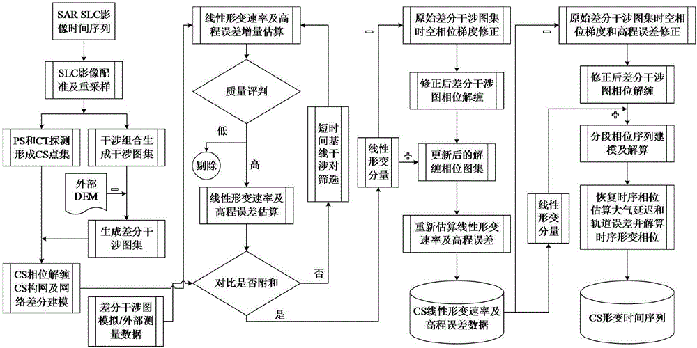
[0030] A time-series differential radar interferometry method suitable for large gradient surface subsidence monitoring, as shown in the appendix. figure 1 shown, follow the steps below:

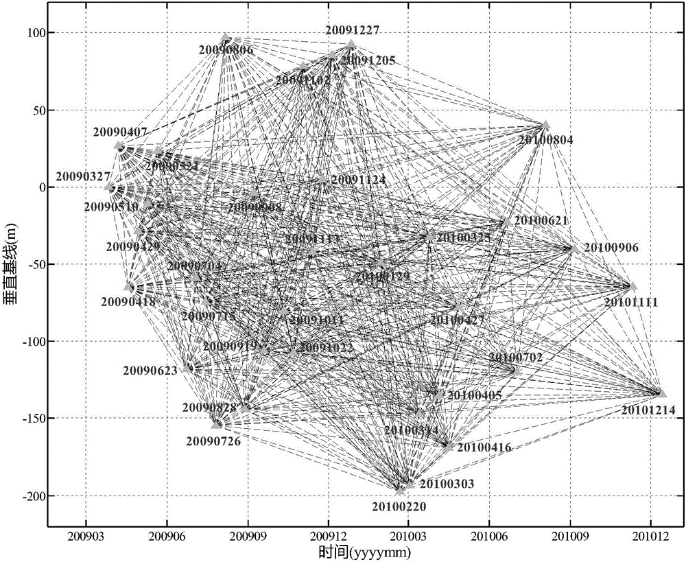
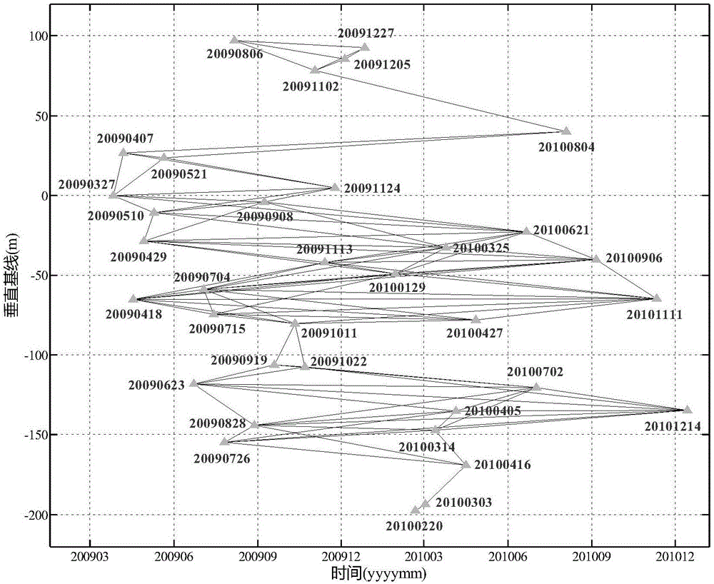
[0031] Step 1: Perform any interferometric combination on all the screened SAR images and calculate the temporal and spatial baselines;

[0032] After screening out suitable SAR images (excluding SAR images affected by weather such as rain and snow and snow cover), perform any interferometric combination pairing. Assuming that there are N+1 SAR images, N(N+1 SAR images can be formed by any interferometric combination ) / 2 interference pairs. Each interferometric pair ...


PUM


Abstract

The invention discloses a temporal difference radar interference method applicable to large-gradient ground surface settlement monitoring. According to the whole technical scheme, the method comprises the steps of short-time base line difference interference pattern screening, discrete point phase unwrapping, shape changing component modeling and calculation based on short-time base line difference interference patterns, shape changing component reliability testing, difference interference pattern phase gradient correction, iteration of the processes so as to ensure correctness of shape changing component calculation, and shape changing time sequence modeling and calculation based on corrected difference interference patterns. The problem that shape changing phase ambiguity calculation is difficult or fails due to the fact that shape changes and phase gradients are large in an original temporal difference radar interference technology is solved, finally the purpose of correctly extracting the large-gradient ground surface shape changing speed and the shape changing time sequence is achieved, the effect of decreasing the number of synthetic aperture radar images needed by large-gradient shape changing modeling and calculation is achieved, and the temporal difference radar interference application economic cost is reduced.

Description

technical field [0001] The invention belongs to the technical field of surface subsidence monitoring, and in particular relates to a time-series differential radar interference method suitable for monitoring large-gradient surface subsidence. Background technique [0002] Surface subsidence (vertical surface deformation, for ease of expression, “deformation” will be used to represent “subsidence”) is one of the most widespread geological disasters, with a long duration, and most of them occur in economically developed cities and their suburbs. It will pose lasting harm to economic development, urban construction and people's lives. my country is one of the countries with the most serious surface subsidence disasters in the world. The cumulative subsidence area of ​​more than 200 mm exceeds 150,000 square kilometers, mainly concentrated in economically developed areas such as the North China Plain, the Yangtze River Delta and the Fenwei Basin, and serious subsidence has occur...

Claims


Application Information

Patent Timeline
IPC IPC(8): G01S13/08
CPCG01S13/08
Inventor 于冰马德英肖东升杨莹辉刘福臻贾宏亮苏勇王继燕
Owner SOUTHWEST PETROLEUM UNIV
Why Eureka
Try Eureka