Visual SLAM (simultaneous localization and mapping) method based on SINS (strapdown inertial navigation system)/GPS (global positioning system) and speedometer assistance

A technology of odometer and GPS signal, which is applied in the field of automatic navigation of mobile robots, and can solve problems such as large odometer error, easy failure of GPS signal, and influence on positioning and navigation accuracy

Active Publication Date: 2017-05-31
SOUTHEAST UNIV
View PDF8 Cites 44 Cited by
  • Summary
  • Abstract
  • Description
  • Claims
  • Application Information

AI Technical Summary

Problems solved by technology

However, the GPS signal is prone to failure in an occluded environment or in an indoor environment, while the odometer has a large error and cannot adapt to more complex environments
Once a sensor fails, the accuracy of positioning and navigation will be greatly affected

Method used


Image

  • Visual SLAM (simultaneous localization and mapping) method based on SINS (strapdown inertial navigation system)/GPS (global positioning system) and speedometer assistance
  • Visual SLAM (simultaneous localization and mapping) method based on SINS (strapdown inertial navigation system)/GPS (global positioning system) and speedometer assistance
  • Visual SLAM (simultaneous localization and mapping) method based on SINS (strapdown inertial navigation system)/GPS (global positioning system) and speedometer assistance

Examples


Embodiment Construction

[0159] The present invention will be further described below in conjunction with the accompanying drawings.

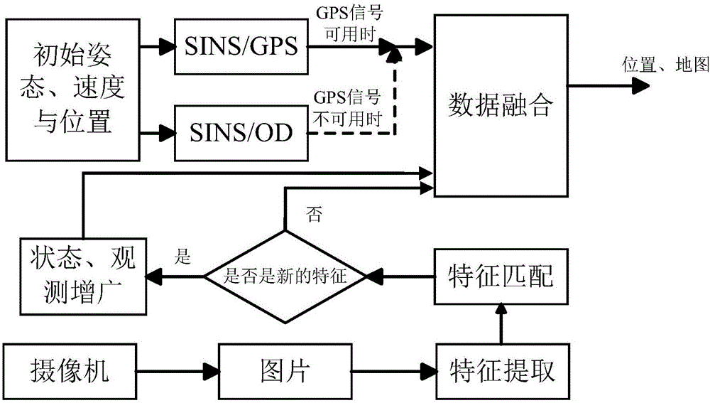
[0160] Such as figure 1 Shown is a system scheme diagram of the present invention. When the GPS signal is available, the SINS / GPS system provides a priori attitude, velocity, and position information; when the GPS signal is not available, the SINS / OD system provides a priori attitude, velocity, and position information. Among them, SINS is the strap-down inertial navigation system (Strap-down Inertial Navigation System), and OD is the odometer (Odometry). At the same time, the binocular camera takes pictures of the environment, and performs feature extraction and feature matching. Finally, the visual SLAM algorithm calculates the location information and completes the drawing.

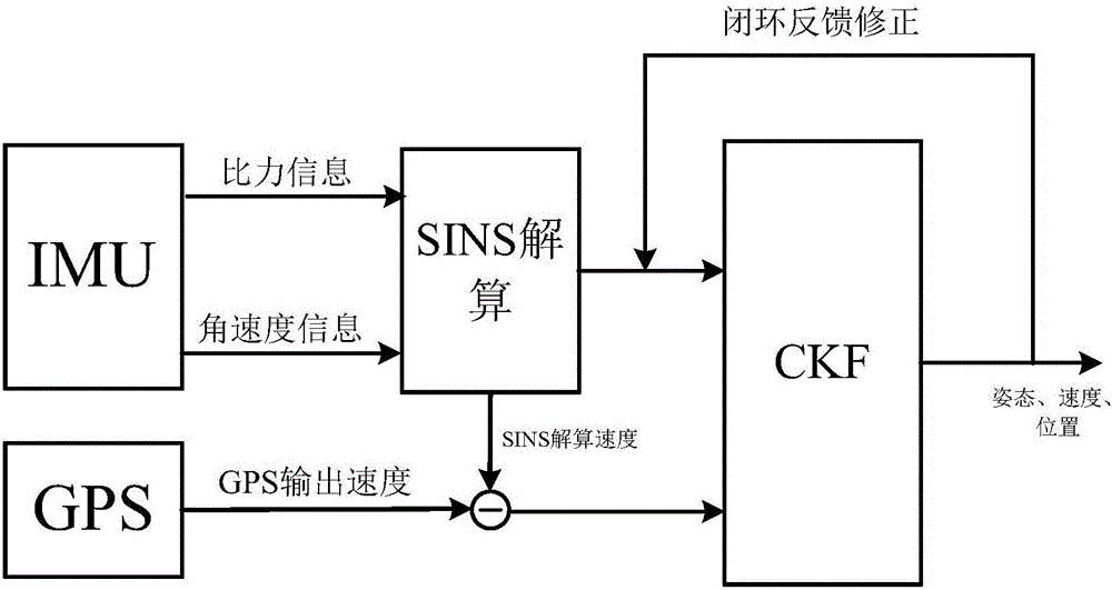
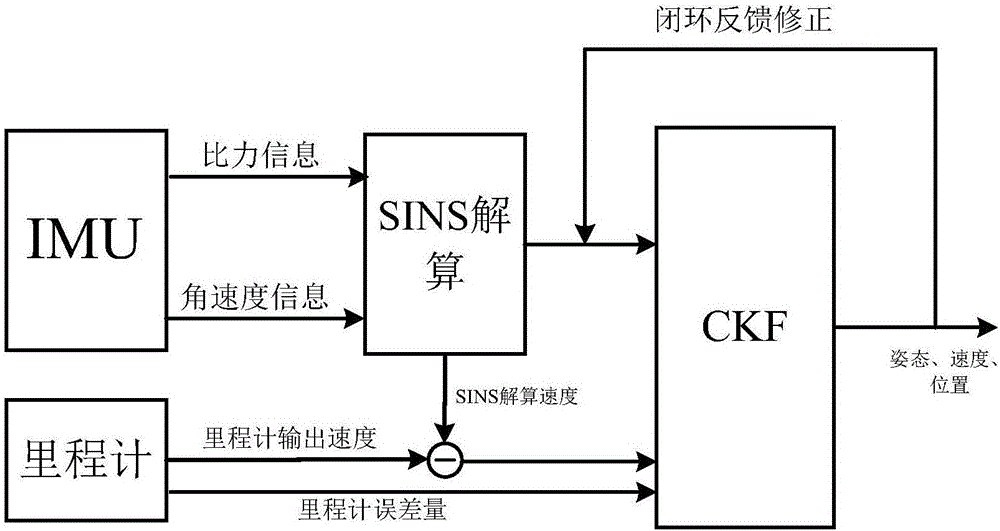
[0161] Such as figure 2 and 3 Shown is the scheme diagram of the SINS / GPS subsystem and the SINS / OD subsystem of the present invention. Both subsystems use the IMU to collect the specific ...


PUM


Abstract

The invention discloses a visual SLAM (simultaneous localization and mapping) method based on SINS (strapdown inertial navigation system) / GPS (global positioning system) and speedometer assistance. The method comprises the following steps: when GPS signals are available, performing data fusion on output information of the GPS and the SINS to obtain information including attitudes, speeds, positions and the like; when the GPS signals are unavailable, performing data fusion on output information of a speedometer and the SINS to obtain information including attitudes, speeds, positions and the like; shooting environmental images by using a binocular camera, and performing feature extraction and feature matching on the environmental images; and achieving positioning and map building by using the obtained transcendental attitude, speed and position information and environmental features, thereby completing a visual SLAM algorithm. According to the visual SLAM method disclosed by the invention, visual SLAM is assisted by using the SINA, the GPS and the speedometer, the positioning and map building under indoor and outdoor environments can be achieved, the application range is wide, and the precision and robustness of positioning can be improved.

Description

technical field [0001] The invention relates to the technical field of automatic navigation of mobile robots, in particular to a visual SLAM method based on SINS / GPS and odometer assistance. Background technique [0002] Simultaneous localization and mapping (SLAM) is one of the basic issues in the field of mobile robot research, and is the key to autonomous navigation and autonomous control of mobile robots in unknown environments. [0003] There are many ways to solve SLAM problems. With the development of visual sensors, the reduction of costs and the improvement of image processing technology, visual SLAM methods have been widely used, and visual sensors have gradually replaced other sensors. The main sensor of information. [0004] However, with the widespread application of the SLAM method, its application environment is also increasing, and a single sensor can no longer solve the SLAM problem in complex environments. Therefore, there is a multi-sensor cooperative so...

Claims


Application Information

Patent Timeline
Patent Type & Authority Applications(China)
IPC IPC(8): G06T15/00G06F17/30G01C21/32
CPCG01C21/32G06F16/29G06T15/005
Inventor 徐晓苏杨博代维
Owner SOUTHEAST UNIV
Why Eureka
Try Eureka