Management method of spatial-temporal information cloud storage

A management method and cloud storage technology, applied in the field of spatio-temporal information cloud storage management, can solve the problem of unable to meet the rapid customization needs of smart cities, data and services that cannot meet the data diversification of smart cities, automatic and intelligent services, and realization of cloud GIS platform Problems such as unsatisfactory effect

Inactive Publication Date: 2017-05-31
湖北省基础地理信息中心(湖北省北斗卫星导航应用技术研究院)
View PDF3 Cites 7 Cited by
  • Summary
  • Abstract
  • Description
  • Claims
  • Application Information

AI Technical Summary

Problems solved by technology

First of all, the support of data and services cannot meet the needs of smart cities for data diversification and automatic and intelligent services. For example, the cloud GIS platform of ArcGIS is based on the elastic cloud architecture of ArcGIS for Server, which only provides elastic deployment and service of ArcGIS Server services. monitor
Secondly, in terms of customized development, it is impossible to meet the rapid customization needs of smart cities for applications. For example, when urban emergencies (epidemics, floods, etc.) Class analysis, processing capabilities to process data, can quickly build system applications, the implementation effect of these current cloud GIS platforms is not ideal

Method used


Image

  • Management method of spatial-temporal information cloud storage
  • Management method of spatial-temporal information cloud storage
  • Management method of spatial-temporal information cloud storage

Examples


Embodiment Construction

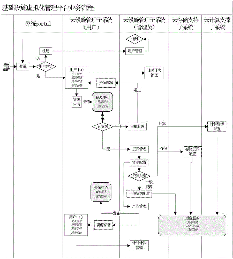
[0025] Specific embodiments of the present invention are described in detail below, which, as a part of the description, illustrate the principle of the present invention through examples, and other aspects, features and advantages of the present invention will become clear through the detailed description.

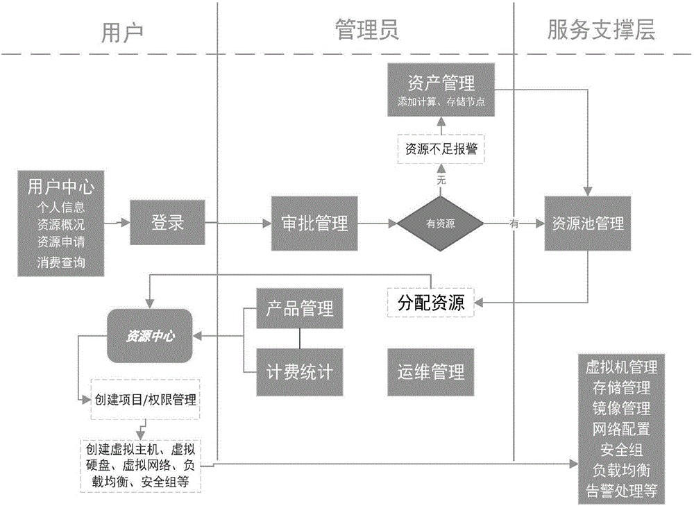
[0026] Such as Figure 1-3 As shown, it is a schematic structural diagram of the spatiotemporal information cloud storage management method of the preferred embodiment of the present invention. The spatiotemporal information cloud storage management method of the present invention includes the following steps:

[0027] Step 1: User login, the user logs into the system, and the user decides whether to register; if not registered, the user registers, and the registration information is managed by the cloud facility management subsystem, and returns to the login interface after registration, and the user logs in; if registered, enter the user center;

[0028] Step 2. View p...


PUM


Abstract

The invention discloses a management method of spatial-temporal information cloud storage. The management method combines GIS platform source in a data center and infrastructure source at the bottom layer, and realizes GIS, unification, and cloud management of the infrastructure, and provides basic hardware service, basic network service, basic software deployment service, spatial cloud calculation support service, spatial cloud storage support service and the like for a spatial-temporal information cloud platform.

Description

technical field [0001] The invention relates to a cloud storage management method for spatio-temporal information. Background technique [0002] At present, various cloud GIS platforms that have been proposed still have many defects in smart cities. First of all, the support of data and services cannot meet the needs of smart cities for data diversification and automatic and intelligent services. For example, the cloud GIS platform of ArcGIS is based on the elastic cloud architecture of ArcGIS for Server, which only provides elastic deployment and service of ArcGIS Server services. monitor. Secondly, in terms of customized development, it is impossible to meet the rapid customization needs of smart cities for applications. For example, when urban emergencies (epidemics, floods, etc.) The current cloud GIS platform does not achieve ideal results. Contents of the invention [0003] Based on the deficiencies of the above existing technologies, the technical problem solved ...

Claims


Application Information

Patent Timeline
Patent Type & Authority Applications(China)
IPC IPC(8): H04L29/08G06F17/30G06Q50/26
CPCH04L67/10H04L67/12G06F16/29G06Q50/26
Inventor 洪亮肖昶石永阁陈晓茜余晓敏段艳陈金文徐锋曹晶沈凤娇
Owner 湖北省基础地理信息中心(湖北省北斗卫星导航应用技术研究院)
Why Eureka
Try Eureka