Cultivated land requisition-compensation space auditing method and device
A technology for filling space and arable land, applied in the field of arable land resource management, can solve problems such as low efficiency and precision errors, and achieve the effect of improving audit efficiency and accuracy
- Summary
- Abstract
- Description
- Claims
- Application Information
AI Technical Summary
Problems solved by technology
Method used
Image
Examples
Embodiment 1
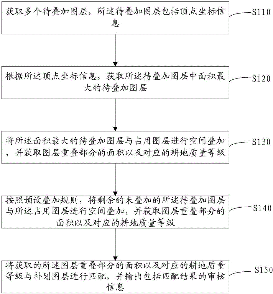
[0034] figure 2 It shows the implementation flow chart of a method for auditing cultivated land occupation and compensation space provided by the embodiment of the present invention, and is described in detail as follows:
[0035] In step S110, multiple layers to be superimposed are acquired, and the layers to be superimposed include vertex coordinate information.
[0036] In the embodiment of the present invention, the layer to be superimposed is a polygonal layer formed by scaling down the actual cultivated land according to different types of cultivated land.
[0037] In the embodiment of the present invention, the formed polygonal layer is entered into the occupied layer data and supplementary layer data in the SHP file format with a common coordinate system in the terminal, and according to the position of the layer to be superimposed, The coordinate information of each vertex of the layer to be superimposed can be read according to the coordinate system.
[0038] In s...
Embodiment 2
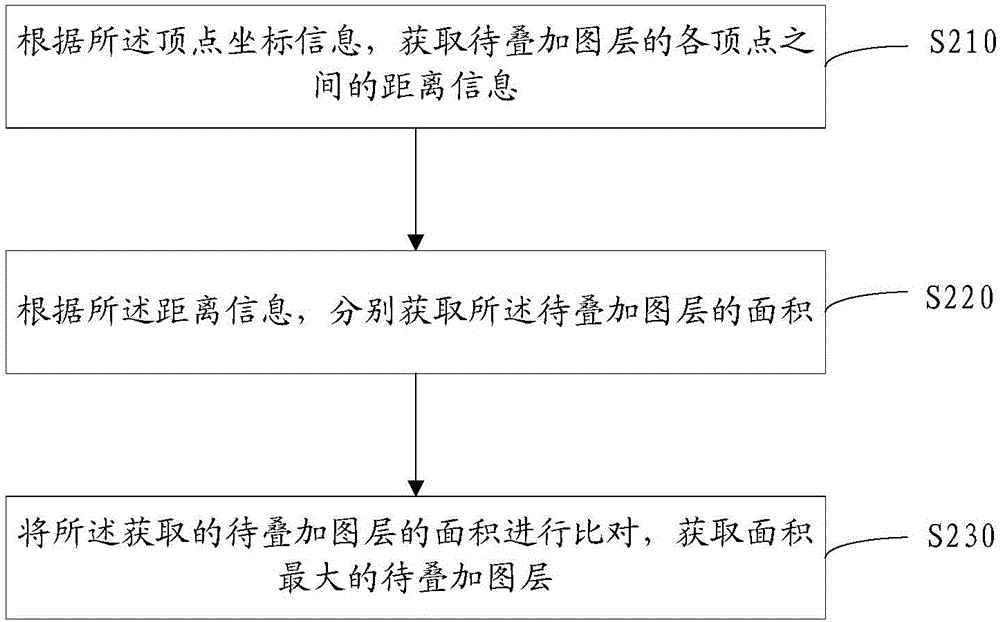
[0060] image 3 It shows the implementation process of a method for obtaining the layer to be superimposed with the largest area provided by the embodiment of the present invention, which is similar to Embodiment 1, except that the method for obtaining the layer to be superimposed is obtained according to the vertex coordinate information. The layer to be superimposed with the largest area in the layer, including:
[0061] In step S210, according to the vertex coordinate information, the distance information between vertices of the layer to be superimposed is acquired.
[0062] In the embodiment of the present invention, after importing multiple layers to be superimposed, a layer is arbitrarily selected, and the coordinate information of any two adjacent vertices in the closed polygon of the layer in the coordinate system of the current plane is read, And according to the plane coordinate information, the distance information between the two vertices is obtained according to ...
Embodiment 3
[0076] Figure 4 It shows the implementation process of another method for reviewing cultivated land occupation and replenishment space provided by the embodiment of the present invention, which is similar to the first embodiment, except that the layer to be superimposed is obtained according to the vertex coordinate information The layer to be overlaid with the largest area, and then includes:
[0077] In step S310, the layer to be superimposed with the largest area and the layers to be superimposed included in the layer to be superimposed with the largest area are generated as priority packaging layers.
[0078] In the embodiment of the present invention, after the layer to be superimposed with the largest area is obtained through the first preset algorithm and the second preset algorithm, the layer to be superimposed with the largest area and the layer to be superimposed with the largest area are The other layers to be superimposed included in the above are generated as pr...
PUM
 Abstract
Description
Claims
Application Information
 - R&D
- Intellectual Property
- Life Sciences
- Materials
- Tech Scout
- Unparalleled Data Quality
- Higher Quality Content
- 60% Fewer Hallucinations
Browse by: Latest US Patents, China's latest patents, Technical Efficacy Thesaurus, Application Domain, Technology Topic, Popular Technical Reports.
© 2025 PatSnap. All rights reserved.Legal|Privacy policy|Modern Slavery Act Transparency Statement|Sitemap|About US| Contact US: help@patsnap.com


