AUV (Autonomous Underwater Vehicle) track deviation estimation method based on multi-point terrain matching and positioning

A terrain matching and positioning error technology, applied in navigation calculation tools, navigation, surveying and mapping and navigation, etc., can solve problems such as false points, wrong positioning, and false points not mentioned in positioning

Active Publication Date: 2017-06-23
HARBIN ENG UNIV
View PDF10 Cites 16 Cited by
  • Summary
  • Abstract
  • Description
  • Claims
  • Application Information

AI Technical Summary

Problems solved by technology

[0002] The effectiveness and reliability of terrain matching positioning is the key content of terrain matching positioning and terrain matching navigation technology. For example, in the initial stage of terrain matching navigation, it is usually estimated that the navigation deviation of the navigation system is very large, so that the search interval of terrain matching positioning is very large. This situation is prone to mispositioning and false points
Moreover, the larger dead reckoning makes the convergence of the terrain matching navigation results slower, and it is easy to cause the divergence of the navigation results
At present, the commonly used terrain matching navigation method such as TERCOM method uses batch processing method to achieve positioning, b

Method used


Image

  • AUV (Autonomous Underwater Vehicle) track deviation estimation method based on multi-point terrain matching and positioning
  • AUV (Autonomous Underwater Vehicle) track deviation estimation method based on multi-point terrain matching and positioning
  • AUV (Autonomous Underwater Vehicle) track deviation estimation method based on multi-point terrain matching and positioning

Examples


Embodiment Construction

[0072] The following example further describes the main steps of the AUV track deviation estimation method based on multi-point terrain matching positioning:

[0073] Step 1: Multi-point terrain matching positioning

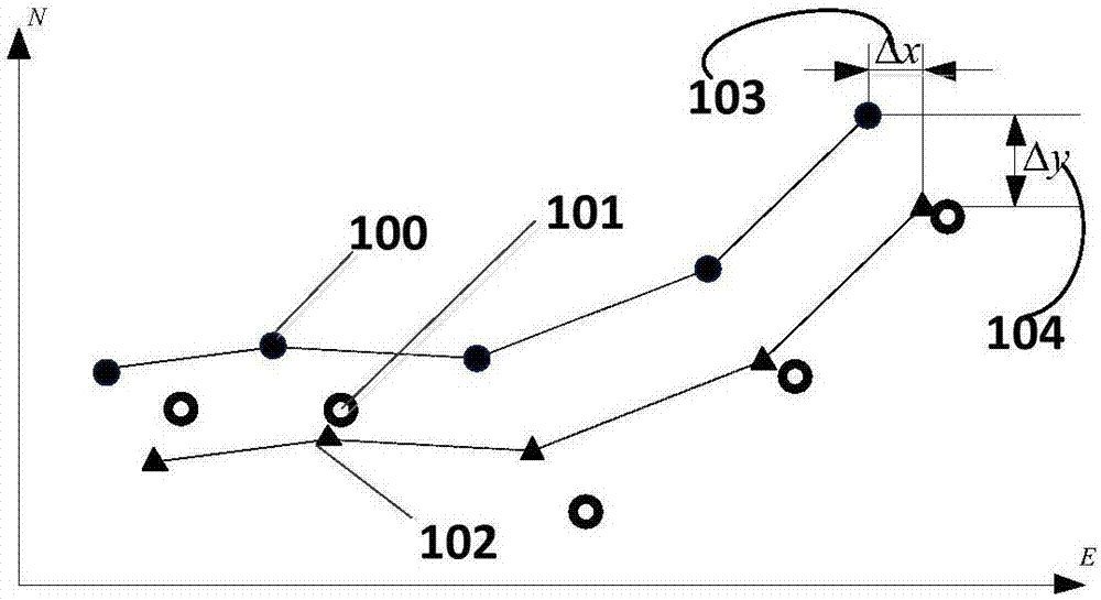
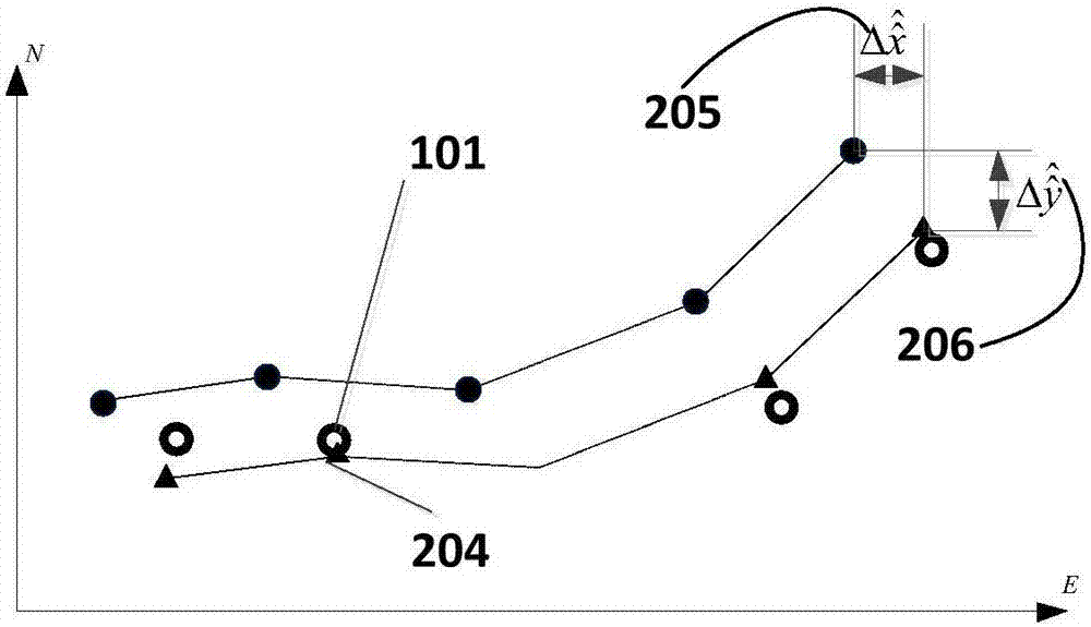
[0074] Assuming that N terrain matching positioning points are planned to correct the track deviation, and the nth terrain matching positioning point is reached at the current moment, the topographic measurement sequence Z of the current terrain matching point n , the dead reckoning position X given by the dead reckoning navigation system n =(x n ,y n ), the dead reckoning error W n =(W xn ,W yn ), the range given by dead reckoning navigation ( image 3 in step 300).

[0075] Z n Indicates the measured terrain of the nth terrain matching anchor point;

[0076] i represents the node index number in the survey terrain;

[0077] k represents the total number of nodes in the survey terrain;

[0078] Indicates the i-th terrain node in the n-th terrain s...


PUM


Abstract

The invention provides an AUV (Autonomous Underwater Vehicle) track deviation estimation method based on multi-point terrain matching and positioning. The AUV track deviation estimation method comprises the following steps: (1) estimating a searching region of the terrain matching and positioning; (2) carrying out terrain matching and positioning under unknown tidal difference and measurement error conditions; (3) estimating measurement errors and estimating a positioning confidence interval; (4) estimating positioning errors; (5) estimating multi-point terrain matching and positioning initial track deviation; (6) carrying out track correlation and eliminating an incorrect positioning point; (7) carrying out secondary fitting of a track. The AUV track deviation estimation method provided by the invention has the advantages that characteristics that reckoning navigation is slowly changed in a time domain and an airspace and a terrain matching and positioning result has no diffusivity in the time domain and the airspace are combined, and a plurality of dense terrain matching and positioning points are obtained on a track line; track line of the reckoning navigation is fitted with multi-point positioning information so that the positioning precision and the positioning reliability are greatly increased.

Description

technical field [0001] The invention relates to a terrain matching positioning method, in particular to an AUV track deviation estimation method. Background technique [0002] The effectiveness and reliability of terrain matching positioning is the key content of terrain matching positioning and terrain matching navigation technology. For example, in the initial stage of terrain matching navigation, it is usually estimated that the navigation deviation of the navigation system is very large, so that the search interval of terrain matching positioning is very large. This situation is prone to mislocation and false points. Moreover, the larger dead reckoning makes the convergence of terrain matching navigation results slower and easily leads to divergence of navigation results. At present, the commonly used terrain matching navigation method such as TERCOM method uses batch processing method to achieve positioning, but this method does not mention how to deal with the problem...

Claims


Application Information

Patent Timeline
IPC IPC(8): G01C21/20
CPCG01C21/20G01C21/203
Inventor 李晔王汝鹏姜言清马腾丛正贡雨森盛明伟张强张蔚欣何佳雨
Owner HARBIN ENG UNIV
Why Eureka
Try Eureka