Satellite positioning navigation antenna

A satellite positioning and satellite navigation technology, which is applied in the field of satellite positioning and navigation antennas, can solve problems such as narrow working bandwidth, and achieve the effect of improving gain at low elevation angles

Inactive Publication Date: 2017-08-08
BEIJING INST OF SPACECRAFT SYST ENG
View PDF3 Cites 7 Cited by
  • Summary
  • Abstract
  • Description
  • Claims
  • Application Information

AI Technical Summary

Problems solved by technology

[0002] At present, the commonly used space-borne navigation antennas in the prior art, such as single-frequency GPS four-wire helical antennas, dual-frequency GPS microstrip antennas, etc., have narrow operating bandwidths and are only suitable for receiving GPS constellation navigation signals. In order to improve the positioning accuracy and solve the problem of blind coverage of a single navigation and positioning system, the current satellite navigation system will adopt a mode compatible with multiple satellite navigation systems. Therefore, the design of the terminal antenna is an important part of the system design. determines the performance of the system

Method used


Image

  • Satellite positioning navigation antenna
  • Satellite positioning navigation antenna
  • Satellite positioning navigation antenna

Examples


Embodiment Construction

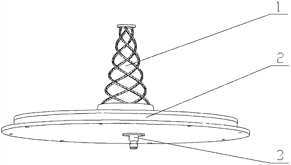
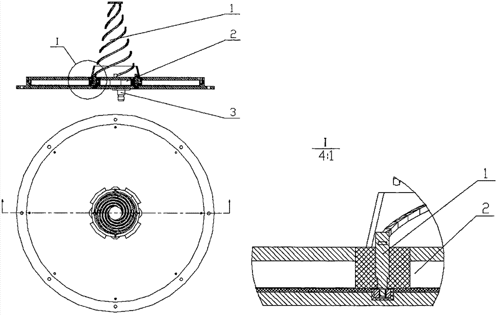
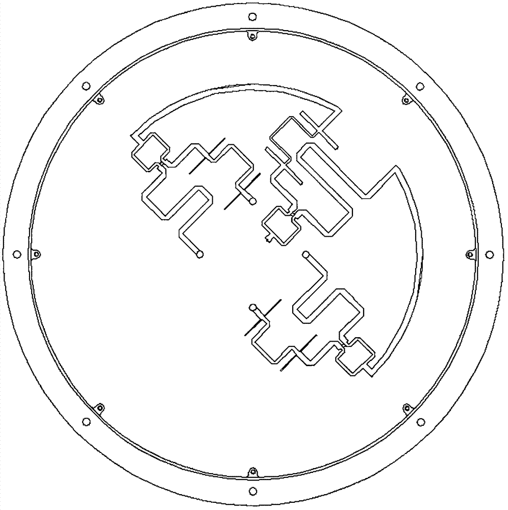
[0022] It should be understood that the satellite positioning and navigation antenna of the present invention is composed of a helical radiation body, a feeding network and a radio frequency socket. The microwave signal input port is a standard radio frequency socket commonly used in spacecraft antennas, and after the power division and phase shift of the feed network, the helical radiation body is excited to form circularly polarized radiation. The working frequency band of this antenna can cover the main navigation and positioning frequency band of 1164MHz~1615.5MHz, with a relative bandwidth of 33%. Beidou satellite navigation system), and the low elevation gain is significantly improved compared with the current conventional microstrip navigation and positioning antenna, and can be used as a satellite multi-mode broadband navigation and positioning antenna.

[0023] The present invention will be described in detail below in conjunction with the accompanying drawings and sp...


PUM


Abstract

The invention provides a satellite positioning navigation antenna, the working bandwidth of the antenna covers the main satellite navigation frequency range completely, and requirements of broadband work and high/low elevation angle gain are met. The antenna comprises a spiral radiation body, a feed network and an RF socket, the spiral radiation body is in threaded connection with the feed network, the RF socket is fastened to a base plate of the feed network, and an internal conductor of the RF socket is electrically connected with the input end of the feed network. The work frequency range of the antenna can cover the main navigation positioning frequency range from 1164MHz to 1614.5MHz, the relative bandwidth reaches 33%, the antenna is compatible with main satellite navigation positioning systems (including GPS of the USA, GLONASS of Russia, GALILEO of the EU, and Beidou of China) in the globe, compared with a routine microstrip navigation positioning antenna at present, the low elevation angle gain is improved substantially, and the antenna of the invention can serve as a multi-mode broadband navigation positioning antenna of a satellite.

Description

technical field [0001] The invention belongs to the technical field of space-borne measurement and control, and in particular relates to a satellite that can be compatible with the navigation signals of major global satellite navigation and positioning systems (for example, the GPS system of the United States, the GLONASS system of Russia, the GALILEO system of the European Union and the Beidou satellite navigation system of China). Locate the nav antenna. Background technique [0002] At present, the commonly used space-borne navigation antennas in the prior art, such as single-frequency GPS four-wire helical antennas, dual-frequency GPS microstrip antennas, etc., have narrow operating bandwidths and are only suitable for receiving GPS constellation navigation signals. In order to improve the positioning accuracy and solve the problem of blind coverage of a single navigation and positioning system, the current satellite navigation system will adopt a mode compatible with mu...

Claims


Application Information

Patent Timeline
Patent Type & Authority Applications(China)
IPC IPC(8): H01Q21/30H01Q1/38H01Q5/30
CPCH01Q21/30H01Q1/38H01Q5/30
Inventor 王晓蕾段江年杨小勇雷冀杨帆韩运忠
Owner BEIJING INST OF SPACECRAFT SYST ENG
Why Eureka
Try Eureka