Visual positioning system and method based on high-precision three-dimensional map

A three-dimensional vision and visual positioning technology, applied in satellite radio beacon positioning systems, radio wave measurement systems, measurement devices, etc., can solve the problems of high cost and low positioning accuracy, reduce positioning costs, increase hardware costs, improve The effect of precision

Active Publication Date: 2017-08-22
WUHAN UNIV OF TECH
View PDF14 Cites 29 Cited by
  • Summary
  • Abstract
  • Description
  • Claims
  • Application Information

AI Technical Summary

Problems solved by technology

[0004] The technical problem to be solved by the present invention is to provide a high-precision three-dimensional map-based visual positioning system and method ...

Method used


Image

  • Visual positioning system and method based on high-precision three-dimensional map
  • Visual positioning system and method based on high-precision three-dimensional map
  • Visual positioning system and method based on high-precision three-dimensional map

Examples


Embodiment Construction

[0037] In order to make the object, technical solution and advantages of the present invention clearer, the present invention will be further described in detail below in conjunction with the accompanying drawings and embodiments. It should be understood that the specific embodiments described here are only used to explain the present invention, not to limit the present invention.

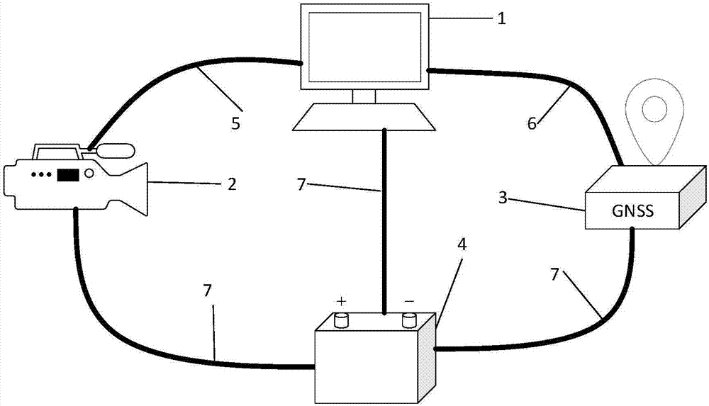
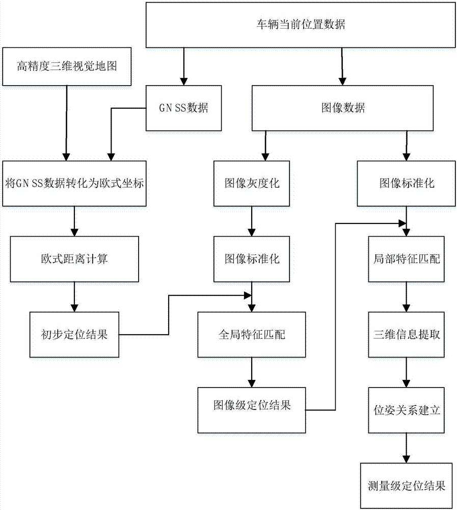
[0038] Such as figure 1 As shown, the visual positioning system based on high-precision three-dimensional map of the embodiment of the present invention includes a data acquisition module, an acquisition auxiliary module, a data processing module and a power supply module; wherein:

[0039] The data acquisition module includes a vehicle-mounted camera and a GNSS receiver, which is used to collect the image data of the current position through the vehicle-mounted camera when the vehicle travels to the position to be positioned, and obtain the corresponding GNSS data through the GNSS receiver;

[00...


PUM


Abstract

The invention discloses a visual positioning system and method based on a high-precision three-dimensional map. The system comprises a data acquisition module which is used for acquiring the image data and GNSS data of a current position, an acquisition aiding module which is used for data transmission, a power supply module which is used for supplying power to a system module, and a data processing module which is used for storing visual map information, processing the acquired GNSS data and image data and eventually realizing a positioning function, wherein the processing comprises GNSS data matching and feature point extraction and matching. The method is based on the high-precision three-dimensional map and comprises the following steps: carrying out preliminary positioning via matching of GNSS information; then carrying out image-level positioning via matching of global features; and finally carrying out measurement-level positioning and calculation via matching of three-dimensional local features so as to obtain the closest point in the map and the pose of a vehicle in the map, thereby realizing positioning of the vehicle. The system and method provided by the invention improves the precision of vehicle positioning and reduces positioning cost without great increase of hardware cost.

Description

technical field [0001] The invention relates to the field of intelligent transportation systems, in particular to a visual positioning system and method based on a high-precision three-dimensional map. Background technique [0002] High-precision vehicle positioning is the basis for automatic driving. The traditional positioning is the global satellite navigation system (GNSS), but the positioning accuracy of this system is about 10m, which is difficult to meet the high-precision positioning requirements of unmanned vehicles, which makes unmanned vehicles traveling at high speeds have potential safety hazards. To improve the positioning accuracy, most of the current high-precision positioning systems are expensive. For example, the positioning accuracy of the inertial navigation system (INS) and GNSS integrated navigation system can reach about 20cm, but the cost of the inertial navigation system is about 200,000 yuan. The above is much higher than the most common car cost ...

Claims


Application Information

Patent Timeline
IPC IPC(8): G01C21/30G01S19/48
CPCG01C21/30G01S19/48
Inventor 胡钊政陶倩文李祎承胡月志穆孟超王相龙
Owner WUHAN UNIV OF TECH
Why Eureka
Try Eureka