
Data processing method for projection deformation

A data processing and projection technology, applied in the field of data processing, can solve problems such as projection deformation, measured distance and coordinate inverse distance exceeding the specification requirements, etc., to achieve the effects of reducing impact, reducing workload, and improving work efficiency

Active Publication Date: 2017-09-15
CCCC TDC ENVIRONMENTAL PROTECTION DREDGING +2
View PDF5 Cites 8 Cited by
  • Summary
  • Abstract
  • Description
  • Claims
  • Application Information

AI Technical Summary

Problems solved by technology

[0002] In the process of checking control points before the start of large-scale projects, there is often a problem that the measured distance and the coordinate inversion distance exceed the specification requirements, which is caused by projection deformation

Method used


Image

  • Data processing method for projection deformation
  • Data processing method for projection deformation
  • Data processing method for projection deformation

Examples


Embodiment Construction

[0038] The data processing method of projection distortion of the present invention:

[0039] The first item is the deformation generated by converting the side length measured on the spot to the reference ellipsoid, that is, the elevation normalized value △S 1 ;The error equation of correction number is:

[0040]

[0041] where R A -Earth curvature radius (6371Km);

[0042] h m - the average elevation of the elevation surface where the length is located with respect to the ellipsoid;

[0043] N m - Geoid gap in the area where the ranging edge is located;

[0044] S-horizontal projection length of the ranging side on the mean elevation plane.

[0045] The second item, the length on the reference ellipsoid is projected onto the Gaussian plane, that is, the Gaussian modification value △S 2 ;The error equation of correction number is:

[0046]

[0047] where R A - radius of curvature of the earth;

[0048] Y m - the average value of the abscissa of the two ends o...


PUM


Abstract

The invention relates to a data processing method for processing data projection deformation, aiming to reduce error effectively and control the error within an effective data range. The data processing method includes the steps of 1), converting a field measurement side length into deformation generated on a reference ellipsoid surface, namely an elevation naturalization value deltaS1 so as to obtain a relation between the deltaS1 and S; 2), projecting the length on the reference ellipsoid surface to a Gauss plane, namely a Gauss deformation value deltaS2 so as to obtain a relation between the deltaS2 and S1; 3), taking S=S1 so as to obtain a relation between total length deformation deltaS and S; 4), compensating an elevation surface; 5), compensating a compensating zone applicable to the elevation.

Description

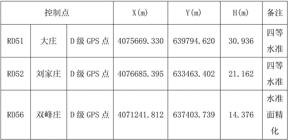
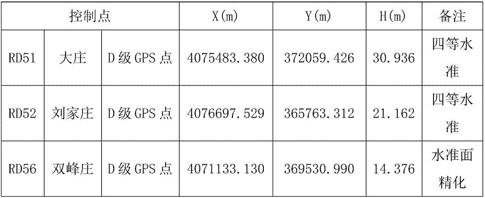
technical field [0001] The invention relates to a data processing method, in particular to a data processing method for processing data projection deformation. Background technique [0002] In the checking of control points before the start of large-scale projects, there are often problems that the measured distance and the coordinate inverse distance exceed the specification requirements, which are all caused by projection deformation. [0003] Take the geographic coordinates: 121°29′12”E, 36°47′40”N, which is now a national first-class mass fishing port as an example. If a wharf with a length of 250m is built here, the control points of the construction plane are preset, as shown in Table 1, and then three measurement control points are selected, as shown in Table 2. In order to correspond the control points to the coordinates of the design drawing, The coordinates of the control points were converted by using the conversion software, and the results are shown in Table 3....

Claims


Application Information

Patent Timeline
IPC IPC(8): G01C15/00
CPCG01C15/00
Inventor 周灼炎徐鹏远侯力杰
Owner CCCC TDC ENVIRONMENTAL PROTECTION DREDGING
Learn More