Method for city building function classification based on high-resolution remote sensing image

A remote sensing image, high-resolution technology, applied in the functional classification of high-resolution remote sensing images of urban buildings and the field of high-resolution remote sensing images, can solve problems such as difficult urban buildings, classification and identification, and achieve the effect of high classification accuracy

Active Publication Date: 2017-10-13
INST OF REMOTE SENSING & DIGITAL EARTH CHINESE ACADEMY OF SCI
View PDF10 Cites 41 Cited by
  • Summary
  • Abstract
  • Description
  • Claims
  • Application Information

AI Technical Summary

Problems solved by technology

However, only relying on the current remote sensing automatic classification and extraction technology is s

Method used


Image

  • Method for city building function classification based on high-resolution remote sensing image
  • Method for city building function classification based on high-resolution remote sensing image
  • Method for city building function classification based on high-resolution remote sensing image

Examples


Embodiment 1

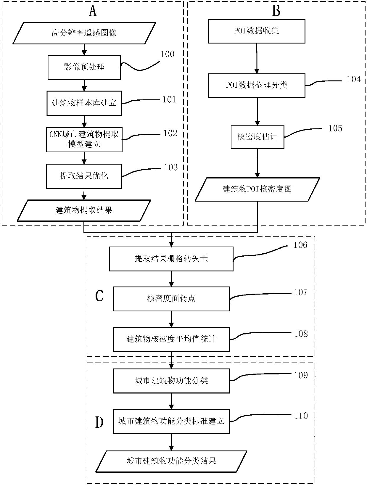
[0062] according to figure 1 It can be seen that a method for functional classification of urban buildings in high-resolution remote sensing images, the steps are:

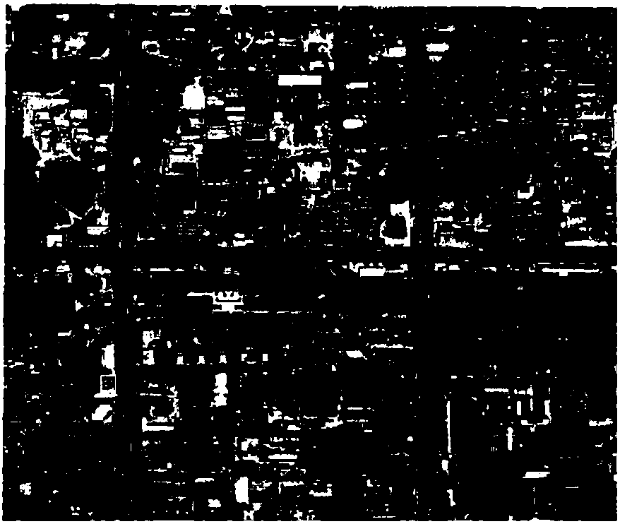
[0063] A. For a given high-resolution remote sensing image A( figure 2 ) using the CNN method to extract buildings from Quickbird multi-spectral (resolution up to 2.5m) remote sensing image data, and obtain the extraction results of buildings (such as Figure 5 ). Proceed as follows:

[0064] Preprocessing of remote sensing images 100: preprocessing of remote sensing images, including radiometric calibration, atmospheric correction, and geometric correction.

[0065] Establishment of building sample database 101: Select 80 typical building samples with high pixel purity (the number of samples used in this case) from the above remote sensing images to establish a building sample database.

[0066] Building 102 of CNN urban building extraction model: the sample bank in the building sample bank is established (...


PUM


Abstract

The invention discloses a method for city building function classification based on a high-resolution remote sensing image. The method comprises the steps of A, extracting buildings in the high-resolution remote sensing image by adopting a CNN (Convolutional Neural Network) method, and acquiring a building extraction result; B, sorting and classifying POI (Point of Interest) data according to attribute information, respectively performing kernel density estimation on POIs of the commercial and service facility land, the public management and public service land and the residential land, and respectively acquiring kernel density maps of the land types; and C, calculating a kernel density average value of the single building by using the CNN based remote sensing image building information extraction result and the kernel density maps. The method is easy to implement and simple and convenient to operate, effectively solves a problem that semantic-level building function classification and recognition are difficult to realize by using a remote sensing information extraction technology, is high in precision of function classification for the city buildings, can provide dynamic data of city functional area classification for relevant departments quickly and accurately and serves for city management and reasonable planning.

Description

technical field [0001] The invention relates to the technical field of classification and recognition of remote sensing images, and more specifically relates to a method for classifying functions of urban buildings in high-resolution remote sensing images, especially for high-resolution remote sensing images with a resolution not lower than 5m. Background technique [0002] Urban buildings are an important part of the city. As a stable space for human living and activities, their transformation and renewal always affect the development of the city and the changes in human life. According to the use function of the building, the building can be divided into various types such as commercial service facility land, public management and public service land, residential land, and industrial, mining and storage land. The functional classification of urban buildings can provide a favorable basis for the division of urban functional areas, assist government departments in the manage...

Claims


Application Information

Patent Timeline
IPC IPC(8): G06K9/00G06K9/62G06N3/08
CPCG06N3/08G06V20/176G06F18/2415
Inventor 刘亚岚曲畅任玉环
Owner INST OF REMOTE SENSING & DIGITAL EARTH CHINESE ACADEMY OF SCI
Why Eureka
Try Eureka