Method for simulating laser radar data based on multi-depth-camera splicing

A technology of depth camera and lidar, applied in the field of simulation, can solve problems such as narrow beam, high cost, and difficulty in space search targets, and achieve the effect of small data error and low cost

Inactive Publication Date: 2017-10-17
深圳市三宝创新机器人有限公司
View PDF4 Cites 7 Cited by
  • Summary
  • Abstract
  • Description
  • Claims
  • Application Information

AI Technical Summary

Problems solved by technology

The disadvantage of lidar is that it is greatly affected by the environment and climate when working, and its beam is extremely narrow, it is very difficult to search for targets in space, which directly affects the interception probability and detection efficiency of non-cooperative targets, and can only search and capture in a small range target, while its cost is very expensive, and related applications cannot be widely promoted

Method used


Image

  • Method for simulating laser radar data based on multi-depth-camera splicing
  • Method for simulating laser radar data based on multi-depth-camera splicing
  • Method for simulating laser radar data based on multi-depth-camera splicing

Examples


Embodiment Construction

[0013] The following will clearly and completely describe the technical solutions in the embodiments of the present invention with reference to the accompanying drawings in the embodiments of the present invention. Obviously, the described embodiments are only some, not all, embodiments of the present invention. Based on the embodiments of the present invention, all other embodiments obtained by persons of ordinary skill in the art without making creative efforts belong to the protection scope of the present invention.

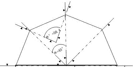
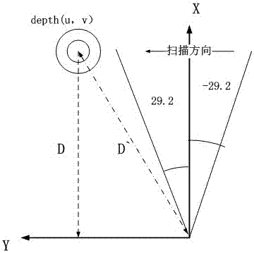
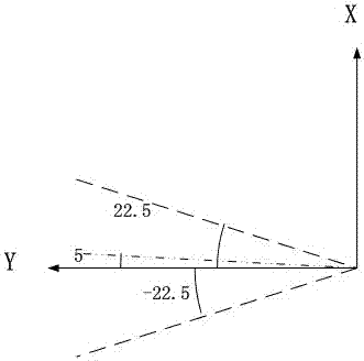
[0014] see Figure 1~4 , in an embodiment of the present invention, a method of splicing simulated lidar data based on multiple depth cameras, by combining and splicing multiple depth cameras according to specific positions, to detect obstacles greater than 90 degrees and less than 6 meters in front of the robot, Implements the operation of a simulated lidar.

[0015] Such as figure 1 Shown is the mosaic method of multiple depth cameras. Eight depth cameras ...


PUM


Abstract

The invention discloses a method for simulating laser radar data based on multi-depth-camera splicing. Through the combination and splicing of a plurality of depth cameras according to the specified positions, barriers in a range greater than 90 degrees and less than 6 meters ahead a robot can be detected, and the operation of the laser radar simulation can be realized. The data acquisition of the depth cameras is not influenced by environment, and the data error is small. The method has the advantage of low cost, and can fill the shortcomings of laser radar.

Description

technical field [0001] The invention relates to a simulation method, in particular to a method for splicing simulated lidar data based on multiple depth cameras. Background technique [0002] With the development of science and technology and the wide application of computers and high-tech, digital stereo photogrammetry has gradually developed and matured. Lidar is a radar system that works in the infrared to ultraviolet spectrum. Then compare the received signal reflected from the target with the transmitted signal, and after proper processing, the relevant information of the target can be obtained, such as target distance, azimuth, height, speed, attitude, and even shape parameters, so that Detect and identify obstacles. Depth cameras based on the three technologies of binocular, structured light and TOF (time-of-flight ranging) are also becoming more mature, which can provide depth information for smaller vision. [0003] Lidar is a radar system that emits detection sig...

Claims


Application Information

Patent Timeline
Patent Type & Authority Applications(China)
IPC IPC(8): G01S17/48
Inventor 周海明
Owner 深圳市三宝创新机器人有限公司
Why Eureka
Try Eureka