Instance-based semantic integration and multi-plan spatial data conflict detection method

A technology for spatial data and conflict detection, applied in structured data retrieval, data processing applications, electronic digital data processing, etc., can solve the problems of conflict pattern loss, land use classification conflict, non-conflict pattern mixing, etc., and achieve reliable results. , reduce the difficulty and achieve simple results

Active Publication Date: 2017-12-01
福州市勘测院有限公司
View PDF4 Cites 5 Cited by
  • Summary
  • Abstract
  • Description
  • Claims
  • Application Information

AI Technical Summary

Problems solved by technology

However, in multidimensional spatial data, the granularity and size of plots in various types of planning spatial data are not consistent, that is, there may be some plots in one type of planning spatial data, and some plots may be related to another type of planning space. The land use classification of the corresponding plots in the data is consistent, and there are conflicts between some plots and the land use classification of the corresponding plots in another type of

Method used


Image

  • Instance-based semantic integration and multi-plan spatial data conflict detection method
  • Instance-based semantic integration and multi-plan spatial data conflict detection method
  • Instance-based semantic integration and multi-plan spatial data conflict detection method

Examples


Embodiment Construction

[0021] The present invention will be described in detail below in conjunction with the drawings and implementation examples.

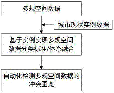
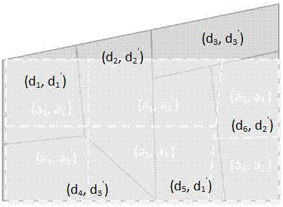
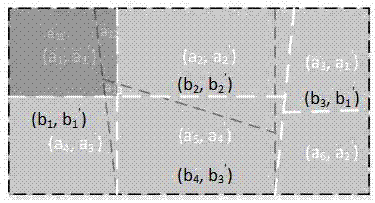
[0022] The present invention proposes an example-based semantic fusion and multi-specified spatial data conflict detection method. The method of the present invention specifically includes the following two major steps, as attached figure 1 Shown: S1 realizes the integration of multi-plan spatial data classification standards / systems based on examples; S2 automatically detects conflicting patterns of multi-plan spatial data. Suppose two planning spatial data sets are A1={a 1 ,a 2 ,...,A p } And B1 = {b 1 ,b 2 ,...,B q }, the land use classification system adopted is A'={a 1 ',a 2 ',...,A m '} and B'= {b 1 ',b 2 ',...,B n '},among them i≠j,a i ∈A1,a j ∈A1, i≠j,b i ∈B1,b j ∈B1; suppose the instance data set describing the current situation of the city is D={d 1 ,d 2 ,...,D r }, the land cover type adopted is D'={d 1 ',d 2 ',...,D r '},among them: i≠j,d i ∈...


PUM


Abstract

The invention belongs to the field of spatial data integration and plan combination and relates to an instance-based semantic integration and multi-plan spatial data conflict detection method. The method includes steps of implementation of instance-based multi-plan spatial data classification system integration and automatic detection of multi-plan spatial data conflict patches. The instance-based semantic integration method is provided to realize integration of different land planning classification systems, and then a spatial analysis method is applied to automatic detection of land plots in land classification conflict in multiple plans. The method is applicable to quick detection and discovery of difference patches among multi-plan data in 'multi-plan integration' and 'urban space planning', and multi-plan difference patch discovery efficiency is improved.

Description

Technical field [0001] The invention belongs to the technical field of combining spatial data fusion and planning, and particularly relates to an instance-based semantic fusion and multi-plan spatial data conflict detection method. Background technique [0002] Spatial data fusion is the fusion of related spatial data from different sources in the same area (Uitermark HT, and Cadastre D. The integration of geographic databases: realising geodata interoperability through the hypermap metaphor and a mediator architecture[C].Second Joint European Conference&Exhibition on Geographical Information,Barcelona,Spain.1996:92-95; Frank van Wijngaarden,Judith van Putten,Peter vanOosterom,et al.Map integration—update propagation in a multi-sourceenvironment[C].5th ACM international workshop on Advances in geographicinformation systems, LasVegas Nevada,USA:ACM,1997:71-76.), by eliminating conflicts between data and integration of information, in order to achieve data consistency, improve data...

Claims


Application Information

Patent Timeline
IPC IPC(8): G06F17/30G06Q10/06G06Q50/26
CPCG06F16/29G06Q10/0631G06Q50/26
Inventor 汪艳霞陈旭日高广亮张平高昭良黄磊
Owner 福州市勘测院有限公司
Why Eureka
Try Eureka