

A Geometric Expression Method of Projected Polar Coordinates for Moon-Based Earth Observation Images
A technology of earth observation and expression method, which is applied in the fields of surveying devices, surveying and navigation, photogrammetry/video metrology, etc. It can solve the problems of redundant observation information, sparse distribution of control points, uneven distribution, etc., and avoid space And the redundancy of information, meeting the spatial resolution requirements, and the effect of meeting the spatial resolution
Active Publication Date: 2019-10-01
INST OF REMOTE SENSING & DIGITAL EARTH CHINESE ACADEMY OF SCI
View PDF2 Cites 0 Cited by
- Summary
- Abstract
- Description
- Claims
- Application Information
AI Technical Summary
Problems solved by technology
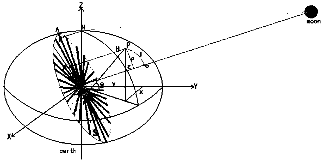
Moon-based Earth observations can continuously acquire instantaneous remote sensing images at the planetary scale. However, the geometric complexity of lunar-based observations poses a huge challenge to the geometric correction of lunar-based images. The difference in geometric deformation in different regions of the hemispherical image caused by curvature and terrain undulation, as well as the sparseness and uneven distribution of control points caused by large areas of cloud and sea coverage in the hemispherical image
In this case, directly applying the traditional geometric expression method for satellite remote sensing images to lunar-based hemispheric images will cause redundancy or lack of observation information, and seriously affect the accuracy of geometric correction
Method used
View moreImage
Smart ImageViewing Examples

Examples
Embodiment Construction
Login to View More PUM
 Abstract
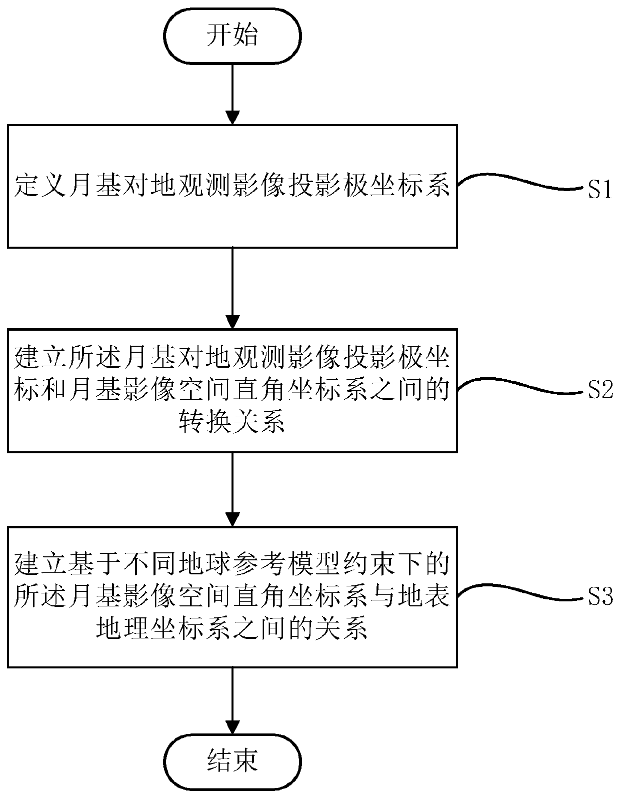
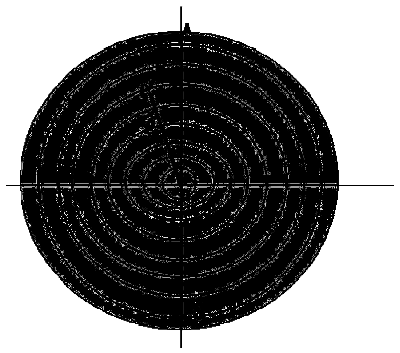
The invention provides a moon-based earth observation image oriented projected polar coordinate geometry expression method giving consideration to sublunar point movement by analyzing influencing factors of moon-earth relation and geometric distortion of moon-based images and focusing on considering influence effects of a position change of the sublunar point, earth curvature and topographic relief on large-scale hemisphere images. The method is dedicated in solving the geometric distortion problem of the hemisphere images in moon-based earth observation, the original information of the moon-based platform earth observation images can be well maintained, and accurate geocoding can be performed by utilizing a small amount of non-uniform control points.
Description
technical field The invention relates to the field of earth observation, in particular to a projection polar coordinate geometric expression method for moon-based earth observation images. Background technique At present, human beings are facing a series of unprecedented global environmental changes, which pose great challenges to human development. Therefore, the global earth observation research is getting more and more attention from all over the world. However, the current remote sensing technology based on the satellite-machine-ground platform can only conduct short-term observations of scientific phenomena in limited areas on the earth, and the repeated observation period is long. In terms of detailed and continuous observation of large-scale and dynamic issues on the earth, it is still difficult to meet the needs of global-scale observation capabilities for global change science issues. In response to this problem, Academician Guo Huadong proposed a new idea of mo...
Claims
Login to View More Application Information
Patent Timeline
 Patent Type & AuthorityPatents(China)
IPC IPC(8): G01C11/00
Inventor张露郭华东焦慧刘广李新武
OwnerINST OF REMOTE SENSING & DIGITAL EARTH CHINESE ACADEMY OF SCI