Positioning system and method for overcoming canyon effect of navigation satellite

A navigation satellite and positioning system technology, applied in the field of surveying and navigation, can solve the problem that only one or two satellites can be received and blocked, such as the road between the high-rise buildings in the city, the open space between the adjacent houses in the countryside, and the mountains and valleys. problems such as the inability of satellite positioning methods to determine receivers on river dams, and achieve the effect of effective determination

Inactive Publication Date: 2018-01-23
武汉霸云创新科技有限公司
View PDF4 Cites 14 Cited by
  • Summary
  • Abstract
  • Description
  • Claims
  • Application Information

AI Technical Summary

Problems solved by technology

However, in actual measurement, satellite signals in many locations are seriously blocked, such as roads in the cracks between high-rise buildings in cities, open spaces between adjacent houses in rural areas, river dams in alpine valleys, etc. Blocking, so that the receiver on the ground often can only receive the signal of one or two satellites, this phenomenon is called the navigation satellite canyon effect
This effect makes it impossible to use satellite positioning methods to determine the position of the receiver in the existing technology, and the aforementioned areas are often of concern to surveyors, so a positioning method that can effectively overcome the canyon effect of navigation satellites is urgently needed

Method used


Image

  • Positioning system and method for overcoming canyon effect of navigation satellite
  • Positioning system and method for overcoming canyon effect of navigation satellite

Examples


Embodiment Construction

[0033] specific implementation plan

[0034] The present invention will be described in detail below in conjunction with the accompanying drawings.

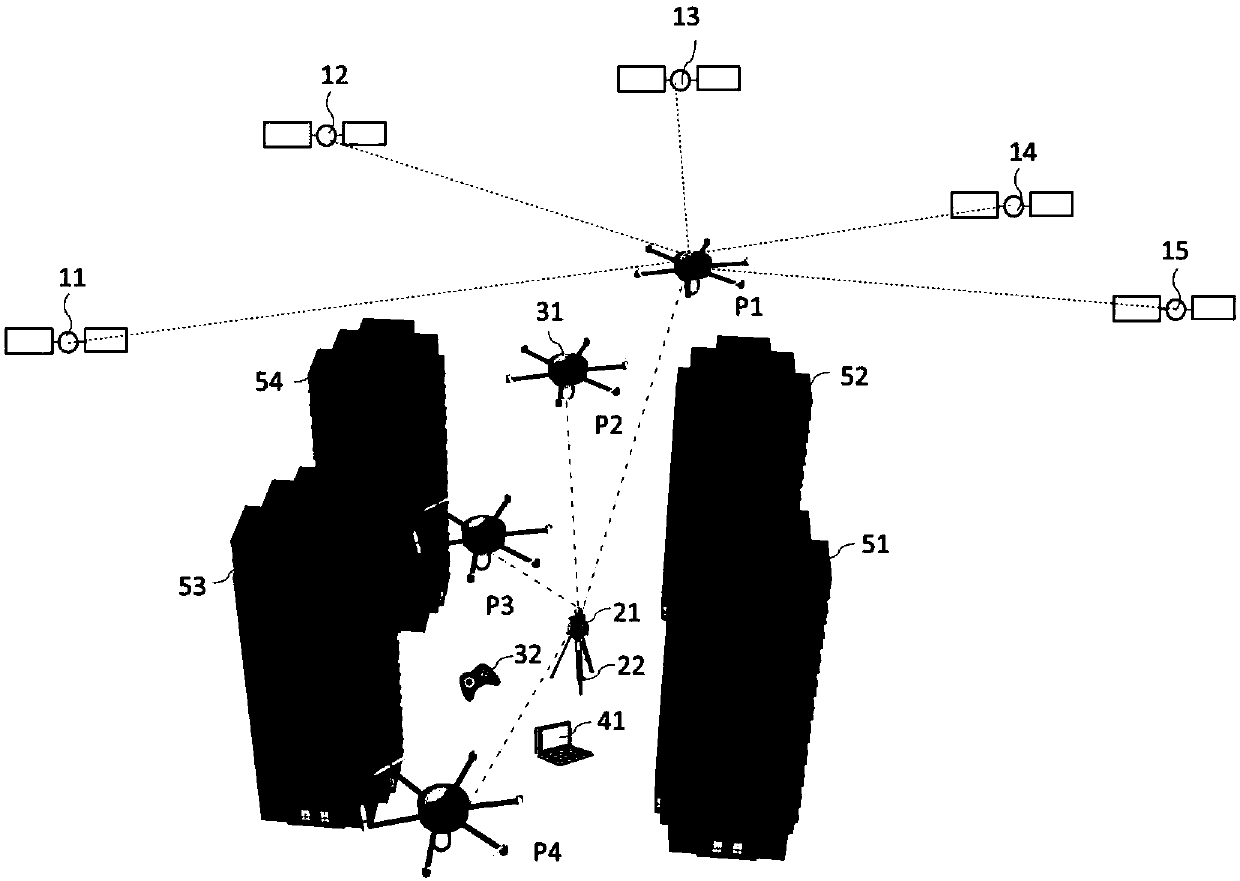
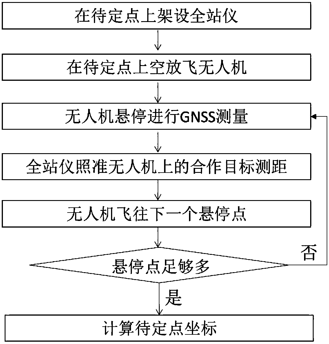
[0035] A preferred embodiment of the present invention is figure 1 As shown, the undetermined point 22 is located on the ground between a plurality of high-rise buildings 51-54. Due to the occlusion of the high-rise buildings 51-54, the undetermined point 22 can only receive signals from two satellites, the GPS satellite 12 and the GPS satellite 13. At this time, the coordinates of the point 22 to be determined cannot be accurately determined by conventional methods. To this end, this embodiment provides a system composed of a total station 21 , a drone 31 , a drone controller 32 , and a calculation unit 41 . The unmanned aerial vehicle 31 is a six-rotor type so that it can hover reliably. The drone 31 is further equipped with a GNSS module and a reflector, wherein the antenna part of the GNSS module is located on the top of t...


PUM


Abstract

The invention provides a positioning system and method for overcoming a canyon effect of a navigation satellite. A GNSS module and a laser cooperation target are mounted on an unmanned aerial vehicle(UAV), the UAV is controlled to fly to a suitable position for hovering, then a total-station instrument is used to measure a distance between a point to be fixed and each hover point of the UAV, andfinally the coordinates of the point to be fixed are obtained through a least squares method. The system and the method have the advantages of a clear structure of each part, clear division of labor and simple implementation, a positioning problem in a navigation satellite canyon effect area can be effectively solved, the coordinates of the point to be fixed are rapidly and reliably obtained, andthe system and the method have broad market application prospect.

Description

technical field [0001] The invention belongs to the field of measurement and navigation, in particular to a positioning system and method for overcoming the canyon effect of navigation satellites. Background technique [0002] Global satellite navigation and positioning systems, including GPS, GLONASS, Beidou, etc., have the characteristics of all-weather, all-time, high precision, and fast positioning, and are currently an important means of measurement, navigation and positioning. If any receiver can capture the signals of at least four satellites at the same time, the position of the receiver can be solved. This requirement is easy to meet in an area with an open sky and a wide field of view, because the constellation of the satellite system has been considered to enable any point on the earth to receive signals from at least four satellites at the same time. However, in the actual measurement, there are many locations where satellite signals are seriously blocked, such ...

Claims


Application Information

Patent Timeline
Patent Type & Authority Applications(China)
IPC IPC(8): G01S19/45G05D1/10
Inventor 彭巍
Owner 武汉霸云创新科技有限公司
Why Eureka
Try Eureka