Rapid crowd evacuation simulating method and device based on geographic information

A technology of geographic information and simulation methods, applied in the field of rapid crowd evacuation simulation, can solve problems such as the inability to quickly build scene models for crowd evacuation simulation

Active Publication Date: 2018-02-06
SHANDONG NORMAL UNIV
View PDF4 Cites 11 Cited by
  • Summary
  • Abstract
  • Description
  • Claims
  • Application Information

AI Technical Summary

Problems solved by technology

At present, in the research of crowd evacuation simulation methods, most of the crowd evacuation simulation methods cannot quickly build scene models and extract scene semantics for efficient crowd evacuation simulation

Method used


Image

  • Rapid crowd evacuation simulating method and device based on geographic information
  • Rapid crowd evacuation simulating method and device based on geographic information
  • Rapid crowd evacuation simulating method and device based on geographic information

Examples


Embodiment 1

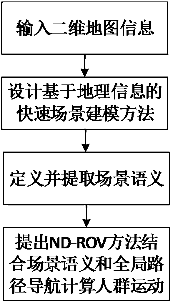
[0074] This embodiment provides a fast crowd evacuation simulation method based on geographic information, such as figure 1 shown, including the following steps:

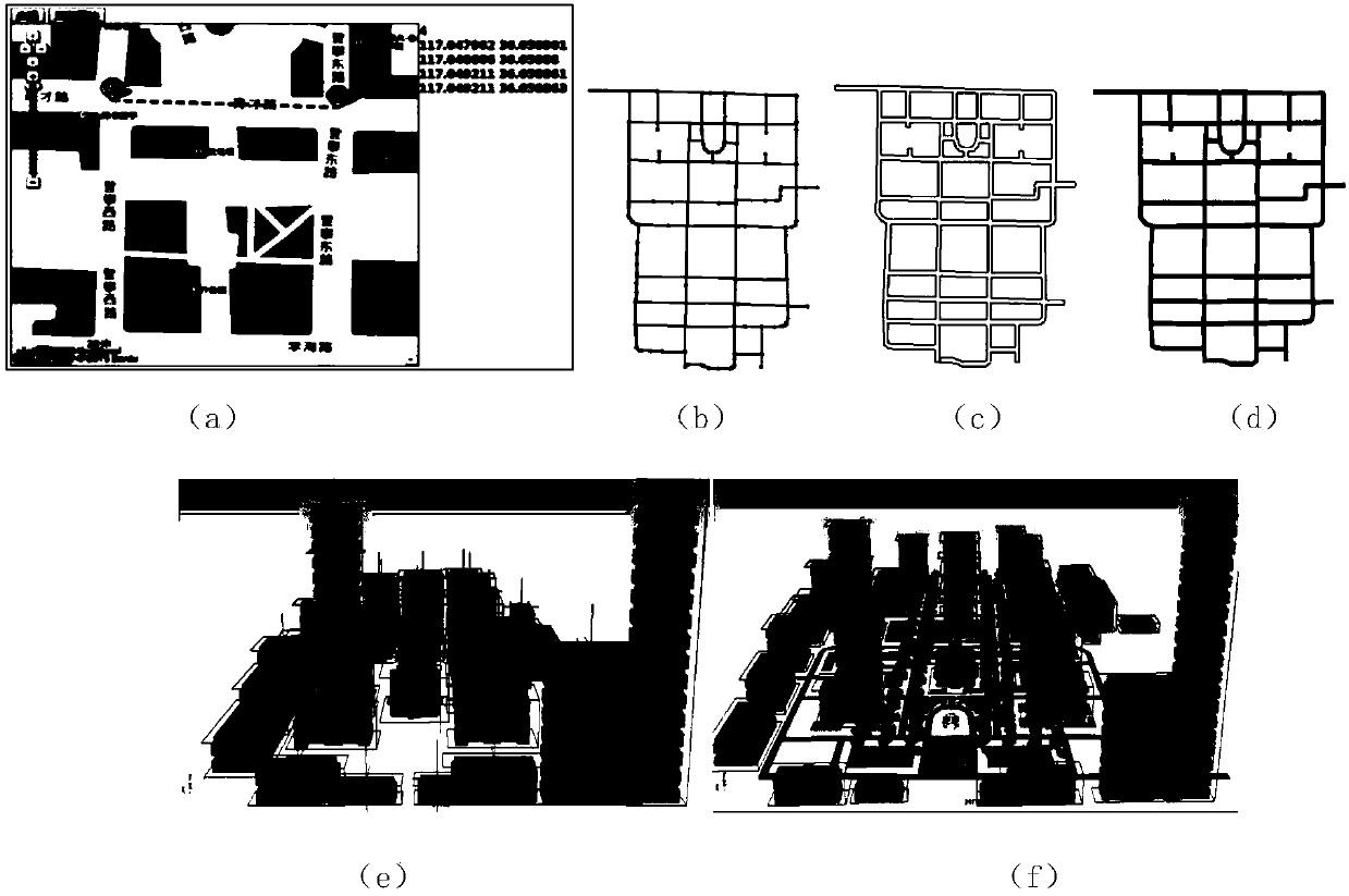
[0075] Step 1: Get a 2D map of the scene.

[0076] Step 2: extract geographic information based on the two-dimensional map, and reconstruct road models and building group models.

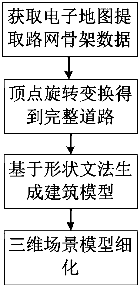
[0077] Step 2.1: extract road skeleton data based on the two-dimensional map, and complete the reconstruction of the road model by adding road width information on the basis of the road skeleton;

[0078] Specifically, each vertex constituting the road polygon is obtained by vector rotation, such as Figure 4 (b). First, take the line p 2 p 3 up point p, it goes to point p 2 The distance is in d is the width of the road. Second, use the formula (1) to rotate the point p counterclockwise by the angle θ to obtain the point p 8 (ie vector counterclockwise), where is the rotation matrix in the two-dimensional coordinate system...

Embodiment 2

[0110] A computer device for rapid crowd evacuation simulation based on geographical information, comprising a display, a graphics processor, a memory and a processor, wherein a computer program is stored in the memory, and it is characterized in that,

[0111] selecting a two-dimensional map of a specified scene based on the human-computer interaction interface on the display;

[0112] The processor is configured to execute the computer program: receiving a two-dimensional map of a scene;

[0113] extracting geographic information based on the two-dimensional map, and reconstructing road models and building group models;

[0114] Establishing a path semantic topology map according to the road skeleton data and the topological relationship between the roads;

[0115] Carrying out crowd motion calculation based on a normal distribution relative speed obstacle method and scene semantics, and transmitting the crowd motion calculation result and the road and building models to a ...


PUM


Abstract

The invention discloses a rapid crowd evacuation simulating method and device based on geographic information. The method includes the following steps of obtaining a two-dimensional map of a scene, extracting the geographic information based on the two-dimensional map, reestablishing a road model and a building group model, establishing a route semantic topological map according to the topologicalrelation between road framework data and a road, conducting crowd movement calculation based on the normal distribution relative speed obstruction method and scene semantics, rendering the crowd movement calculation result, the road and the building group model in combination with a realistic rendering technology to obtain crowd evacuation simulating animation. The method is low in complexity, and crowd evacuation simulating can be efficiently conducted.

Description

technical field [0001] The invention relates to the field of three-dimensional simulation, in particular to a method and device for fast crowd evacuation simulation based on geographic information. Background technique [0002] In recent years, with the continuous development of my country's economy and society, the number of densely populated places has continued to increase, and the issue of safe evacuation of people in public places has become a very important concern in today's society. When an emergency safety accident occurs, how to guide the crowd to evacuate quickly, safely and orderly, and ensure the safety of personnel to the greatest extent has become a research hotspot in the field of public safety. Using computer simulation technology to construct scene models and simulate crowd evacuation is one of the key methods to solve such public safety problems. In order to provide timely decision support, it is particularly important to use virtual scene models for crow...

Claims


Application Information

Patent Timeline
Patent Type & Authority Applications(China)
IPC IPC(8): G06F17/50G06F17/30G06Q10/04
CPCG06Q10/047G06F16/29G06F30/13
Inventor 张桂娟黄丽君张成铭陆佃杰刘弘
Owner SHANDONG NORMAL UNIV
Why Eureka
Try Eureka