Outdoor auxiliary positioning method, system and device based on optical tag
A technology of auxiliary positioning system and positioning equipment, which is applied in the direction of location information-based services, electrical components, wireless communication, etc. It can solve the problems of inability to perform positioning and difficult positioning, and achieves the avoidance of weak or disturbed positioning signals and simple operation , high precision effect
- Summary
- Abstract
- Description
- Claims
- Application Information
AI Technical Summary
Problems solved by technology
Method used
Image
Examples
Embodiment 1
[0055] The specific process of the outdoor auxiliary positioning method of the present invention is:
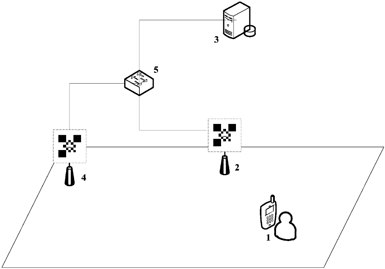
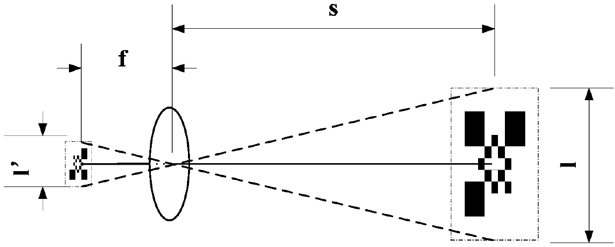
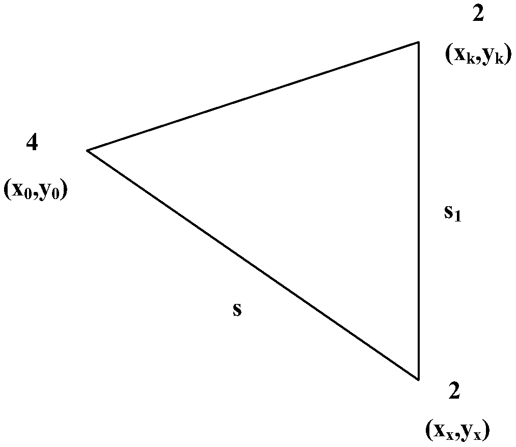
[0056] refer to figure 1 , figure 2 , image 3 and Figure 4 , the outdoor auxiliary positioning method based on light tags of the present invention comprises the following steps:
[0057] 1) Arrange N light tag anchor points within the scope to be located, then set light tags on the light tag anchor points, and then obtain the geographic latitude and longitude information P of each light tag anchor point, where P={(x 1 ,y 1 ),…., (x i ,y i ),..., (x N ,y N)}, where (x i ,y i ) is the latitude and longitude coordinates of the i-th light label anchor point;
[0058] 2) The camera on the device to be positioned 1 collects the image information of the light tags on any two light tag anchor points, and the distance s between the device to be positioned 1 and the first light tag anchor point 4 is obtained 1 and the distance s between the device to be positioned 1 and ...
Embodiment 2
[0070] The operation process of the auxiliary positioning method in the present invention in a specific scenario is as follows:
[0071] An area is subject to strong electromagnetic signal interference and cannot obtain satellite positioning signals. User U needs to perform positioning in this area. Assume that the reference side length of the optical tag is 1 meter, and the focal length of the camera of the mobile terminal held by the user is 30 mm: In order to realize the positioning in this area Positioning, the positioning process is as follows: First, lay out two optical tag anchor point facilities in the area, named A and B respectively, and the serial numbers are 00 and 01, and the coordinates of the two anchor points are determined as: A: (10,10), B :(110,210), upload the data to the positioning server 3 for storage; image acquisition is performed on the anchor point A, and the length of the image forming the anchor point A is 0.3mm, and the light tag data of the anchor...
Embodiment 3
[0073] The operation process of the outdoor auxiliary positioning system in the present invention in a specific scenario is as follows:
[0074] A certain area is subject to strong electromagnetic signal interference and cannot obtain satellite positioning signals. User U needs to perform positioning in this area. Upload to the positioning server for storage; the positioning device collects images of anchor points A and B respectively, and obtains the distance between user U and A and B; user U has advanced the coordinate data of anchor point A and anchor point B from the positioning server After downloading, bring the distance between U and A and B into formula (1) to get the absolute coordinates of user U's location, and it's over.
PUM
 Abstract
Description
Claims
Application Information
 - R&D
- Intellectual Property
- Life Sciences
- Materials
- Tech Scout
- Unparalleled Data Quality
- Higher Quality Content
- 60% Fewer Hallucinations
Browse by: Latest US Patents, China's latest patents, Technical Efficacy Thesaurus, Application Domain, Technology Topic, Popular Technical Reports.
© 2025 PatSnap. All rights reserved.Legal|Privacy policy|Modern Slavery Act Transparency Statement|Sitemap|About US| Contact US: help@patsnap.com


