A method for joint calculation of the distance from the borehole to the formation boundary in horizontal wells with multivariate data

A multivariate data and formation boundary technology, which is applied in the direction of wellbore/well components, complex mathematical operations, earthwork drilling and production, etc., can solve the problem of not directly indicating the wellbore-layer, the difficulty of determining the distance between the wellbore-layer boundary, and the inability of measurement data Directly obtain the distance from the wellbore to the formation to achieve the effect of providing utilization efficiency and enriching formation information

Active Publication Date: 2018-11-02
BC P INC CHINA NAT PETROLEUM CORP +2
View PDF4 Cites 0 Cited by
  • Summary
  • Abstract
  • Description
  • Claims
  • Application Information

AI Technical Summary

Problems solved by technology

[0005] However, in the environment of horizontal wells and highly deviated wells, the LWD curve is affected by various environmental factors, and the measured data cannot directly obtain the distance from the borehole to the formation.
[0006] In fact, well logging data is affected by multiple environments, and the measured value itself does not directly indicate the distance between the wellbore and the layer boundary. It is difficult to determine the distance between the wellbore and the layer boundary in engineering applications, which affects the optimization of the geosteering well trajectory and the later calculation of reserves.

Method used


Image

  • A method for joint calculation of the distance from the borehole to the formation boundary in horizontal wells with multivariate data
  • A method for joint calculation of the distance from the borehole to the formation boundary in horizontal wells with multivariate data
  • A method for joint calculation of the distance from the borehole to the formation boundary in horizontal wells with multivariate data

Examples


Embodiment Construction

[0043] The present invention will be further described below in conjunction with the accompanying drawings and specific embodiments, so that those skilled in the art can better understand the present invention and implement it, but the examples given are not intended to limit the present invention.

[0044] The purpose of the present invention can also be achieved by following technical measures:

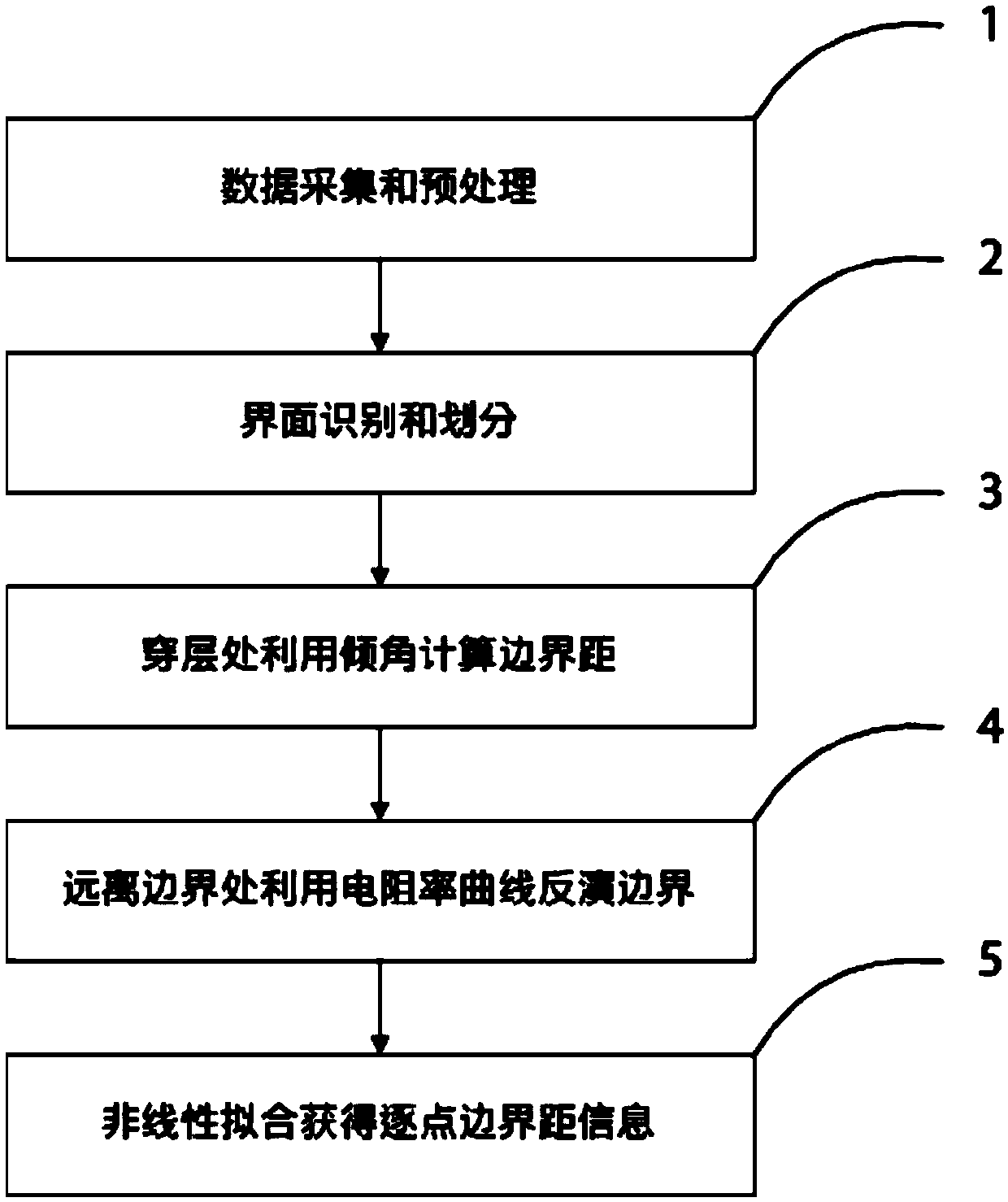
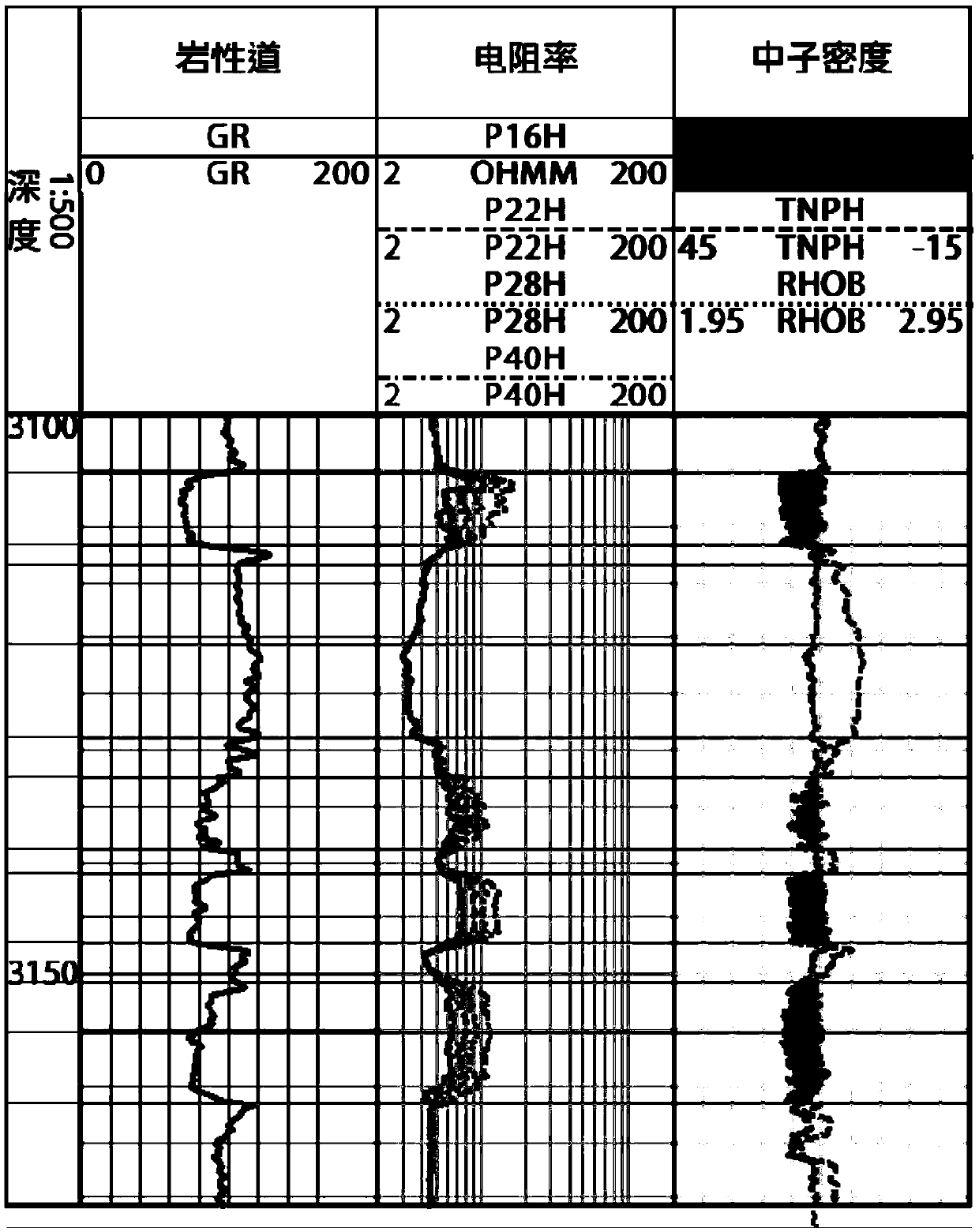
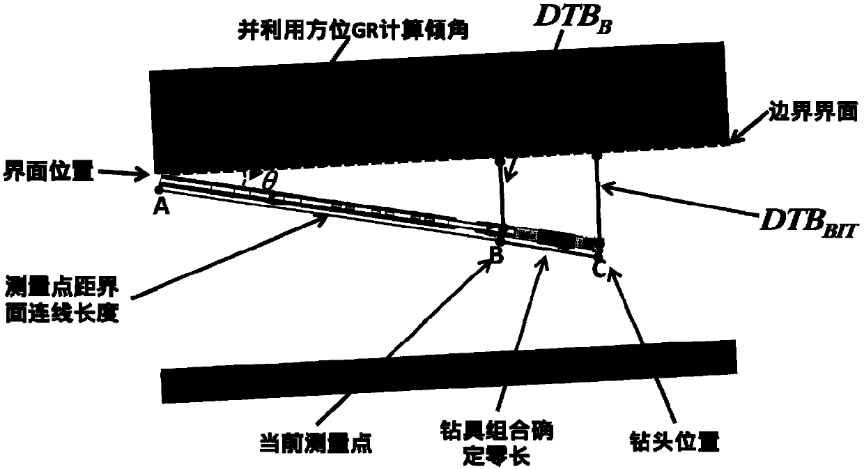
[0045] Step 1, data acquisition and preprocessing: collect the multivariate logging data of the same well, perform preprocessing such as depth alignment, outlier removal and smooth filtering on the measurement data of different tools, and eliminate the influence of invalid data, including several steps:

[0046] 1) According to the response characteristics of GR curve measurement, the multivariate data measured in different times of a well is deeply compressed and stretched, so that the depth of different measurement curves is consistent;

[0047] 2) Standardize the depth-aligned da...


PUM


Abstract

The invention provides a method for utilizing multivariate data to achieve the joint calculation of the distance from a borehole to a stratum boundary in a horizontal well. The method comprises the steps of 1, collecting and preprocessing the multivariate logging data; 2, utilizing the logging data for interface identification, and automatically conducting horizon division; 3, utilizing azimuth imaging data to calculate the borehole-stratum relative inclination angle and azimuth angle at the position cross an interface, and calculating the boundary distance according to the inclination angle;4, establishing an inversion model, and calculating the borehole-boundary distance of the position away from the boundary section by section; 5, summarizing inclination angle data at the boundary andinversion layer boundary distance data of the position away from the boundary, and obtaining the borehole-boundary distance of each measurement point of the horizontal well according to nonlinear interpolation. By means of the method, the borehole-stratum boundary distance information can be obtained from the logging data, so that the method is a data processing technology urgently needed in production; meanwhile, the detection advantages of various types of logging data are fully exerted and comprehensively utilized and complement one other, and the efficiency of utilizing the logging data isimproved.

Description

technical field [0001] The invention relates to the technical field of oilfield development, in particular to a technique for jointly calculating the distance from a wellbore to a stratum boundary with multiple data in a horizontal well. Background technique [0002] With the massive exploitation of oil, the monolithic oil and gas reservoirs gradually decreased, and the complex and difficult-to-move oil and gas reservoirs gradually increased. At the end of the 20th century, in order to meet the development needs of the petroleum industry, especially to improve drilling efficiency and reservoir recovery, water Hirai geosteering technology has gradually developed. In the early 1980s, with the maturity of directional well technology and the application of new downhole tools and instruments, horizontal well drilling entered a period of vigorous development. Logging while drilling has become an important means of reservoir evaluation for highly deviated wells, horizontal wells a...

Claims


Application Information

Patent Timeline
Patent Type & Authority Patents(China)
IPC IPC(8): G06F17/15E21B47/00
CPCE21B47/00G06F17/15
Inventor 刘乃震伍东傅少庆郭玉庆樊春华刘越
Owner BC P INC CHINA NAT PETROLEUM CORP
Why Eureka
Try Eureka