A Method of Wetland Information Extraction and Ecological Sensitivity Evaluation Based on Microwave Remote Sensing and Optical Remote Sensing Technology

An information extraction and optical remote sensing technology, applied in the field of remote sensing, can solve the problems of low accuracy, inability to extract, and difficult to guarantee accuracy, and achieve the effect of reducing workload

Active Publication Date: 2020-12-22
CHINA ACAD OF TRANSPORTATION SCI
View PDF6 Cites 0 Cited by
  • Summary
  • Abstract
  • Description
  • Claims
  • Application Information

AI Technical Summary

Problems solved by technology

The accuracy of wetland remote sensing extraction is still relatively low among all kinds of wetlands. This is mainly because swampy wetlands are generally not like rivers and lakes. Almost all of its pixels are mixed pixels, and it is not easy to extract from a more complex surface environment. distinguished from
The traditional wetland information extraction method is based on manual visual interpretation of optical images, which requires high manpower, financial resources and time costs, and the accuracy is not high
In addition, optical remote sensing images cannot extract "invisible" wetland types such as forest wetlands, so the accuracy is even more difficult to guarantee

Method used


Image

  • A Method of Wetland Information Extraction and Ecological Sensitivity Evaluation Based on Microwave Remote Sensing and Optical Remote Sensing Technology
  • A Method of Wetland Information Extraction and Ecological Sensitivity Evaluation Based on Microwave Remote Sensing and Optical Remote Sensing Technology
  • A Method of Wetland Information Extraction and Ecological Sensitivity Evaluation Based on Microwave Remote Sensing and Optical Remote Sensing Technology

Examples


Embodiment Construction

[0073] Below in conjunction with accompanying drawing and specific embodiment the present invention is described in further detail:

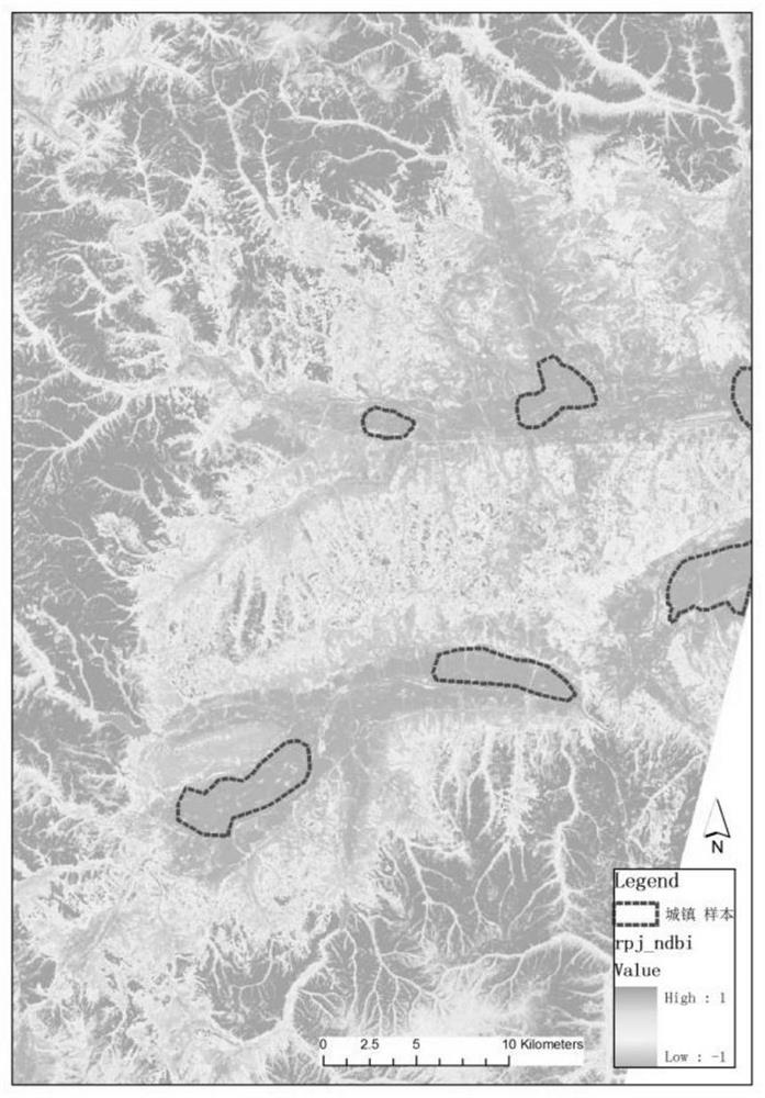
[0074] A certain expressway is located in the concentrated distribution area of ​​wetlands in the cold region of Northeast China. The vegetation types along the way are mainly swamp wetlands in cold regions, mixed coniferous and broad-leaved forests, and crops. The work is carried out scientifically and efficiently, and the method proposed by the inventor has been adopted.

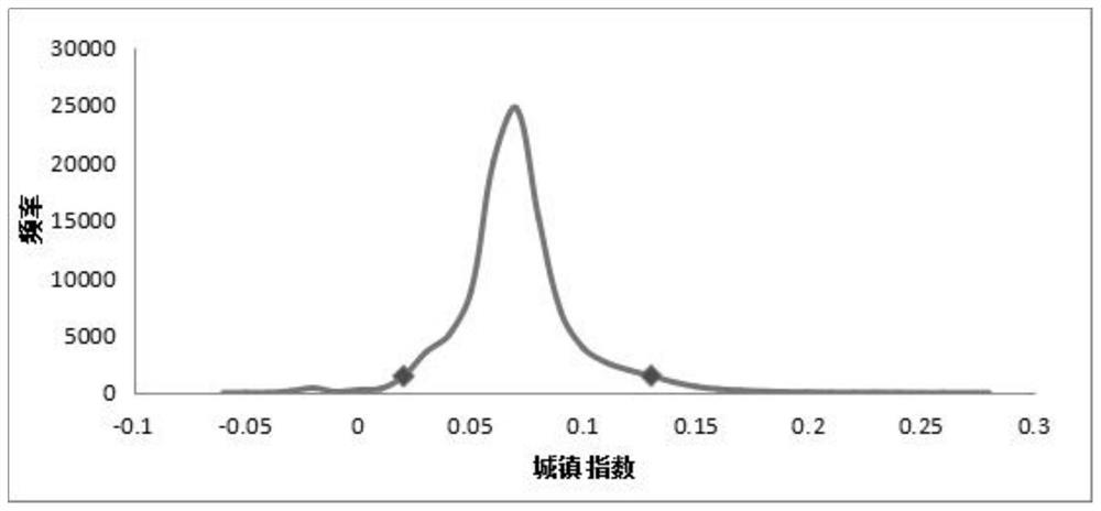
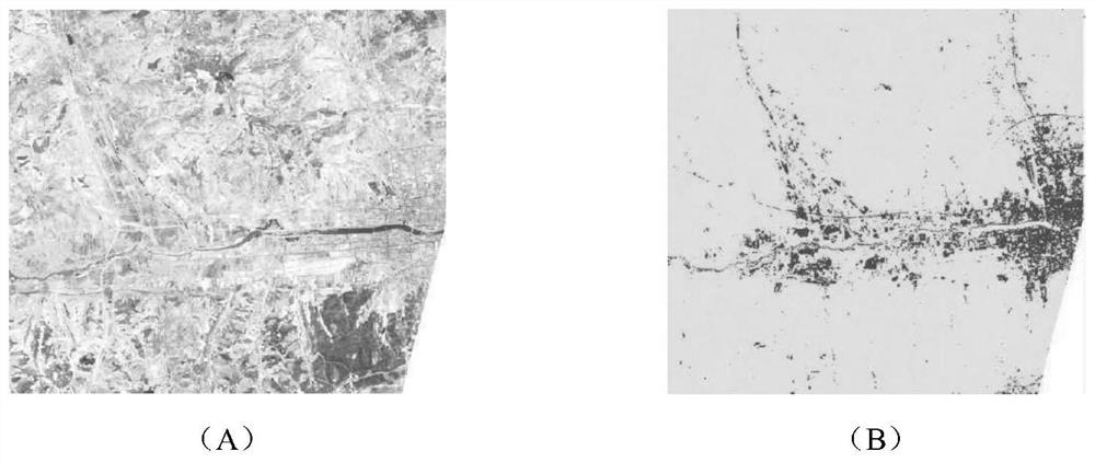
[0075] The main idea is to use NDBI urban index and TM image as the data source to extract urban and farmland information. The above information is spatially registered with microwave remote sensing data, and the corresponding information is easily removed. The remaining data are then applied to different polarization data and cross-polarization data of microwave remote sensing. For the scattering characteristics, the image threshold segmentation method is used to divide th...


PUM


Abstract

The invention discloses a method for wetland information extraction and ecological sensitivity evaluation based on microwave remote sensing and optical remote sensing technology, which overcomes the existing disadvantages of wetland information extraction based on optical remote sensing data, and develops a method according to the characteristics of optical remote sensing and microwave remote sensing data. Extract information from different types of wetlands such as marsh wetlands, forest wetlands, and water areas, identify information such as wetland distribution, wetland soil moisture, and wetland water systems, establish wetland ecological sensitivity evaluation models, and carry out roadside buffer wetland ecological sensitivity evaluations to improve The extraction accuracy is improved, the extraction method is simpler, more suitable for popularization and utilization, and is very suitable for wetland information extraction.

Description

technical field [0001] The invention belongs to the technical field of remote sensing, and relates to a method for extracting and evaluating wetland ecosystem information in a highway buffer zone, in particular to a method for extracting wetland information and evaluating ecological sensitivity based on microwave remote sensing and optical remote sensing technologies. Background technique [0002] With the continuous extension and development of the road network, road construction has inevitably affected the wetland ecology. If the wetland is directly occupied, the vegetation will be destroyed, and an interface will be formed after completion, which will block the flow of matter, energy and species. But wetlands are by far the least descriptive category of landscape. Although traditional field investigation methods can be used to detect the distribution of wetlands relatively accurately, wetlands are usually located on muddy and uneven surfaces, and are mostly distributed i...

Claims


Application Information

Patent Timeline
Patent Type & Authority Patents(China)
IPC IPC(8): G06K9/00G06K9/34G06T17/05G06Q10/06
CPCG06Q10/0639G06T17/05G06V20/188G06V10/267
Inventor 杨艳刚王新军张利东简丽陶双成姚嘉林关磊高硕晗王倜熊新竹
Owner CHINA ACAD OF TRANSPORTATION SCI
Why Eureka
Try Eureka