Eureka AIR delivers breakthrough ideas for toughest innovation challenges, trusted by R&D personnel around the world.

Adaptive imaging positioning navigation system and method for driverless vehicle

An unmanned vehicle, positioning and navigation technology, applied in the field of visible light imaging communication, can solve the problems of limiting communication environment parameters, difficult application and promotion, limiting the development of visible light imaging communication technology, etc., to achieve the effect of improving the range of change

Active Publication Date: 2018-03-30
深圳市光域物联科技有限公司
View PDF9 Cites 7 Cited by
  • Summary
  • Abstract
  • Description
  • Claims
  • Application Information

AI Technical Summary

Problems solved by technology

For an imaging communication system, a fixed modulation method and a fixed data detection algorithm are used, which limit the parameters of the communication environment and are not easy to be applied and promoted
[0018] (2) Visible light imaging communication is only used in local application fields, which limits the development of visible light imaging communication technology

Method used


Image

  • Adaptive imaging positioning navigation system and method for driverless vehicle
  • Adaptive imaging positioning navigation system and method for driverless vehicle
  • Adaptive imaging positioning navigation system and method for driverless vehicle

Examples


Embodiment

[0054] Embodiment: The camera at the receiving end takes the camera of a Samsung Galaxy S8 mobile phone as an example, and the shutter speed is set to 1 / 24000. The sending end adopts OOK modulation technology (the signal source is the indicator light). When the transmission distance is 50cm and 1m, the frame image captured by the camera at the receiving end is as follows: Figure 7 Shown; Among them, when the communication distance is 50cm, the frame image is as follows Figure 7 As shown in (a), min can be obtained through optimization calculation sharpness >threshold, that is, the sending end adopts the OOK modulation technology at this time, and the receiving end adopts the corresponding conventional detection method (that is, the preset detection method corresponding to the OOK modulation technology); when the communication distance is 1m, the frame image such as Figure 7 As shown in (b), min can be obtained by calculation sharpness <threshold, that is, at this time, th...


PUM


Abstract

The embodiment of the invention discloses an adaptive imaging positioning navigation system and method for a driverless vehicle. The adaptive imaging positioning navigation system for the driverless vehicle comprises a sending end and a receiving end; the sending end sends original data including positioning navigation information through a visible light signal; and the receiving end is arranged on the driverless vehicle, used to receive the visible light signal and recover the visible light signal to obtain the original data; wherein the sending end comprises a indicator light and a street light, and the receiving end comprises a camera, a motor, a photosensitive sensor and a processor; the receiving end controls the rotation of the camera through the motor, and activates the camera to receive the optical signal and obtain the original data. According to the embodiment of the invention, the street light and the indicator light are used as the signal sources of the positioning navigation, and the variation range of the communication distance is improved by means of an adaptive switching mode, therefore, the problem that the communication mode is fixed and can only be applied to local application fields is solved, and the technical effects that the communication mode can be applied to different communication scenarios and the visible light communication technology is applied tothe field of the positioning navigation are achieved.

Description

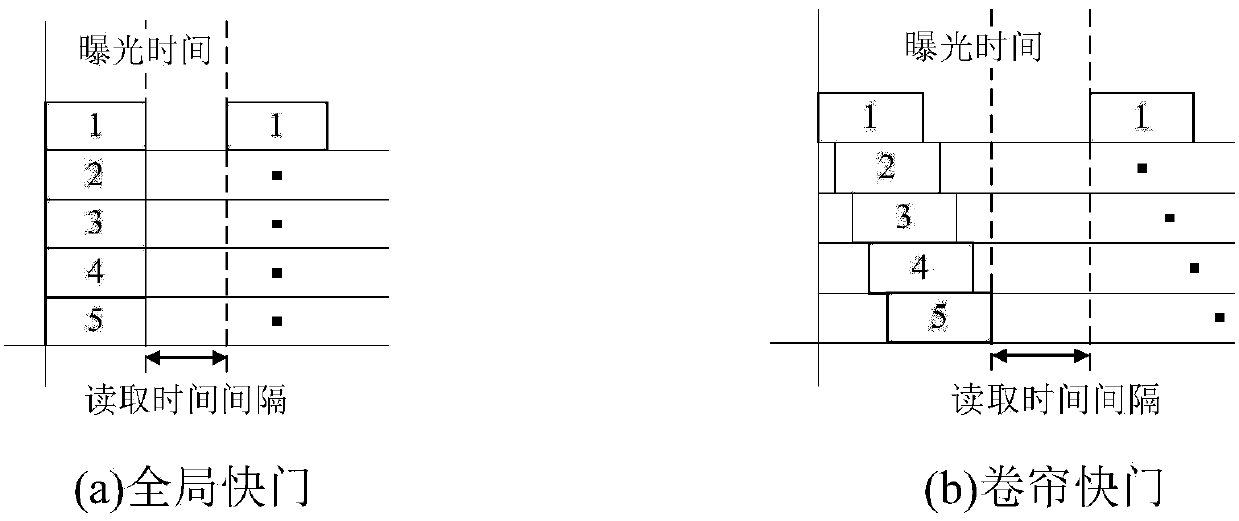
technical field [0001] The invention relates to the technical field of visible light imaging communication, in particular to an adaptive imaging positioning navigation system and method for unmanned vehicles. Background technique [0002] In 2012, relevant researchers first proposed a visible light imaging communication method based on the rolling shutter effect. For the CMOS imaging reception of indoor visible light, the Chow, C.W. team from Taiwan used the rolling door characteristics of the CMOS camera equipment, used a variety of image processing algorithms to optimize the received pictures, demodulated and restored the original signal, and finally achieved a rate of 0.8Kb / s The data transmission can basically meet the simple needs of indoor positioning and indoor optical tag information reception. [0003] In 2014, the Electronic Information Engineering Laboratory of Tongji University cooperated with National Taiwan University to conduct a series of research on vehicle...

Claims


Application Information

Patent Timeline
Patent Type & Authority Applications(China)
IPC IPC(8): H04B10/116H04B10/556H04W4/029H04W4/40
Inventor 吴江
Owner 深圳市光域物联科技有限公司
Why Eureka
Eureka Blog
Learn More