Three-dimensional surveying and mapping system based on GPS (global positioning system)/Beidou

A Beidou, three-dimensional technology, applied in the field of surveying and mapping, can solve the problems of difficult access for surveying and mapping personnel, expensive manufacturing and R&D costs, and increase the difficulty of surveying and mapping, and achieves the effect of increasing the range of surveying and mapping, facilitating handling, and increasing practicability.

Inactive Publication Date: 2018-04-13
CHENGDU ZHONGDING TECH
View PDF0 Cites 1 Cited by
  • Summary
  • Abstract
  • Description
  • Claims
  • Application Information

AI Technical Summary

Problems solved by technology

However, the existing mobile surveying and mapping devices are complex in structure, and the cost of manufacturing research and development is too expensive, which has a certain impact on their popularization and promotion; and some special geographical locations are difficult for surveying and mapping personnel to reach, which greatly increases the difficulty of surveying and mapping

Method used


Image

  • Three-dimensional surveying and mapping system based on GPS (global positioning system)/Beidou
  • Three-dimensional surveying and mapping system based on GPS (global positioning system)/Beidou

Examples


Embodiment Construction

[0014] In order to have a clearer understanding of the technical features, objects and effects of the present invention, the specific embodiments of the present invention will now be described with reference to the accompanying drawings.

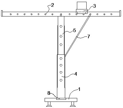
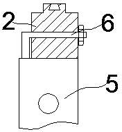
[0015] like figure 1 As shown, a three-dimensional surveying and mapping system based on GPS / Beidou includes a base 1, a cylindrical piece, a guide rail 2, a surveying and mapping trolley 3 and a GPS or Beidou mapping instrument, and the cylindrical piece includes a first cylindrical piece 4 and a second Two cylindrical pieces 5 , a turntable 8 is embedded in the middle of the base 1 , the first cylindrical piece 4 is fixedly connected to the turntable 8 , and the first cylindrical piece 4 is screwed to the second cylindrical piece 5 , the first cylindrical member 4 is provided with an external thread, the second cylindrical member 5 is provided with an internal thread, the upper end of the second cylindrical member is provided with a fixed ...


PUM


Abstract

The invention discloses a three-dimensional surveying and mapping system based on GPS/Beidou, which includes a base, a cylindrical part, a guide rail, a surveying and mapping trolley and a GPS or Beidou surveying instrument, and the cylindrical part includes a first cylindrical part and a second cylindrical part part, the middle part of the base is embedded with a turntable, the first cylindrical part is fixedly connected with the turntable, the first cylindrical part is screwed to the second cylindrical part, and the first cylindrical part is provided with an external thread , the second cylindrical member is provided with an internal thread, the upper end of the second cylindrical member is provided with a fixed connector, the cross section of the guide rail is “convex” shape, and the top surface of the guide rail is provided with a guide slide groove along the direction of the guide rail, The side of the guide rail is provided with a plurality of through holes perpendicular to the guide chute. The fixed connector passes through the through holes and is locked by a nut. The first cylindrical part is hinged with a telescopic rod, and the free movement of the telescopic rod The end is provided with a block, and the surveying and mapping trolley is placed on the guide rail, and is slidably connected with the guide rail through the connecting chain. The present invention is easy to disassemble and has increased practicability.

Description

technical field [0001] The invention relates to the technical field of surveying and mapping, in particular to a three-dimensional surveying and mapping system based on GPS / Beidou. Background technique [0002] With the development of geographic information system and digital city construction, the degree of automation of surveying and mapping technology has become higher and higher. The method of surveying and mapping is mainly through manual surveying and mapping. Specifically, surveying and mapping personnel use professional surveying and mapping instruments to perform outdoor operations to obtain high-precision surveying and mapping data. In recent years, the rapid development of mobile surveying and mapping technology is an important direction for the future development of surveying and mapping technology. Its efficiency is greatly improved compared with manual surveying and mapping, and the surveying and mapping area is wider. However, the existing mobile surveying an...

Claims


Application Information

Patent Timeline
Patent Type & Authority Applications(China)
IPC IPC(8): G01C15/00G01S19/14
CPCG01C15/00G01S19/14
Inventor 王静宫宗杰冯阳魏新平张镧李家豪鲜孟兵
Owner CHENGDU ZHONGDING TECH
Why Eureka
Try Eureka