
Mobile augmented reality matching method for virtual coordinates and construction field coordinates

A technology of virtual coordinates and construction sites, applied in the application field of mobile augmented reality technology in engineering, to achieve the effect of speeding up construction progress and saving investment

Active Publication Date: 2018-04-24
河南省水利勘测设计研究有限公司
View PDF7 Cites 8 Cited by
  • Summary
  • Abstract
  • Description
  • Claims
  • Application Information

AI Technical Summary

Problems solved by technology

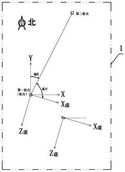
People try to apply mobile augmented reality technology to the construction site stakeout, but the problem is that the construction site often adopts a site coordinate system based on fixed pile points. The coordinate system takes the fixed pile point as the coordinate origin and the east-west direction as X Axis, the north-south direction is the Y axis, and the vertical direction is the Z axis

Method used


Image

  • Mobile augmented reality matching method for virtual coordinates and construction field coordinates
  • Mobile augmented reality matching method for virtual coordinates and construction field coordinates

Examples


Embodiment Construction

[0013] The embodiments of the present invention will be described in detail below in conjunction with the accompanying drawings. This embodiment is implemented on the premise of the technical solution of the present invention, and detailed implementation methods and specific operating procedures are provided, but the scope of protection of the present invention is not limited to the following Described embodiment.

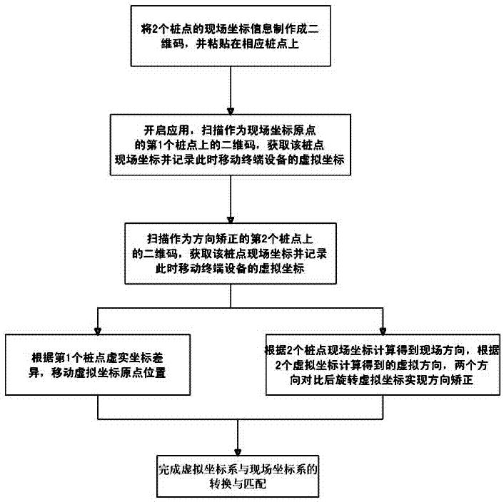
[0014] The mobile augmented reality virtual coordinate and construction site coordinate matching method described in the present invention, after importing the engineering three-dimensional design model into three-dimensional engines such as Scenekit, adopts mobile augmented reality interfaces such as Arkit to develop engineering mobile augmented reality application systems, such as figure 2 As shown, that is: when the mobile terminal device automatically establishes a virtual coordinate system when the application is started, the virtual coordinate system takes th...


PUM


Abstract

The invention discloses a mobile augmented reality matching method for virtual coordinates and construction field coordinates. The method includes I, establishing an application system developed basedon an Arkit interface; II, pasting a two-dimensional code with pile point field coordinate information on two pile points in a construction field; III, placing a mobile terminal device exactly abovethe first pile point as an origin of coordinates and scans the two-dimensional code on the first pile point, acquires the field coordinates of a field coordinate system of the pile point, and acquiresthe virtual coordinates of the mobile terminal device in the virtual coordinate system synchronously, and modifying the position of the origin of coordinates of the virtual coordinate system; IV, through scanning the two-dimensional code on the second pile point, acquiring the field coordinates of the second pile point in the field coordinate system and the virtual coordinates of the mobile terminal device in the virtual coordinate system, and implementing the matching of virtual coordinates and field coordinates finally.

Description

technical field [0001] The invention relates to the application of mobile augmented reality technology in engineering, in particular to a method for matching virtual coordinates of mobile augmented reality with coordinates of a construction site. Background technique [0002] Augmented reality (English: Augmented Reality, referred to as AR) is a visualization technology that superimposes virtual text, images, and three-dimensional models in real scenes. With the improvement of the performance of mobile terminal equipment such as smartphones and Ipads (laptops, tablets), and the improvement of related spatial perception technologies, augmented reality technology has gradually moved from the PC terminal to the mobile terminal, from the two-dimensional enhancement of superimposed simple pictures and text Reality is moving towards the three-dimensional augmented reality that perceives the real three-dimensional space and can accurately place the three-dimensional virtual model i...

Claims


Application Information

Patent Timeline
IPC IPC(8): G06T19/00G06F17/50G06Q50/08
CPCG06Q50/08G06T19/006G06F30/13
Inventor 屈志刚贾少燕方祥宇赵蓓蓓赵庆鹤孙卫宾史亚军薛向华孙哲来亦姝
Owner 河南省水利勘测设计研究有限公司
Learn More