GIS display method, device and system

A display method and a technology for configuring data, applied in the field of geographic information, can solve problems such as complex operation and difficult modification, and achieve the effects of simple operation, improved visibility, and convenient modification

Inactive Publication Date: 2018-06-12
BEIJING E TECHSTAR
View PDF4 Cites 5 Cited by
  • Summary
  • Abstract
  • Description
  • Claims
  • Application Information

AI Technical Summary

Problems solved by technology

[0005] In view of this, the purpose of the present invention is to provide a GIS display method, device and system to improve the technical problems of difficult modification and complicated operation in the GIS display platform, so as to make the modification more convenient and the operation easier

Method used


Image

  • GIS display method, device and system
  • GIS display method, device and system
  • GIS display method, device and system

Examples


Embodiment 1

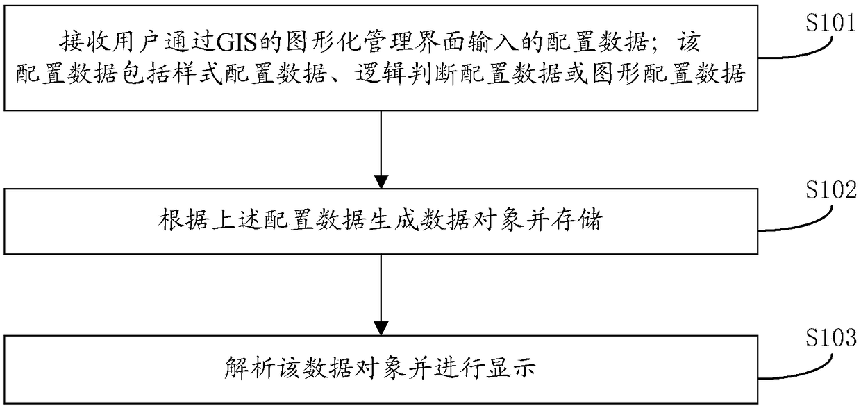
[0041] Such as figure 1 Shown is a schematic flow chart of a GIS display method provided by an embodiment of the present invention, the steps of which include:

[0042] S101: Receive the configuration data input by the user through the graphical management interface of the GIS; the configuration data includes style configuration data, logic judgment configuration data or graphic configuration data.

[0043] The combination engine receives the configuration data input by the user through the graphical management interface of the GIS. The graphical management interface corresponds to configurable styles, logical judgments, and graphical parameters, and the code that needs to be modified is displayed on the operation interface in the form of a window through programming.

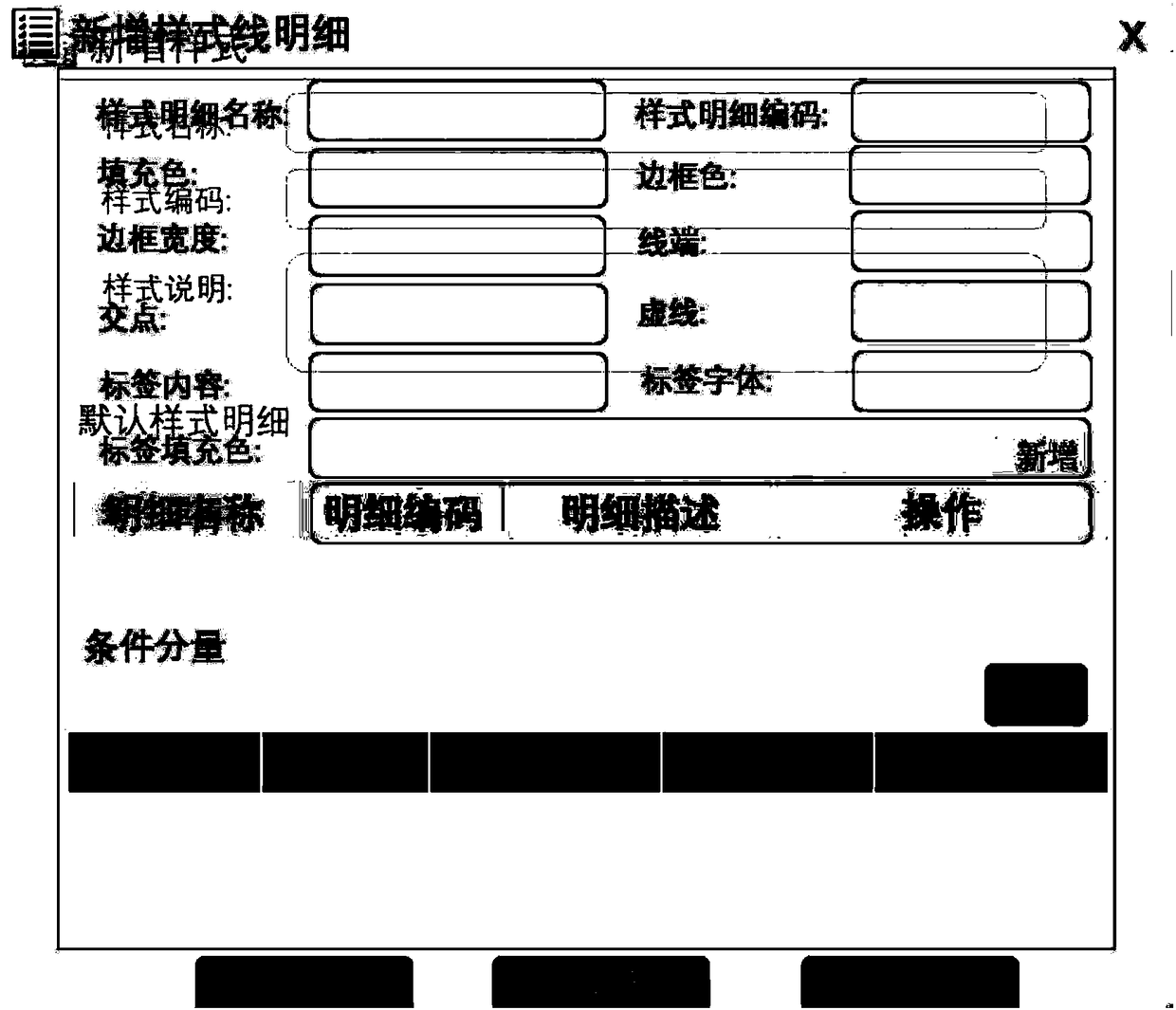
[0044] The input of the above configuration data includes: the combination engine receives the style configuration data input by the user through the style management interface, and the style configuration dat...

Embodiment 2

[0068] Existing GIS platforms can only display GIS-related models, and cannot customize various graphics and display methods required by users, such as: PPT mode, customized background image, etc. In view of this situation, the embodiment of the present invention provides a method based on the above implementation The method of implementing graphic customization in the example method is described below using the example of customizing the display base map in PPT mode.

[0069] Such as Figure 6 As shown, it is a schematic flowchart of a method for customizing a base map using GIS provided by an embodiment of the present invention, and introduces the specific steps of graphic customization, including:

[0070] S601: Receive a customized picture input by a user through a graphical management interface.

[0071] In the graphic management, import the map background picture that needs to be displayed including the four provinces of Henan, Hubei, Hunan and Jiangxi. In addition to t...

Embodiment 3

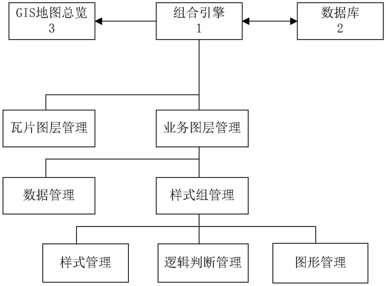
[0080] The embodiment of the present invention also provides a GIS display device, such as Figure 8 Shown is a schematic structural diagram of a GIS display device provided by an embodiment of the present invention, consisting of Figure 8 It can be seen that the GIS display device includes: a receiving module 810, configured to receive configuration data input by a user through a graphical management interface of GIS; the configuration data includes style configuration data, logic judgment configuration data or graphic configuration data; The data object is generated and stored according to the above configuration data; the display module 830 is configured to analyze and display the above data object.

[0081] Wherein, the above-mentioned receiving module 810 is also used to receive the style configuration data input by the user through the style management interface, the style configuration data includes the color, border, size or label of the vector diagram; and is used to...


PUM


Abstract

The invention provides a GIS display method, device and system, and relates to the technical field of geographic information. The GIS display method includes the steps of receiving layout data input through a GIS graphical management interface by a user, wherein the layout data includes style layout data or logical judgment layout data or graph layout data; according to the layout data, generatingand saving a data object; parsing and displaying the data object. The GIS display method, device and system aim at that the user does not need to manually carry out code modification or file configuration, so that modification is more convenient, and operation is easier; moreover, by means of the GIS display method, graphic customization and three-dimensional GIS display can be further conducted,so that the visuality of the system is greatly improved.

Description

technical field [0001] The invention relates to the technical field of geographic information, in particular to a GIS display method, device and system. Background technique [0002] With the development of the power system, there is real-time monitoring of the operation of the power system. For example, each power dispatching department monitors the actual geographical location and real-time operation of related equipment (such as: substations, towers, etc.) that undertake power transmission. The existing monitoring method is to use the GIS geographic display platform. The GIS (Geographic Information System, geographic information system) display platform can mark the geographic location of the relevant equipment on the map in real time, and can clearly display the alarm information of the relevant equipment combined with the data interface. And the operation status, so that relevant departments can take timely countermeasures. [0003] However, the display model of the ex...

Claims


Application Information

Patent Timeline
Patent Type & Authority Applications(China)
IPC IPC(8): G06F9/451G06F9/445G06F17/30
CPCG06F9/4451G06F16/29
Inventor 钱苏晋谢海疆樊伟曹坤童晶晶
Owner BEIJING E TECHSTAR
Why Eureka
Try Eureka