Method for calculating coverage range of line-of-sight link of flight of UAV (unmanned aerial vehicle)

A technology of coverage and calculation method, applied in the field of flight test, can solve the problem that cannot be used to guide UAV flight route planning link planning, cannot estimate the relationship between terrain occlusion boundary elevation angle, azimuth and flight altitude, flight distance, etc. question

Active Publication Date: 2018-07-06
CHENGDU AIRCRAFT DESIGN INST OF AVIATION IND CORP OF CHINA
View PDF10 Cites 17 Cited by
  • Summary
  • Abstract
  • Description
  • Claims
  • Application Information

AI Technical Summary

Problems solved by technology

Even if a person stands next to the antenna and uses an optical angle measuring instrument or visually observes the surrounding environment, he can roughly evaluate the elevation angle and azimuth corresponding to the t...

Method used


Image

  • Method for calculating coverage range of line-of-sight link of flight of UAV (unmanned aerial vehicle)
  • Method for calculating coverage range of line-of-sight link of flight of UAV (unmanned aerial vehicle)
  • Method for calculating coverage range of line-of-sight link of flight of UAV (unmanned aerial vehicle)

Examples


Embodiment Construction

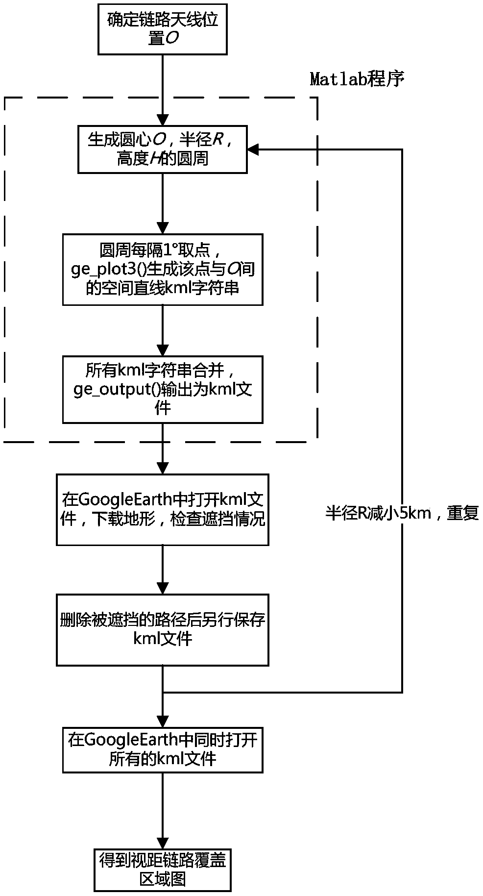
[0021] The use of the present invention includes: GoogleEarth, Matlab, Matlab to GoogleEarth toolbox and other specific application examples of tool software are as follows. The above-mentioned software tools, other software and data capable of realizing the required functions of the present invention can all be used to support the realization of the present invention.

[0022] Google Earth provides free global satellite images and elevation data, and can update the terrain data of designated areas on the Internet at any time as needed. GoogleEarth supports kml files. Through the description of kml files, elements such as points, lines, and surfaces can be generated in the 3D terrain of GoogleEarth. The format description of the kml file can be found on the Internet http: / / www.opengeospatial.org / standards / kml / . If it is time-consuming to describe the 3D data by manually writing the kml file, third-party software can be used to generate the kml file. Typical of these is the Ma...


PUM


Abstract

The invention relates to a method for detecting a coverage range of a line-of-sight link during flight path planning of an UAV (unmanned aerial vehicle) before a flight test, and belongs to the technical field of flight tests. According to the method, three-dimensional topographic data is used as a basis, and an action range of the line-of-sight link in the case of terrain masking can be generatedby setting of parameters such as geographic location information of a line-of-sight link station, a radio unshielded distance, and flight height to be inspected. The method combines three-dimensionalterrain with the UAV and a radio transmission path, and completes the calculation and inspection of the radio coverage range of the line-of-sight link of the flight of the UAV, and solves the problemthat the action range of the line-of-sight link cannot be accurately estimated when the UAV flies in complex terrain environment. The method is applicable to the flight path planning check during theflight of the UAV (unmanned aerial vehicle). The method can also be used to calculate an action range of a ground-to-air radar, and is suitable for evaluation of station distribution site selection of radar base stations.

Description

technical field [0001] The invention belongs to the field of flight test technology, in particular to link planning in the flight test planning of unmanned aerial vehicle under complex terrain environment. Background technique [0002] The flight of UAV is mainly based on autonomous control flight, and the pilot monitors the UAV and transmits mission data remotely through the line-of-sight link or satellite link on the ground. Due to its large bandwidth and fast transmission rate, the line-of-sight link is usually used for short-distance flight and large-capacity reconnaissance data transmission. But it also has obvious disadvantages. First, the transmission distance is limited due to the curvature of the earth and its own power. Second, it is necessary to ensure that there is no obvious occlusion between the ground link antenna and the UAV, otherwise the signal will be interrupted. At present, the surrounding terrain of most airports in China is relatively flat. When the f...

Claims


Application Information

Patent Timeline
IPC IPC(8): G01C21/20H04W16/18
CPCG01C21/20H04W16/18
Inventor 杨指顺罗程赵霞江宇娟冉骁
Owner CHENGDU AIRCRAFT DESIGN INST OF AVIATION IND CORP OF CHINA
Why Eureka
Try Eureka