Multi-line laser radar and GPS-based three-dimensional road construction method

A multi-line laser, three-dimensional road technology, applied in 3D modeling, re-radiation of electromagnetic waves, radio wave measurement systems, etc. problem, to achieve the effect of clean 3D road map, high cost performance and small error

Inactive Publication Date: 2018-07-06
清华大学苏州汽车研究院(吴江) +1
View PDF6 Cites 28 Cited by
  • Summary
  • Abstract
  • Description
  • Claims
  • Application Information

AI Technical Summary

Problems solved by technology

[0002] The current common 3D map construction method is to simulate the 3D model of the road through the geographical location of the road, which cannot restore the real road information, such as trees and buildings around the road; Reconstructing the 3D model of the road, this method is complex and the accuracy is not high
[0003] With the advent of multi-line lidar, it has become a new technology to build a 3D model through multi-line lidar. At present, the common multi-line lidar such as 32-line and 64-line lidar, although the collected point cloud data can roughly establish the surrounding area. 3D model, but because the point cloud data is too discrete and not dense enough, and there is no relevant information between multi-frame point cloud data, information cannot be reused, so it is not enough to build a 3D map of the real road, and due to technology and cost However, it is not practical to use lidar with more wire harnesses to build 3D models

Method used


Image

  • Multi-line laser radar and GPS-based three-dimensional road construction method
  • Multi-line laser radar and GPS-based three-dimensional road construction method

Examples


Embodiment

[0025] The preferred embodiments of the present invention will be further described below in conjunction with the accompanying drawings.

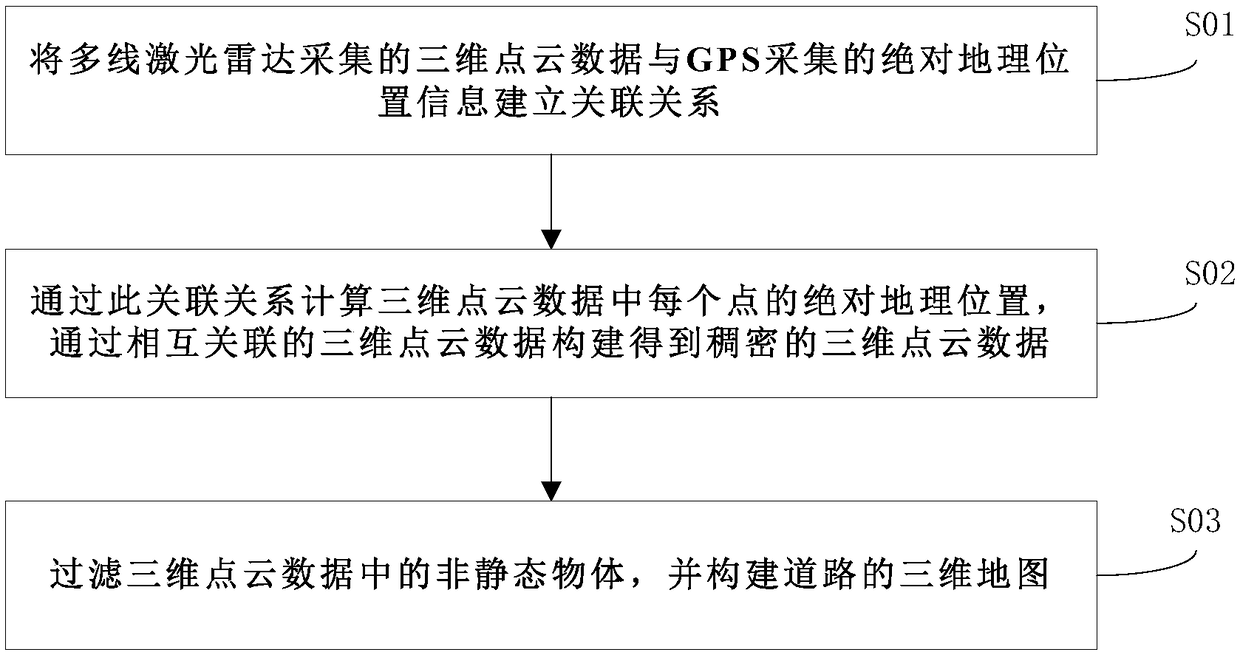
[0026] Such as figure 1 As shown, a 3D road construction method based on multi-line lidar and GPS includes the following steps:

[0027] S01: Establish a relationship between the 3D point cloud data collected by multi-line lidar and the absolute geographic location information collected by GPS; mainly the time and space relationship of 3D point cloud data.

[0028] S02: Calculate the absolute geographic location of each point in the 3D point cloud data through this relationship, and construct dense 3D point cloud data through the construction of interrelated 3D point cloud data;

[0029] S03: Filter non-static objects in 3D point cloud data and build a 3D map of the road.

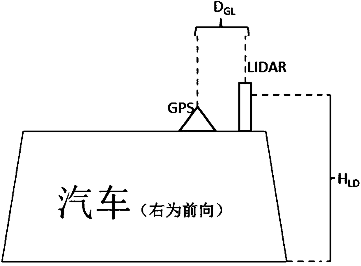
[0030] Such as figure 2 As shown, in the data collection stage, an adjustable multi-line lidar is installed. The lidar wiring harness should be more than 32 lines as...


PUM


Abstract

The invention discloses a multi-line laser radar and GPS-based three-dimensional road construction method. According to the invention, the three-dimensional point cloud data of an all-angle and all-directional surrounding space can be dynamically collected through adjusting a multi-line laser radar and a high-precision GPS. Meanwhile, collected discrete non-associated sparse point cloud data are correlated through the absolute geographic position information acquired by the high-precision GPS, and then the absolute geographic position of each point in the point cloud data is calculated throughthe correlation. Therefore, radar point cloud data collected at different time and in different tracks can be fully and effectively utilized. Finally, the point cloud data which are dense enough areobtained through mutually correlated point cloud data. After that, dynamic objects in the point cloud data are filtered out through the differential method. In this way, the three-dimensional map of areal road can be constructed based on the remained point cloud data of static objects. The constructed three-dimensional map of the road is real, accurate and reliable. Meanwhile, dynamic moving objects can be removed through the differential method. The obtained three-dimensional map of the road is clean and relatively high in reducibility.

Description

technical field [0001] The invention belongs to the technical field of three-dimensional road modeling, and in particular relates to a three-dimensional road construction method based on multi-line laser radar and GPS. Background technique [0002] The current common 3D map construction method is to simulate the 3D model of the road through the geographical location of the road, which cannot restore the real road information, such as trees and buildings around the road; Reconstruction of road 3D model, this method is complicated and the accuracy is not high. [0003] With the advent of multi-line lidar, it has become a new technology to build a 3D model through multi-line lidar. At present, the common multi-line lidar such as 32-line and 64-line lidar, although the collected point cloud data can roughly establish the surrounding area. 3D model, but because the point cloud data is too discrete and not dense enough, and there is no relevant information between multi-frame poi...

Claims


Application Information

Patent Timeline
Patent Type & Authority Applications(China)
IPC IPC(8): G01S17/89G01S19/14G06T17/05
CPCG01S17/89G01S19/14G06T17/05G06T2207/10028
Inventor 孟刚张伟孙辉卢远志石飞
Owner 清华大学苏州汽车研究院(吴江)
Why Eureka
Try Eureka