Road scene map building method and device

A scene and map technology, applied in the direction of map/plan/chart, structured data retrieval, geographic information database, etc., can solve the problem of low accuracy of road scene map

Active Publication Date: 2018-07-27
TENCENT TECH (SHENZHEN) CO LTD
View PDF5 Cites 12 Cited by
  • Summary
  • Abstract
  • Description
  • Claims
  • Application Information

AI Technical Summary

Problems solved by technology

[0004] Embodiments of the present invention provide a method and device for constructing a road...

Method used


Image

  • Road scene map building method and device
  • Road scene map building method and device
  • Road scene map building method and device

Examples


Embodiment 1

[0017] According to the embodiment of the present invention, a method embodiment that can be executed by the device embodiment of the present application is provided. It should be noted that the steps shown in the flow chart of the accompanying drawings can be implemented in a computer system such as a set of computer-executable instructions and, although a logical order is shown in the flowcharts, in some cases the steps shown or described may be performed in an order different from that shown or described herein.

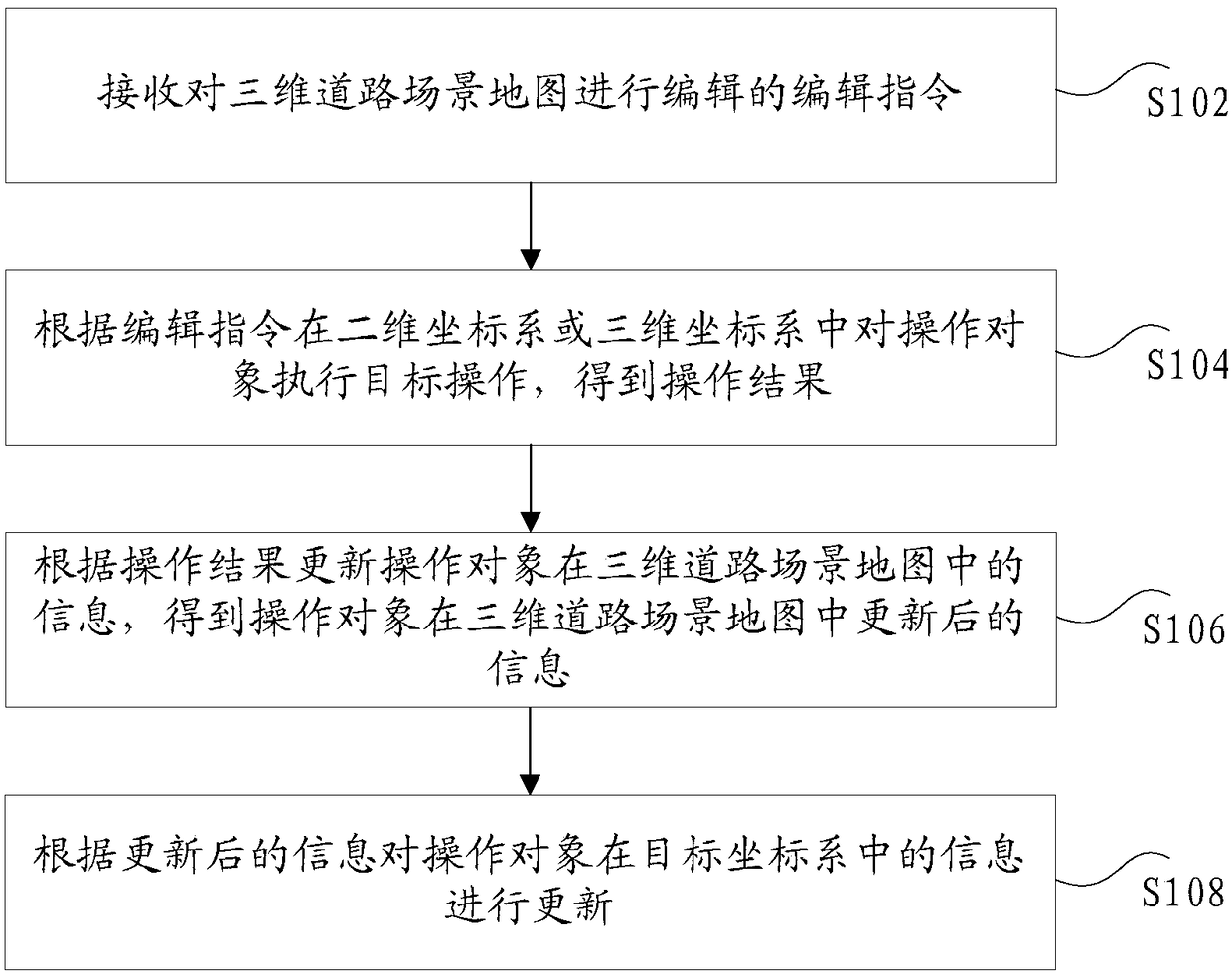
[0018] figure 1 is a flow chart of an optional road scene map construction method according to an embodiment of the present invention, combined below figure 1 The method for constructing the road scene map provided by the embodiment of the present invention is described in detail, such as figure 1 As shown, the construction method of the road scene map mainly includes the following steps S102 to S108:

[0019] Step S102, receiving an editing instruction for edit...

Embodiment 2

[0076] According to an embodiment of the present invention, a road scene map construction device for implementing the above road scene map construction method is also provided. The construction method of the scene map, the following is a specific introduction to the construction device of the road scene map provided by the embodiment of the present invention:

[0077] Figure 4 is a schematic diagram of an optional road scene map construction device according to an embodiment of the present invention, such as Figure 4 As shown, the construction device of the road scene map mainly includes:

[0078] The first receiving unit 410 is configured to receive an editing instruction for editing the vector map data, where the editing instruction is used to instruct to perform a target operation on an operation object in the vector map data.

[0079] When constructing a three-dimensional high-precision road scene map, the high-precision three-dimensional road scene map is more complet...

Embodiment 3

[0105] According to an embodiment of the present invention, a terminal for implementing the above method for constructing a road scene map is also provided, such as Figure 5 As shown, the terminal mainly includes a processor 501, a display 502, a data interface 503, a memory 504 and a network interface 505, wherein:

[0106] The data interface 503 is mainly used for receiving request information for acquiring vector map data and editing instructions for instructing target operations on the vector map.

[0107] The memory 504 is mainly used for storing point cloud data blocks and vector map data.

[0108] The network interface 505 is mainly used for network communication with the server, and obtains point cloud data blocks from the server.

[0109] The display 502 is mainly used to display two-dimensional scenes and three-dimensional scenes and vector map data.

[0110] The processor 501 is mainly used to perform the following operations:

[0111] Receive an editing instructi...


PUM


Abstract

The invention discloses a road scene map building method and device. The method comprises the steps that an editing instruction editing vector map data is received, wherein the editing instruction isused for indicating that target operation is executed on an operation object in the vector map data; the operation object is subjected to target operation in a two-dimensional scene or a three-dimensional scene according to the editing instruction, and an operation result is obtained, wherein coordinates in the two-dimensional scene or the three-dimensional scene has the mapping relation; information of the operation object in the vector map data is updated according to the operation result, updated information of the operation object in the vector map data is obtained; according to the updated information, the information of the operation object in a target scene is updated, wherein the target scene is the scene not executing target operation on the operation object in the three-dimensional scene and the two-dimensional scene. Accordingly, the technical problem that the built road scene map is low in precision is solved.

Description

technical field [0001] The present invention relates to the field of map construction, in particular to a method and device for constructing a road scene map. Background technique [0002] With the development of autonomous driving technology, high-precision maps have gradually become an indispensable part of the entire technical process. High-precision maps can not only provide road scenes with higher absolute accuracy, but also contain rich and detailed road traffic information elements, so as to provide accurate data sources for self-driving vehicles, so that they can accurately judge the surrounding environment and make appropriate driving decisions Strategy. Traditional 3D maps mostly use digital maps as basic data, combined with road image information and field measurement data for artificial construction. Its modeling method is relatively complicated, which requires a lot of manpower and time, and the final road scene has low precision and large human error. At pre...

Claims


Application Information

Patent Timeline
IPC IPC(8): G06F17/30G09B29/00
CPCG06F16/29G06F16/56G09B29/005
Inventor 江旻
Owner TENCENT TECH (SHENZHEN) CO LTD
Why Eureka
Try Eureka