Parcel survey system and method based on unmanned aerial vehicle
A measurement system and unmanned aerial vehicle technology, applied in the agricultural field, can solve the problems of inaccuracy, inability to correct, deviation of plot shape and area, etc., to achieve the effect of improving accuracy
- Summary
- Abstract
- Description
- Claims
- Application Information
AI Technical Summary
Problems solved by technology
Method used
Image
Examples
Embodiment Construction
[0053] In order to make the objectives, technical solutions, and advantages of the present invention clearer, the following further describes the present invention in detail with reference to the accompanying drawings and embodiments. It should be noted that the drawings are only exemplary descriptions and are not drawn to a strict scale, and there may be partial enlargement and reduction for convenience of description, and there may also be certain defaults for known partial structures.
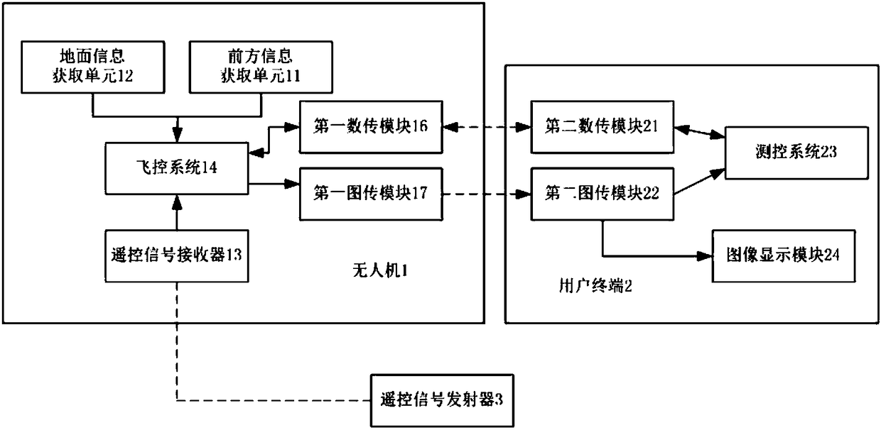
[0054] figure 1 This is a structural block diagram of a UAV-based land parcel measurement system provided by an embodiment of the present invention.
[0055] Such as figure 1 As shown, this embodiment provides a plot measurement system based on drones. The system includes a drone, 1, a user terminal 2, and a remote control signal transmitter 3.
[0056] The UAV 1 is provided with a front information acquisition unit 11, a ground information acquisition unit 12, a positioning module 13, a flight co...
PUM
 Abstract
Description
Claims
Application Information
 - R&D
- Intellectual Property
- Life Sciences
- Materials
- Tech Scout
- Unparalleled Data Quality
- Higher Quality Content
- 60% Fewer Hallucinations
Browse by: Latest US Patents, China's latest patents, Technical Efficacy Thesaurus, Application Domain, Technology Topic, Popular Technical Reports.
© 2025 PatSnap. All rights reserved.Legal|Privacy policy|Modern Slavery Act Transparency Statement|Sitemap|About US| Contact US: help@patsnap.com


