A land parcel measurement system and method based on drones
What is Al technical title?
Al technical title is built by PatSnap Al team. It summarizes the technical point description of the patent document.
A measurement system and unmanned aerial vehicle technology, applied in the agricultural field, can solve problems such as plot shape and area deviation, inaccuracy, lack of plot shape and location data, etc.
Active Publication Date: 2020-07-07
JIAGUTECH CO LTD +1
View PDF5 Cites 0 Cited by
Summary
Abstract
Description
Claims
Application Information
AI Technical Summary
This helps you quickly interpret patents by identifying the three key elements:
Problems solved by technology
Method used
Benefits of technology
Problems solved by technology
Disadvantages: If you deviate from the route, you cannot correct the deviated route, resulting in deviations in the shape and area of the measured plots
[0007] Traditional agricultural surveying only gives an approximate area by measurement and other methods, which is not accurate enough, and there is no more detailed land shape and location data
Method used
Image
Click on the blue label to locate the original text in one second.
Reading with bidirectional positioning of images and text.
Examples
Embodiment Construction
[0053] In order to make the object, technical solution and advantages of the present invention clearer, the present invention will be further described in detail below in conjunction with the accompanying drawings and embodiments. It should be noted that the drawings are only illustrative and not drawn to a strict scale, and there may be partial enlargements and reductions for the convenience of description, and there may be certain omissions for some known structures.
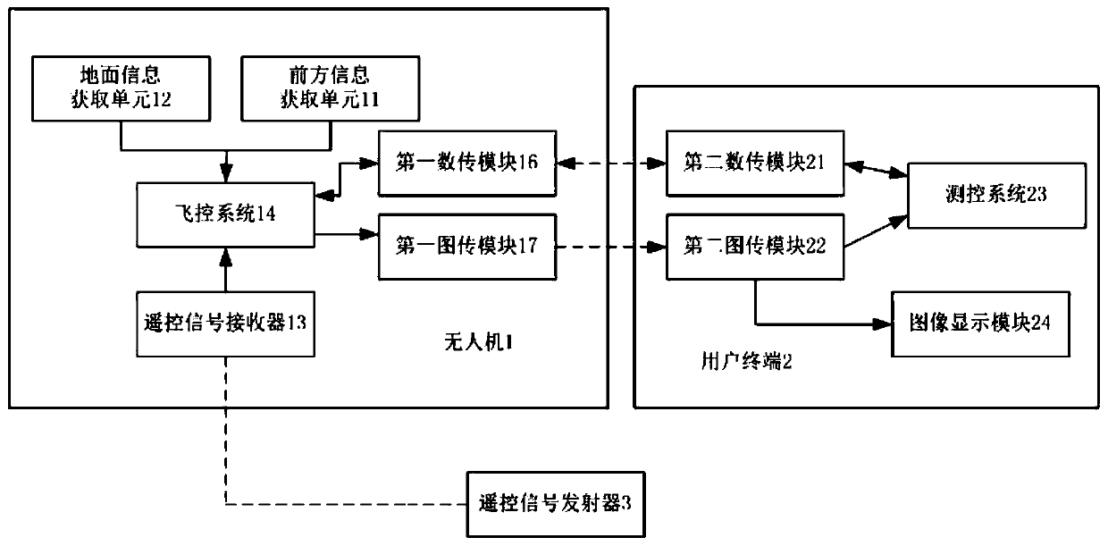
[0054] figure 1 A structural block diagram of an unmanned aerial vehicle-based land plot measurement system provided by an embodiment of the present invention.
[0055] Such as figure 1 As shown, this embodiment provides a drone-based land plot measurement system. The system includes a drone, 1, a user terminal 2 and a remote control signal transmitter 3.
[0056] The UAV 1 is provided with a front information acquisition unit 11 , a ground information acquisition unit 12 , a positioning module 13 , a fligh...
PUM
Abstract
The invention provides a parcel survey system and method based on an unmanned aerial vehicle. The system comprises the unmanned aerial vehicle, a user terminal and a remote control signal transmitter,a flight control system, a front information acquisition unit, a ground information acquisition unit, a positioning module, a first data transmission module, a first image transmission module and a remote control signal receiver are arranged on the unmanned aerial vehicle, the front information acquisition unit, the ground information acquisition unit, the positioning module, the first data transmission module, the first image transmission module and the remote control signal receiver are connected with the flight control system, the remote control signal transmitter is connected with the remote control signal receiver, the user terminal is provided with a measurement and control system, a second data transmission module, a second image transmission module and an image display module, thesecond data transmission module, the second image transmission module and the image display module are connected with the measurement and control system, the image display module is connected with the measurement and control system, and the second data transmission module and the second image transmission module are connected with the first data transmission module and the first image transmission module. The unmanned aerial vehicle for survey replaces manual labor of people, and survey speed is increased. The ground information acquisition unit and the front information acquisition unit areadded to the unmanned aerial vehicle, lower and front view fields of the unmanned aerial vehicle can be simultaneously observed, parcel edges are accurately measured, protection forests can be recognized, and self-security is ensured.
Description
technical field [0001] The invention relates to the field of agricultural technology, in particular to a land plot measurement system and method based on an unmanned aerial vehicle. Background technique [0002] The traditional measurement of rural land plots generally uses methods such as measurement and step measurement. For some irregularly shaped land plots, the area is calculated by filling and cutting, so there are large errors in the area. [0003] With the development of the modern Global Positioning System, mumeters using technologies such as GPS have replaced traditional surveying methods. The hand-held mu meter is an instrument that uses the global positioning system (GPS, Beidou, Galileo, etc.). By collecting the latitude and longitude coordinates of the edge points of the plot, the shape of the plot is obtained and the area of the plot is calculated mathematically. As a measuring tool, the mu meter is suitable for measuring areas such as farmland, green land,...
Claims
Application Information
Patent Timeline
Application Date:The date an application was filed.
Publication Date:The date a patent or application was officially published.
First Publication Date:The earliest publication date of a patent with the same application number.
Issue Date:Publication date of the patent grant document.
PCT Entry Date:The Entry date of PCT National Phase.
Estimated Expiry Date:The statutory expiry date of a patent right according to the Patent Law, and it is the longest term of protection that the patent right can achieve without the termination of the patent right due to other reasons(Term extension factor has been taken into account ).
Invalid Date:Actual expiry date is based on effective date or publication date of legal transaction data of invalid patent.