Eureka AIR delivers breakthrough ideas for toughest innovation challenges, trusted by R&D personnel around the world.

Precision and risk balanced GNSS position service method and system

A risk-balancing, location-based service technology, applied in satellite radio beacon positioning systems, radio wave measurement systems, measurement devices, etc., can solve the problems of limited estimation accuracy, reliability without external benchmarks, and limited number of observations. achieve the effect of ensuring reliability and safety

Active Publication Date: 2018-09-04
QIANXUN SPATIAL INTELLIGENCE INC
View PDF26 Cites 9 Cited by
  • Summary
  • Abstract
  • Description
  • Claims
  • Application Information

AI Technical Summary

Problems solved by technology

[0010] At present, the GNSS terminal can only provide information such as the user's position, speed, and corresponding variance estimation. According to the relevant theories of probability theory, the interval of the true value of the position and the corresponding probability can be calculated. However, in practical applications, due to the variance estimation The reliability of the value is usually not guaranteed, so the risk that the true value is not in the calculated interval cannot be estimated, so there are the following problems:
[0011] 1. The variance of all the parameters involved in the positioning solution in the existing terminal algorithm engine is set according to the empirical model, and its reliability has not been checked by external benchmarks
[0012] 2. The variance of the estimated variance is related to the sample size, and the number of observations participating in the positioning solution is limited each time, and the accuracy of the estimated variance is limited.

Method used


Image

  • Precision and risk balanced GNSS position service method and system
  • Precision and risk balanced GNSS position service method and system
  • Precision and risk balanced GNSS position service method and system

Examples


Embodiment Construction

[0046] The present invention proposes multiple strategies for characterizing the reliability of enhanced content and a set of strategies for eliminating error information of correction numbers received by terminal users. Hereinafter, the present invention will be further described in conjunction with the drawings and embodiments.

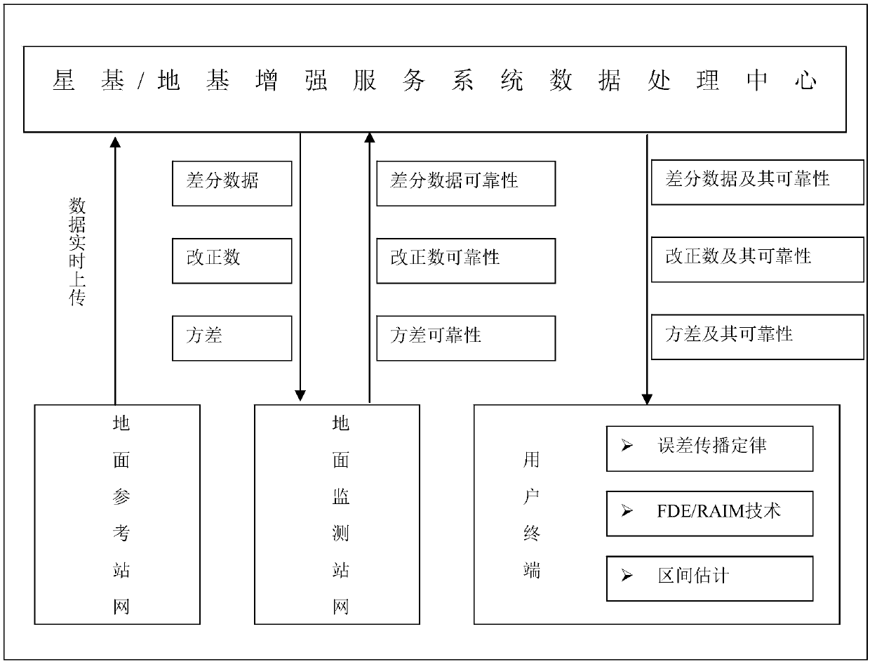
[0047] Such as figure 1 As shown, the present invention includes:

[0048] 1. The ground reference station network, that is, the Continuously Operating Reference Stations (CORS), refers to the ground GNSS tracking station system evenly distributed within the service coverage area, which requires 7*24h continuous operation of each satellite navigation system. Track the observations and upload the data to the satellite-based / ground-based augmentation service system data processing center in real time.

[0049]2. Data processing center of satellite-based / ground-based augmented service system. Process and analyze the data uploaded by the ground refer...


PUM


Abstract

A GNSS terminal can provide information including a user position, speed and corresponding variance estimated value only at present, an interval of a true position value and a corresponding probability can be reckoned according to probability theory related theories, and in piratical application, the reliability of the variance estimated value cannot be ensured, and the risk that the true value isnot within the reckoning interval cannot be pre-estimated. Thus, a satellite-based and ground-based integrated enhanced system scheme and a matched realization strategy of a terminal are provided, position information, a protection interval and corresponding risk can be provided for the user, and a user can make a decision. In addition, the range of the protection interval is intrinsically associated with the risk level, so that different ranges of protection intervals and risks thereof are provided, and the user can make a balance between the precision and risk.

Description

technical field [0001] The invention relates to the technical field of high-precision GNSS satellite positioning, in particular to a method and system for applying GNSS position service with balance of precision and risk. Background technique [0002] 1. GNSS positioning technology [0003] GNSS (Global Navigation Satellite System), including China's Beidou, American GPS, Russia's GLOANASS and Europe's GALILEO, can provide users with all-weather three-dimensional coordinates, speed and time information. By analyzing the electromagnetic wave signal transmitted by the satellite terminal, the terminal can obtain information such as the position of the satellite and the distance between the terminal and the satellite. When 4 or more satellites are observed at the same time, it can realize single-point positioning through simple geometric relationships. [0004] The observations interpreted by the GNSS terminal will be affected by various error sources, mainly including: satelli...

Claims


Application Information

Patent Timeline
Patent Type & Authority Applications(China)
IPC IPC(8): G01S19/23G01S19/40G01S19/41
CPCG01S19/23G01S19/40G01S19/41
Inventor 范国泽蒋智陈亮董冰全
Owner QIANXUN SPATIAL INTELLIGENCE INC
Why Eureka
Eureka Blog
Learn More