Medium-high mountain area airborne gravity measurement three-dimensional route planning method

An aviation gravity and track planning technology, applied in the field of aviation gravity exploration, can solve the problems of weakening effective abnormal information, unfavorable gravity field leveling, large aircraft pitch angle, etc., to reduce false gravity anomalies, reduce average flight height, The effect of ensuring personal safety

Inactive Publication Date: 2018-09-07
中国自然资源航空物探遥感中心
View PDF8 Cites 4 Cited by
  • Summary
  • Abstract
  • Description
  • Claims
  • Application Information

AI Technical Summary

Problems solved by technology

Aviation gravity measurement track planning is usually based on level flight, and level flight aviation gravity measurement is adopted in middle and high mountainous areas (complex mountainous areas with an altitude difference greater than 500m and an altitude greater than 1000m), which leads to an increase in flight altitude and makes the gravimeter data collection The effective anomaly information obtained is greatly weakened, which reduces the accuracy of geological exploration
Zhou Xihua and others theoretically discussed the feasibility and effectiveness of aviation gravity undulating flight in "Research on the Application of Undulating Flight in Aeronautical Gravity Measurement" (Geophysical and Geochemical Exploration, 2015, 39: 98-104), but did not propose Three-dimensional trajectory planning method for flight
At present, aviation gravity fluctuation flight can only be carried out visually. Due to the lack of accurate three-dimensional trajectory planning, first, it is easy to cause the aircraft pitch angle to be too large, resulting in false gravity anomalies, which seriously interfere with the accuracy of the measurement results; second, It is impossible to guarantee that the flying heights at the intersection of the survey line and the cutting line coincide, which is not conducive to the leveling of the gravity field in the whole area

Method used


Image

  • Medium-high mountain area airborne gravity measurement three-dimensional route planning method
  • Medium-high mountain area airborne gravity measurement three-dimensional route planning method

Examples


Embodiment 1

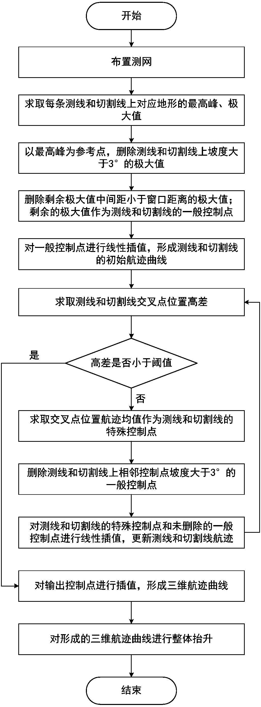
[0016] This embodiment provides a kind of three-dimensional flight path planning method of aerial gravity measurement in high mountainous areas, such as figure 1 shown, including the following steps:

[0017] 1. Collect the topographic data of the survey area, arrange the survey network (including the survey line and the cutting line) according to the requirements of air gravity measurement in the high mountain area, and obtain the horizontal projection coordinates of the survey line and the cutting line.

[0018] 2. Obtain the highest peak and maximum value of the terrain corresponding to each survey line and cutting line. There is only one highest peak, and there are multiple maximum values, and both the highest peak and the maximum value are three-dimensional coordinate values.

[0019] 3. Taking the highest peak as a reference point, delete the maximum value with a slope greater than 3° on the survey line and cutting line. Specifically, a straight line is established wit...

Embodiment 2

[0026] This embodiment provides an initial track curve specifically planned according to the method described in Embodiment 1.

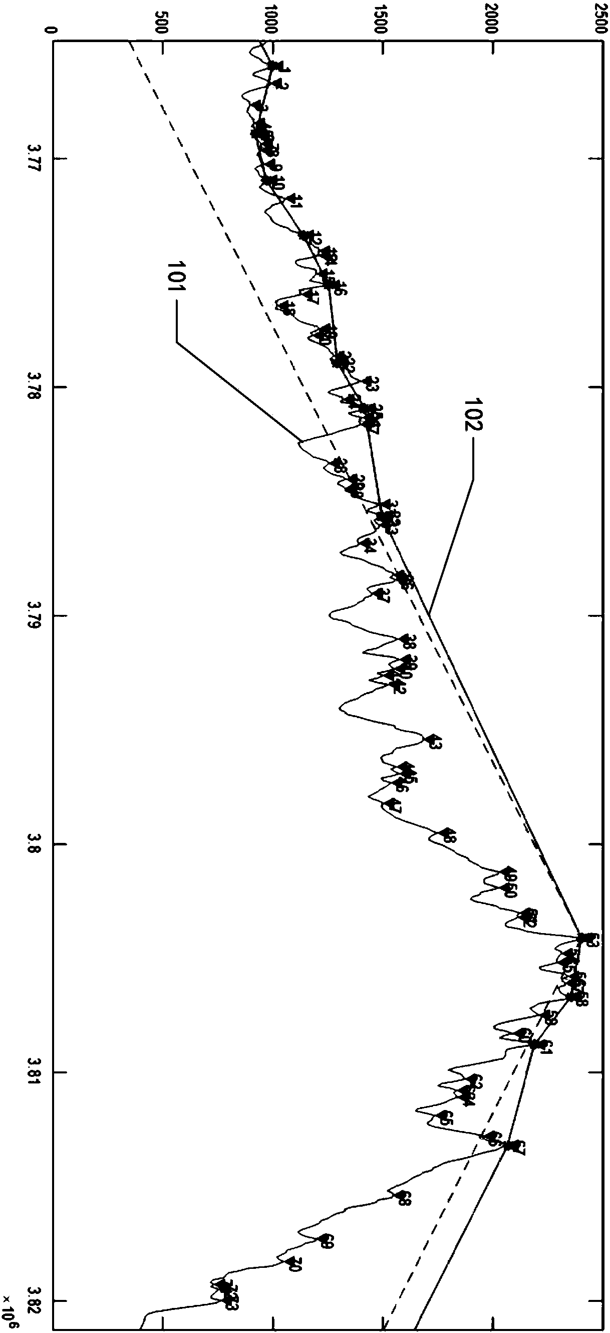
[0027] Such as figure 2 As shown, the abscissa is the projected distance in the extending direction of the measuring line or cutting line, and the ordinate is the height. The first solid line 101 is the contour line of the terrain, and the inverted triangle marks 1-73 are the maximum values ​​on the contour line of the terrain, among which 63 is the highest peak. According to the method described in embodiment 1, at first delete the maximum value whose slope is greater than 3 °, and the remaining maximum value is marked with a circular pattern; then delete the maximum value whose spacing is smaller than the window distance in the remaining maximum value, and the remaining maximum value The maximum value is marked with a *-shaped pattern, which is the general control point; finally, linear interpolation is performed on the general control point, and...


PUM


Abstract

The invention relates to a medium-high mountain area airborne gravity measurement three-dimensional route planning method. According to the requirement of an airborne gravity instrument on the flightfluctuation slope and fluctuation period, the measuring region terrain data is used as the basis; a control point is obtained in a mode of combining the calculation of a maximum value meeting a certain requirement and the calculation of an average value in the cross point of the measuring line and the cutting line; then, the control point is subjected to linear interpolation; the whole is liftedby a certain height to obtain a three-dimensional flight path curve. The average flight height is effectively reduced; the theoretical superposition of the measuring line and the cutting line cross point position height is ensured, so that the gravity field difference value on the cross point is enabled to be possibly small. Meanwhile, the output control point obtained through calculation can be provided for navigation equipment, so that the conventional visual navigation method is broken in the airborne gravity gentle fluctuation slope are enabled to meet the gravity measurement requirements;the problem of virtual gravity abnormality due to too great airplane pitching angle due to artificial factors can be solved.

Description

technical field [0001] The invention belongs to the technical field of aviation gravity exploration, and relates to a three-dimensional track planning method for aviation gravity measurement in middle and high mountainous areas. Background technique [0002] Aeronautical gravimetry is a geophysical method in which airborne gravimeters and other equipment are loaded on aircraft to measure the earth's gravitational field over the measurement area according to a preset flight path. Aviation gravity measurement track planning is usually based on level flight, and level flight aviation gravity measurement is adopted in middle and high mountainous areas (complex mountainous areas with an altitude difference greater than 500m and an altitude greater than 1000m), which leads to an increase in flight altitude and makes the gravimeter data collection The effective anomaly information obtained is greatly weakened, which reduces the accuracy of geological exploration. Zhou Xihua and ot...

Claims


Application Information

Patent Timeline
IPC IPC(8): G01C21/20G01V7/16
CPCG01C21/20G01V7/16
Inventor 李芳闫红雨范正国赵廷严张琦洁王明
Owner 中国自然资源航空物探遥感中心
Why Eureka
Try Eureka