Coastline super-resolution mapping method and coastline super-resolution mapping system based on semi-global optimization

A semi-global optimization and super-resolution technology, applied in image enhancement, image analysis, image data processing, etc., can solve the problems of being unable to adapt to the coastline environment with high curvature and low positioning accuracy

Active Publication Date: 2018-09-18
CHINA UNIV OF GEOSCIENCES (WUHAN)
View PDF6 Cites 14 Cited by
  • Summary
  • Abstract
  • Description
  • Claims
  • Application Information

AI Technical Summary

Problems solved by technology

[0011] Aiming at the shortcomings and deficiencies of the existing technical problems, the present invention provides a coastline super-resolution mapping method and system based

Method used


Image

  • Coastline super-resolution mapping method and coastline super-resolution mapping system based on semi-global optimization
  • Coastline super-resolution mapping method and coastline super-resolution mapping system based on semi-global optimization
  • Coastline super-resolution mapping method and coastline super-resolution mapping system based on semi-global optimization

Examples


Embodiment Construction

[0050] In order to make the objectives, technical solutions and advantages of the present invention clearer, the following further describes the present invention in detail with reference to the accompanying drawings and examples.

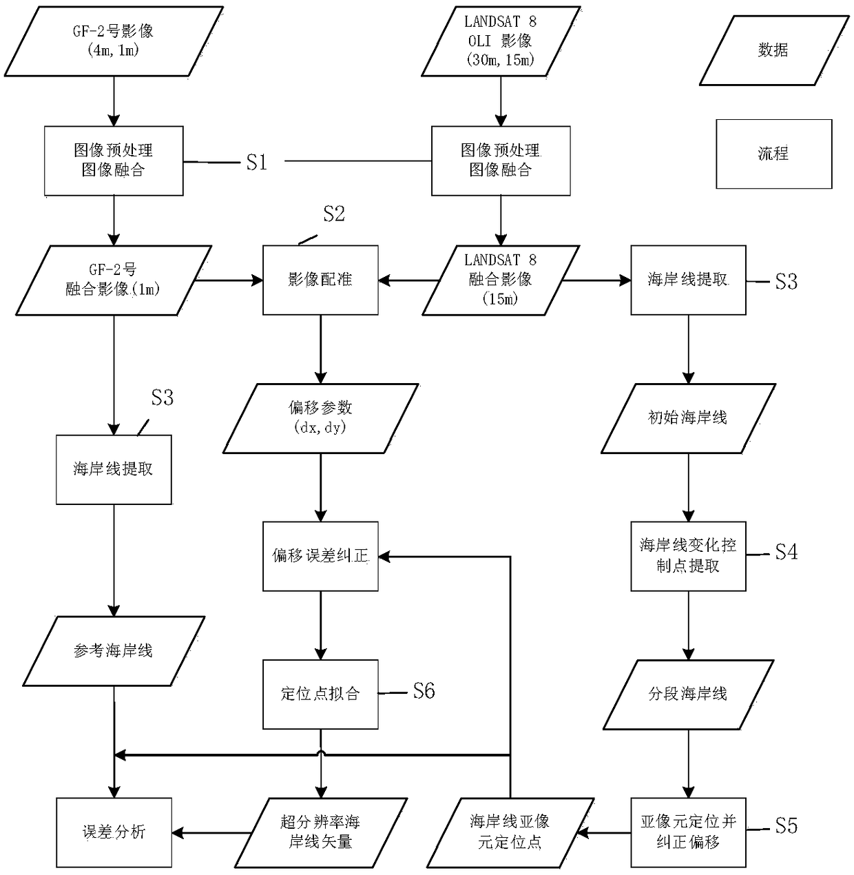
[0051] The present invention proposes a coastline super-resolution mapping method and system based on semi-global optimization. The complete flow chart of the method is shown in figure 1 The study area of ​​the embodiment of the present invention is divided into two parts: Caofeidian Port and the coastal area around Xiamen-Quanzhou. Caofeidian Port is located near 118.5°E, 39°N, adjacent to China's Beijing-Tianjin-Hebei urban agglomeration, and is one of China's important ore transportation ports. Caofeidian used to be just a sand island, which became a port after artificial construction. Therefore, its main coastline type is an artificial coast. The coastline has been stable for a long time and has not been changed for many years. The Xiamen-Quanzhou...


PUM


Abstract

The invention provides a coastline super-resolution mapping method and a coastline super-resolution mapping system based on semi-global optimization. The method mainly comprises the following steps ofacquiring an initial coastline image and a reference image, performing image preprocessing, image fusion and image registration, combining the change trend of an overall coastline form and the gray level change of the periphery of an initial coastline, extracting the change control point of the coastline, and dividing the initial coastline into a plurality of coastline segments; in each of the plurality of coastline segments, acquiring a sub-pixel positioning result in a coastline neighborhood window, and fitting the sub-pixel positioning coordinates of all points in the same section into a smooth curve section; combining all curve segments together to obtain a complete coastline vector result, and completing the super-resolution mapping of the coastline. According to the invention, a sub-pixel positioning method based on a sub-pixel positioning method of a local area and capable of being adapted to a high-curvature coastline environment is provided. The method is high in positioningprecision and can be applied to coastlines with different curvatures. The result accuracy of the method is improved.

Description

Technical field [0001] The invention belongs to the field of coastline image processing, and relates to a coastline super-resolution mapping method and system based on semi-global optimization. Background technique [0002] The coastline is the dividing line between the sea and the land, and is one of the most important 27 surface features. The coastline is affected by natural and man-made factors, resulting in changes in form and nature. Changes in natural conditions such as sea water dynamics (including tidal currents, etc.), geo-meteorological disasters, and sea level rise caused by climate warming have led to coastal silting and erosion; the impact of human activities such as human reclamation, land reclamation, and ocean engineering, At the same time as the coastline type changed, the direction and length of the coastline also changed significantly. [0003] Therefore, coastline mapping and change detection are the basic tasks of coastal erosion monitoring, coastal resource ...

Claims


Application Information

Patent Timeline
IPC IPC(8): G06T11/20G06T3/40G06T5/50G06T7/33G06T7/13
CPCG06T3/4069G06T5/50G06T7/13G06T7/337G06T11/203G06T2207/10032G06T2207/20164G06T2207/20221
Inventor 宋妍刘帆
Owner CHINA UNIV OF GEOSCIENCES (WUHAN)
Why Eureka
Try Eureka