Underwater terrain-aided navigation method based on adaptive sampling particle filter

An adaptive sampling and underwater terrain technology, applied in navigation calculation tools, navigation through speed/acceleration measurement, measurement devices, etc., to achieve the effect of improving the effectiveness and improving the real-time performance of navigation

Inactive Publication Date: 2018-09-21
HARBIN ENG UNIV
View PDF10 Cites 17 Cited by
  • Summary
  • Abstract
  • Description
  • Claims
  • Application Information

AI Technical Summary

Problems solved by technology

[0004] The purpose of the present invention is to provide an underwater terrain-assisted navigation method based on adapt

Method used


Image

  • Underwater terrain-aided navigation method based on adaptive sampling particle filter
  • Underwater terrain-aided navigation method based on adaptive sampling particle filter
  • Underwater terrain-aided navigation method based on adaptive sampling particle filter

Examples


Embodiment Construction

[0040] The present invention will be described in further detail below with reference to the accompanying drawings and specific embodiments.

[0041] combine Figures 1 to 6b , an underwater terrain aided navigation method based on adaptive particle filtering of the present invention, comprising the following steps:

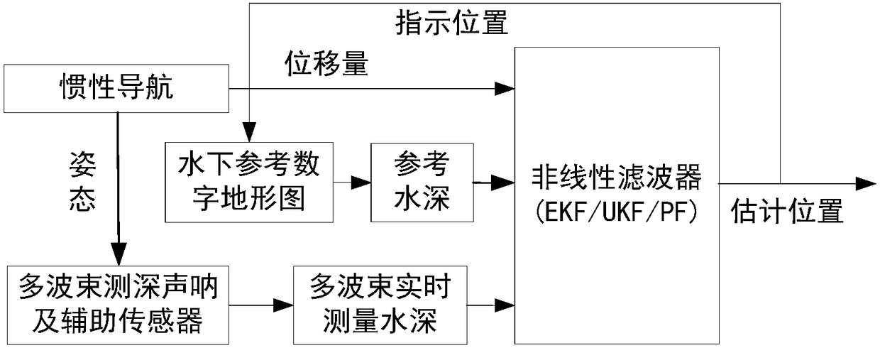
[0042] Step (1) takes the inertial navigation position error as the state, and uses the multi-beam bathymetric sonar as the underwater terrain measurement sensor to establish a state space model and a measurement model of the underwater terrain-assisted navigation;

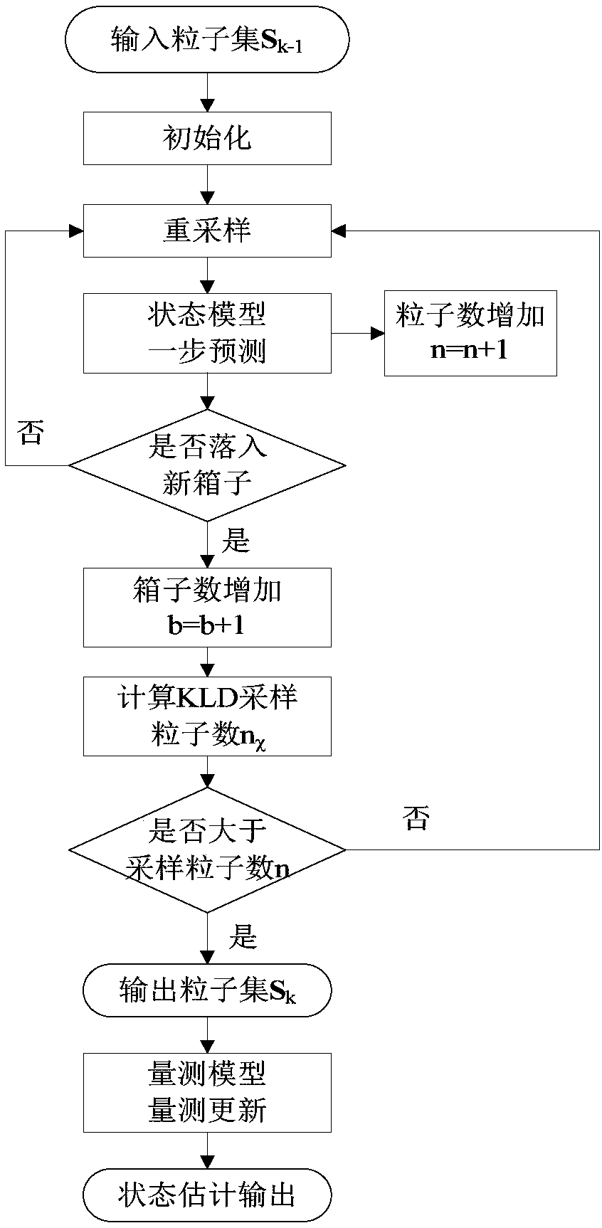
[0043]Step (2) According to the initial position error state distribution, initial particles are generated, and one-step prediction particle update is performed by the state space model to obtain a predicted particle set, and in the one-step prediction particle update process, the KLD sampling technique is used to adjust the number of particles;

[0044] Step (3) When the multi-beam measurement valu...


PUM


Abstract

The invention provides an underwater terrain-aided navigation method based on an adaptive sampling particle filter. The method comprises the steps that a state space model based on an inertial navigation position error and a measurement model based multi-beam depth-sounding sonar are built; one-step predicted particle updating is conducted through initial state distribution and the state space model, the number of particles is adjusted according to predictive state distribution by adopting a KLD sampling technology, and a predicted particle set is obtained; when a multi-beam measured value isreached, the depth, the inertial navigation guiding position and an underwater reference digital map interpolation function are measured in combination with a pressure-depth meter, and particle measurement updating is conducted through the measurement model; finally, by means of the particle set and weight which are obtained after measurement updating is conducted, aircraft position error estimation is conducted by adopting mean squared error minimization rules, and the estimated error is used for correcting the inertial navigation guiding position. Accordingly, the navigation real-time property can be improved while the underwater terrain-aided navigation precision is guaranteed.

Description

technical field [0001] The invention relates to an underwater terrain aided navigation method based on adaptive sampling particle filtering, and belongs to the field of autonomous navigation of underwater vehicles. Background technique [0002] At present, most of the main navigation systems of underwater vehicles are inertial navigation systems (INS). The INS measures the acceleration and attitude through inertial sensors, and determines the speed, position and heading of the underwater vehicle through the integration of time. The INS can independently use the carrier's own equipment for navigation without contacting the outside world, and has the ability to provide navigation information autonomously, continuously and in real time, but it will generate a large cumulative position error when working for a long time. If it is corrected in time, it will likely lead to the failure of the underwater vehicle's mission, and even endanger its own safety. The Global Positioning S...

Claims


Application Information

Patent Timeline
IPC IPC(8): G01C21/16G01C21/20G01C25/00
Inventor 周天彭东东徐超杜伟东王天昊张万远
Owner HARBIN ENG UNIV
Why Eureka
Try Eureka