Highway geological disaster risk assessment method

A geological disaster and risk technology, applied in the fields of instrument, character and pattern recognition, data processing application, etc., can solve the problems of long route mileage, inability to meet the requirements of rapid identification and quantitative analysis of geological disasters, and lack of quantitative analysis methods for remote sensing information. , to achieve the effect of small loss, favorable for geological line selection and high reliability

Inactive Publication Date: 2018-09-28
CHINA ROAD & BRIDGE
View PDF5 Cites 10 Cited by
  • Summary
  • Abstract
  • Description
  • Claims
  • Application Information

AI Technical Summary

Problems solved by technology

[0004] As a linear traffic project, highway engineering has a long route, spans different geological and geomorphic units, and has a complex geological environment. Geological remote sensing interpretation is often used supplemented by traditional ground survey methods. Remote sensing technology has the ability to perform dynamic observations macroscopically, accurately, and comprehensi

Method used


Image

  • Highway geological disaster risk assessment method
  • Highway geological disaster risk assessment method
  • Highway geological disaster risk assessment method

Examples


Embodiment Construction

[0053]The following will clearly and completely describe the technical solutions in the embodiments of the present invention with reference to the accompanying drawings in the embodiments of the present invention. Obviously, the described embodiments are only some, not all, embodiments of the present invention. Based on the embodiments of the present invention, all other embodiments obtained by persons of ordinary skill in the art without making creative efforts belong to the protection scope of the present invention.

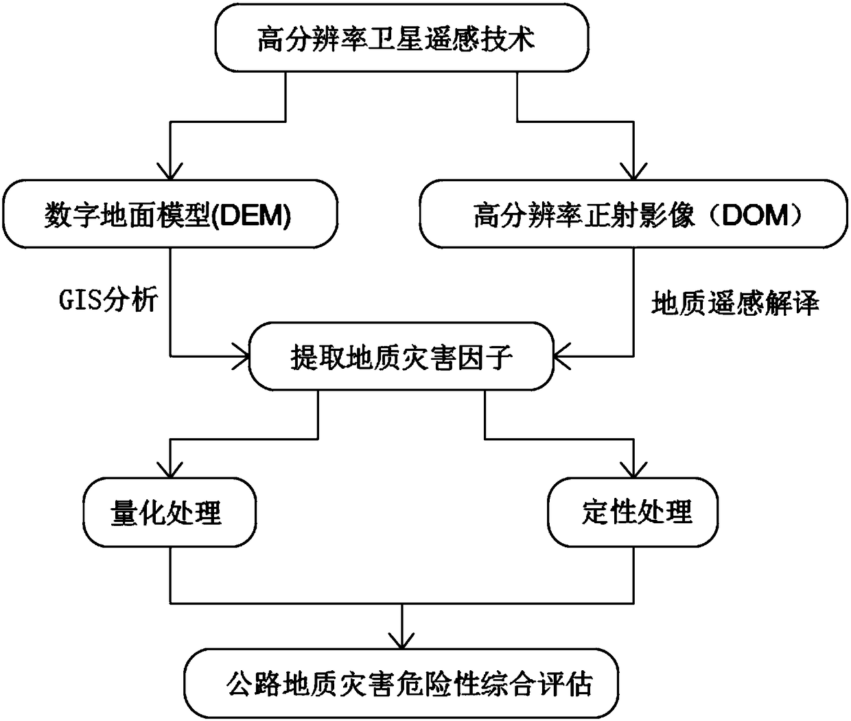
[0054] Such as figure 1 Shown, the present invention provides a kind of highway geological disaster risk assessment method, comprises the following steps:

[0055] Step S100, based on high-resolution satellite remote sensing technology, establish digital terrain models (DEM) for several areas, and generate high-resolution orthophotos (DOM) for several areas, record and store remote sensing information data of different areas, and extract each Regional geologic...


PUM


Abstract

The invention discloses a highway geological disaster risk assessment method, including the following steps: step S100, establishing a plurality of regional digital elevation models (DEM) based on a high-resolution satellite remote sensing technology, simultaneously generating high-resolution digital orthophoto maps (DOM) of a plurality of regions, recording and storing remote sensing informationdata of different regions, and extracting geological disaster factors of each region; step S200, performing quantitative statistical analysis on the geological disaster factors in the step S100; and step S300, adopting two different data processing methods for the quantitative statistical analysis described in the step S200, including quantitative processing and qualitative processing. Thereby, the quantitative expression of highway geological disaster risks can be realized, high-resolution satellite stereo image data is adopted to perform remote sensing identification and qualitative analysis, automatic information extraction and quantitative statistical analysis on highway geological disasters such as landslides and collapse, and thus the function of accurately and efficiently assessingthe highway geological disaster risks can be realized.

Description

technical field [0001] The invention relates to the technical field of road geological disaster risk assessment, in particular to a road geological disaster risk assessment method. Background technique [0002] Road geological disasters such as landslides and collapses seriously threaten the safety of human life and property. With the rapid improvement of the national road network in mountainous areas and central and western regions, various sudden geological disasters often cause devastating damage to road transportation infrastructure, resulting in Due to the huge loss of national property and people's lives, and heavy damage to the regional economy and ecological environment, it is very important to carry out geological disaster risk assessment in the whole life cycle of road projects to realize the prevention and mitigation of geological disasters in road traffic. [0003] At present, the risk assessment of geological disasters is mainly based on ground work such as data...

Claims


Application Information

Patent Timeline
IPC IPC(8): G06Q10/06G06K9/00
CPCG06Q10/0635G06Q10/0639G06V20/182
Inventor 陈凯
Owner CHINA ROAD & BRIDGE
Why Eureka
Try Eureka