Multi-level building rapid three-dimensional reconstruction method based on laser radar point cloud

A laser radar and 3D reconstruction technology, applied in 3D modeling, instrumentation, computing, etc., can solve the problem of large amount of data, achieve the effects of suppressing interference, high execution efficiency, and reducing the generation of false key points

Pending Publication Date: 2018-11-06
HOHAI UNIV
View PDF3 Cites 11 Cited by
  • Summary
  • Abstract
  • Description
  • Claims
  • Application Information

AI Technical Summary

Problems solved by technology

The amount of LIDAR point cloud data is large. Although many methods have been proposed at home and abroad to reconstruct buildings, there is still a lot of room for improvement in the reconstruction efficiency of 3D reconstruction of buildings.

Method used


Image

  • Multi-level building rapid three-dimensional reconstruction method based on laser radar point cloud

Examples


Embodiment Construction

[0021] The present invention will be further described below in conjunction with accompanying drawing.

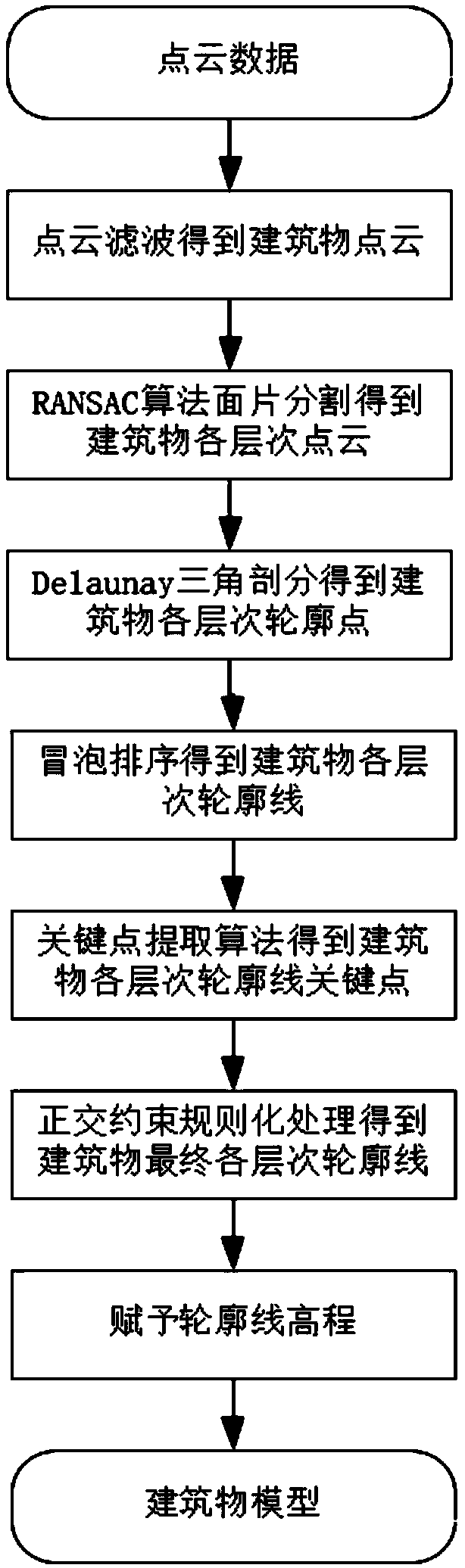
[0022] Such as figure 1 Shown, the present invention comprises the following steps:

[0023] (1) According to the requirements of the final product, set appropriate parameters (such as scanning frequency, flight height, etc.), use the airborne lidar system to collect three-dimensional space data of the target area, and obtain the original point cloud data.

[0024] (2) Filter the point cloud data to obtain building point cloud data.

[0025] (3) Use the optimized random sampling consensus algorithm to set the number of cycles, the minimum number of internal points and the distance threshold. Generally, the number of cycles is determined according to the number of building point sets; the minimum number of internal points is generally 50. When it is 50, it is not regarded as a plane; the distance threshold is determined according to the accuracy of the laser point cloud, g...


PUM


Abstract

The invention discloses a multi-level building rapid three-dimensional reconstruction method based on laser radar point cloud. The method comprises steps of: collecting three-dimensional point cloud data; performing point cloud filtering processing to obtain building point cloud; using an optimized random sampling consistency algorithm to obtain a laser point cloud set; performing Delaunay triangulation to extract the contour points of a building; performing bubble sorting to sort the contour points to generate contour lines; using a key point extraction algorithm to extract key points of a building outline; connecting the key points, and using the orthogonal constraint to regularize the contour lines; and assigning elevation information in the point cloud to the building outline to generate a three-dimensional building model. The method adopts an optimized algorithm to provide higher execution efficiency and can effectively delete building wall points; the Delaunay subdivision methodis used to accurately extract the building outline; and the contour line key point extraction algorithm is used to better extract the key points of the building, and can suppress the interference of the wrong contour points and reduce the generation of pseudo key points.

Description

technical field [0001] The invention belongs to the technical field of using laser radar for surveying and mapping, in particular to a fast three-dimensional reconstruction method for multi-level buildings based on laser radar point clouds. Background technique [0002] With the advent of the information age, the demand for digital city construction is increasingly urgent. People not only hope to obtain rich 3D real map information to facilitate life and travel, but also hope to establish a 3D landscape model of the entire city for urban planning, traffic management, disaster emergency response, environmental protection and other work. Buildings are the basic elements of constructing urban landscape environment, and their automatic modeling has been the focus and difficulty of research in the past two decades. [0003] Through the integration of high-speed laser scanning ranging, high-precision dynamic carrier attitude measurement and high-precision dynamic GPS differential...

Claims


Application Information

Patent Timeline
Patent Type & Authority Applications(China)
IPC IPC(8): G06T17/10
CPCG06T17/10
Inventor 周嘉俊李勇雍斌任立良张晓祥方秀琴何明
Owner HOHAI UNIV
Why Eureka
Try Eureka