Unmanned aerial vehicle ribbon-shaped slanted image aerial survey method and system

A tilting image and UAV technology, applied in the field of UAV aerial survey, can solve the problems of inconvenient operation, increase of redundant data and data processing workload, etc., to reduce complexity, improve data collection efficiency and data processing efficiency , easy to adjust the effect

Active Publication Date: 2018-11-23
广州中科云图智能科技有限公司
View PDF13 Cites 35 Cited by
  • Summary
  • Abstract
  • Description
  • Claims
  • Application Information

AI Technical Summary

Problems solved by technology

[0003] At present, when conducting aerial surveys by UAVs, a rectangular or irregular polygonal area is usually generated first, and then the route is planned by adjusting the control points on the area. ...

Method used


Image

  • Unmanned aerial vehicle ribbon-shaped slanted image aerial survey method and system
  • Unmanned aerial vehicle ribbon-shaped slanted image aerial survey method and system
  • Unmanned aerial vehicle ribbon-shaped slanted image aerial survey method and system

Examples


Embodiment Construction

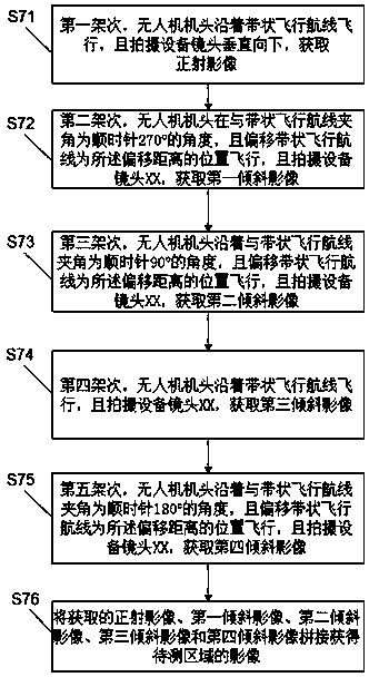
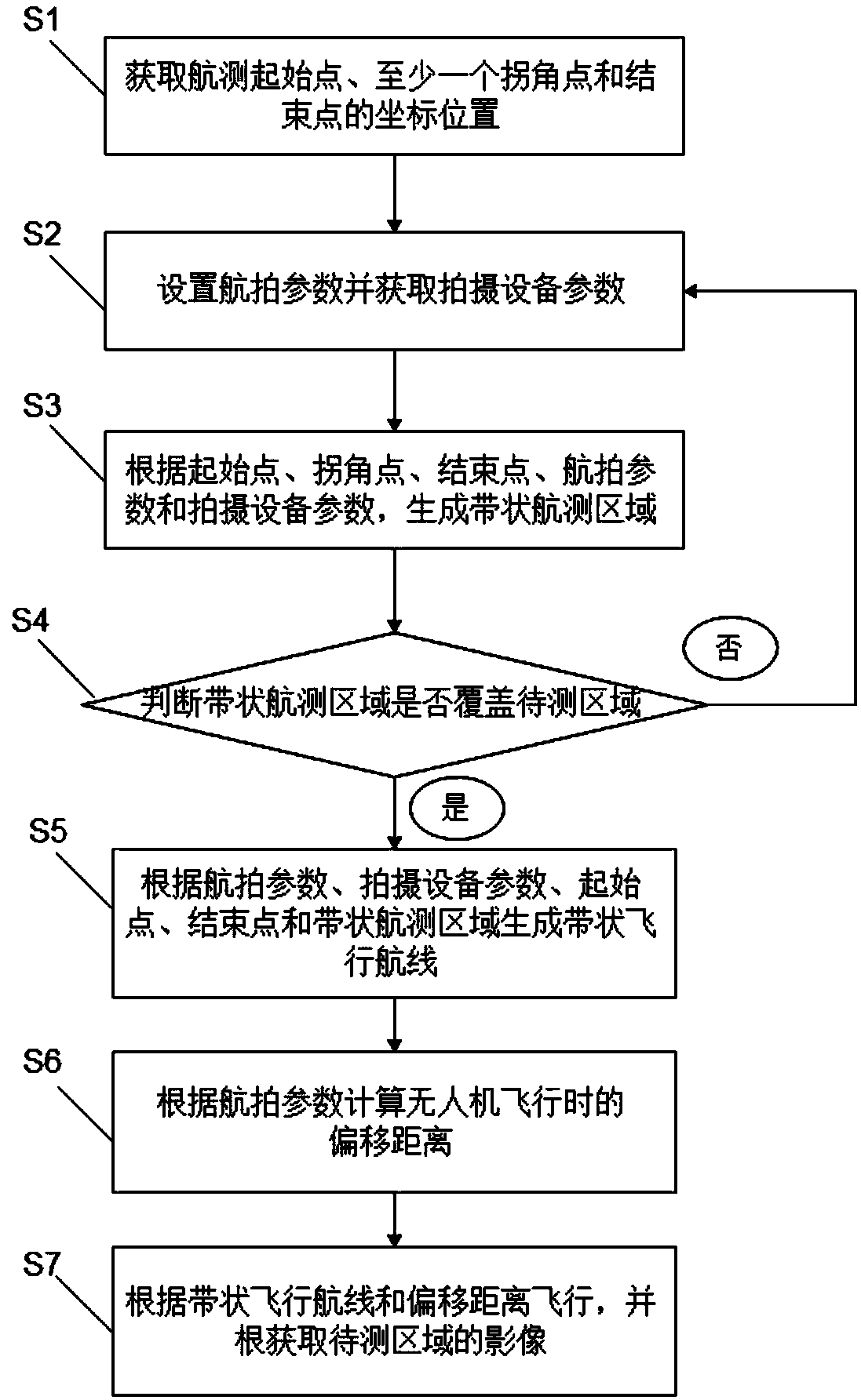
[0043] Please also see figure 1 and figure 2 , figure 1 It is a flow chart of the method for aerial surveying of unmanned aerial vehicles with oblique images in the embodiment of the present invention; figure 2 It is the UAV strip oblique image route map in the embodiment of the present invention. The method for aerial surveying of the unmanned aerial vehicle strip-shaped oblique image comprises the following steps:

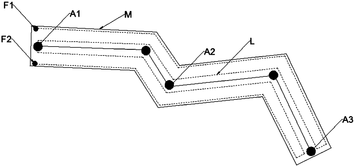
[0044] Step S1: Obtain the position coordinates of the starting point A1, at least one corner point A2 and the ending point A3 of the aerial survey.

[0045] In one embodiment, each point can be selected by manually clicking on the map, and the position coordinates of the start point A1, at least one corner point A2, and the end point A3 can be obtained by obtaining the position of the hand click on the map.

[0046] In one embodiment, in order to accurately obtain the position coordinates of the start point A1, at least one corner point A2, and the end poi...


PUM


Abstract

The invention relates to an unmanned aerial vehicle ribbon-shaped slanted image aerial survey method and system. The unmanned aerial vehicle ribbon-shaped slanted image aerial survey method comprisesthe following steps: acquiring coordinate positions of an aerial survey start point, a corner point and an end point; setting aerial survey parameters and acquiring parameters of a photographing device; generating a ribbon-shaped aerial survey area; determining whether the ribbon-shaped aerial survey area covers a to-be-detected area, and if yes, generating a ribbon-shaped flight route according to the aerial survey parameters, the parameters of the photographing device, the start point, the end point and the ribbon-shaped aerial survey area; and flying according to the ribbon-shaped flight route and a deviation distance, and acquiring an image of the to-be-detected area. As long as the aerial survey parameters are manually set, the ribbon-shaped aerial survey area conforming to the to-be-detected area and the unmanned aerial vehicle flight ribbon-shaped route can be generated, so that the unmanned aerial vehicle can flight according to the set ribbon-shaped route, the complexity of the manual operation can be alleviated, and the data acquisition efficiency and the data processing efficiency can be improved.

Description

technical field [0001] The invention relates to the field of unmanned aerial vehicle survey, in particular to a method and system for aerial survey of unmanned aerial vehicle belt oblique images. Background technique [0002] UAV aerial survey is to obtain aerial photographic images through the inspection of the survey area by the drone equipped with photographic equipment. This method can not only obtain the image data in real time, obtain the real-time situation of the survey area, but also intercept the image data to splicing the image data. Quickly acquire images of the entire survey area, featuring flexible maneuverability, high efficiency and speed, precision and accuracy, low operating costs, wide application range, and short production cycle, etc. It has been widely used in the rapid acquisition of high-resolution images in small areas and areas with difficult flying . [0003] At present, when conducting aerial surveys by UAVs, a rectangular or irregular polygonal ...

Claims


Application Information

Patent Timeline
IPC IPC(8): G01C11/02G05D1/10
CPCG01C11/02G05D1/101
Inventor 杨骥潘屹峰李勇何永辉
Owner 广州中科云图智能科技有限公司
Why Eureka
Try Eureka