Remote sensing surface temperature spatial downscaling method based on normalized desert indexes

A surface temperature and downscaling technology, applied in the downscaling field, can solve the problems of low accuracy, lack of remote sensing index, and inability to meet the application, and achieve the effect of improving downscaling accuracy and good applicability

Active Publication Date: 2018-11-27
HOHAI UNIV
View PDF5 Cites 16 Cited by
  • Summary
  • Abstract
  • Description
  • Claims
  • Application Information

AI Technical Summary

Problems solved by technology

However, there is still a lack of corresponding remote sensing indices for the downscaling research on the desert surface in arid areas, and the existing remote sensing factors are not sensitive enough to the spectral characteristics of deserts, so it is difficult to distinguish deserts from other land objects, and the tem...

Method used


Image

  • Remote sensing surface temperature spatial downscaling method based on normalized desert indexes
  • Remote sensing surface temperature spatial downscaling method based on normalized desert indexes
  • Remote sensing surface temperature spatial downscaling method based on normalized desert indexes

Examples


Embodiment Construction

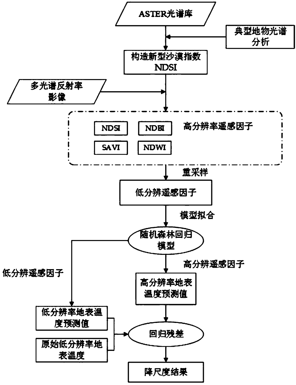
[0030] The spatial downscaling method of remotely sensed surface temperature based on normalized desert index includes the following steps:

[0031] Step 1: Obtain remote sensing data and preprocessing. Obtain multispectral and thermal infrared remote sensing images covering the study area under clear sky conditions, and perform preprocessing. The preprocessing used mainly includes image correction, cropping, resampling and other operations. The multispectral and thermal infrared images of the original remote sensing images are corrected, and the preprocessed multispectral reflectance images are resampled to the same resolution as the thermal infrared remote sensing images, and are uniformly cropped to the same research area.

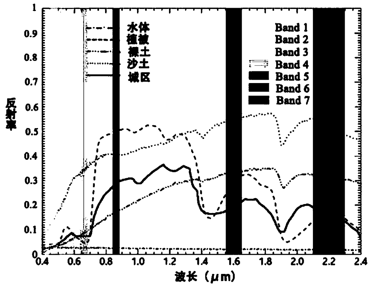
[0032] Step 2: Construct a new type of remote sensing desert index - the normalized normalized desert index NDSI. The remote sensing index is derived from the combination of single or multiple visible near-infrared bands and short-wave infrared bands....


PUM


Abstract

The invention discloses a remote sensing surface temperature spatial downscaling method based on normalized desert indexes. The method comprises the following steps: a, acquiring a multi-spectrum andthermal infrared remote sensing image which covers the range of a research area under a sunny condition, and preprocessing; b, upscaling a multi-spectral reflectivity image and a thermal infrared image to the same low resolution through a polymerization method, and constructing a new drought index according to the multi-spectral reflectivity image to represent the desert surface; c, carrying out temperature inversion on the preprocessed thermal infrared remote sensing image to obtain the surface temperature in the research area; d, taking a novel drought index, vegetation index, building indexand water body index as scale factors, establishing an earth surface temperature downscaling model with a random forest regression algorithm, and obtaining a high-resolution earth surface temperatureimage of the research area through the model; e, carrying out precision evaluation on the dimension reduction result. The method is beneficial for improving the dimension reduction precision in the desert area.

Description

technical field [0001] The invention relates to the field of downscaling, in particular to a space downscaling method for remote sensing surface temperature based on a normalized desert index. Background technique [0002] Surface temperature is the direct driving force of long-wave radiation and turbulent heat flux exchange at the surface-atmosphere interface, and is an important indicator for describing the physical exchange process of surface energy and studying climate change on a global scale. Accurate surface temperature products are of great significance for monitoring urban heat islands, ecological environment, agricultural drought, monitoring global climate, estimating soil moisture and other surface processes. The traditional way to obtain surface temperature is through the observation data of surface meteorological stations. The observation station data has high precision and time continuity, but the monitoring coverage area is limited, which is not suitable for l...

Claims


Application Information

Patent Timeline
IPC IPC(8): G01J5/00
CPCG01J5/007G01J2005/0077G01J5/80
Inventor 潘鑫杨英宝曹晨朱熹胡佳王爱辉
Owner HOHAI UNIV
Why Eureka
Try Eureka