Object-level classification sample automatic selection method for collaborative change detection

A technology of automatic selection and change detection, applied in the field of remote sensing, can solve the problems of high labor and material cost, and achieve the effect of improving efficiency and speed

Inactive Publication Date: 2018-11-30
SUZHOU ZHONGKE IMAGE SKY REMOTE SENSING TECH CO LTD +2
View PDF1 Cites 4 Cited by
  • Summary
  • Abstract
  • Description
  • Claims
  • Application Information

AI Technical Summary

Problems solved by technology

A prerequisite for the effective application of this method is that there are a large number of object-level samples. However, if the samples are collected and selected repeatedly when classifying each phase of images, it will consume a lot of manpower and material costs. This is the current method of object-level classification. Bottleneck problems encountered in long-term application in large areas

Method used


Image

  • Object-level classification sample automatic selection method for collaborative change detection
  • Object-level classification sample automatic selection method for collaborative change detection
  • Object-level classification sample automatic selection method for collaborative change detection

Examples


Embodiment 1

[0030] The main idea of ​​the present invention is to find the "unchanged" ground objects on the two-phase remote sensing images, and based on this, establish the mapping relationship between the "unchanged" regions between the two phases of images, and use the mapping relationship to convert the previous image The sample information is migrated to the new image to realize the automatic migration and reuse of samples at different times.

[0031] The premise of the present invention is to obtain two phases of remote sensing images of the same research area, and the two phases of images are required to have similar spectral and spatial resolutions, that is, the optimal solution is that the two phases of images come from the same sensor, and the previous auxiliary remote sensing images have corresponding The sample or classification result information of . Specific steps are as follows:

[0032] 1) Multi-scale segmentation is performed on the image of the new time phase by means...

Embodiment 2

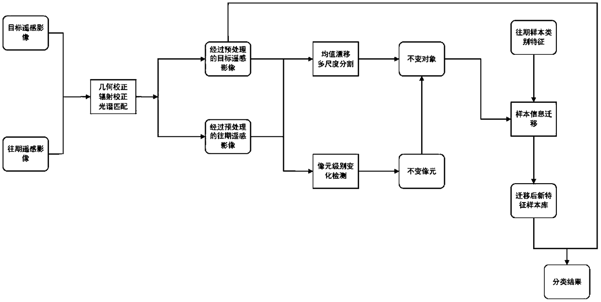
[0046] figure 1The main realization idea of ​​the present invention is illustrated. The key steps of the present invention include mutual matching between remote sensing images, including spatial geometry matching and spectral radiation matching; multi-scale segmentation of new time-phase remote sensing images using the mean value shift method to extract ground objects; image matching between different time-phase images Meta-level change detection, using the spatial position relationship between "unchanged" pixels to establish the mapping of sample information between images; using the established mapping relationship to migrate sample class labels; The sample information migrated on the pixel constructs the "invariant" object and its sample label; the object sample of the new image is purified by setting a threshold, and the wrong sample is eliminated, and finally more reliable new sample data is obtained for subsequent classification. training process.

[0047] figure 2 ...

Embodiment 3

[0062] Taking the two phases of SPOT5 in Dongguan City as the test images, the automatic selection of samples was carried out through the method of the present invention, and the effect is as follows Figure 4 shown. It can be seen that new object-level samples have been established for garden land, grassland, construction land, water area, cultivated land, and wasteland in the image. Model training and automatic classification of ground objects can be carried out on the basis of sample establishment. The results are as follows: Figure 5 shown. After verification, its user accuracy is as follows: 89.6% for cultivated land, 92.6% for garden land, 68.91% for grassland, 59.1% for construction land, 69.2% for water area, 53.3% for wasteland, the overall accuracy is 80.6%, and the kappa coefficient is 0.7379. In this automatic sample selection process, manual visual collection is not relied on, and the accuracy of subsequent classification results based on automatically collecte...


PUM


Abstract

The invention discloses an object-level classification sample automatic selection method for a remote sensing image and enabling collaborative change detection. The method includes: using the uniformdrifting method to perform multi-scale segmentation on an image of a new time phase under the premise of acquiring two remote sensing images in the same region, acquiring object boundary information of a surface feature, performing change detection on the two images, and obtaining an invariant pixel; establishing an "invariant" information mapping relationship between the two images on the basis of a position of the invariant pixel, and performing migration of original sample information at the corresponding "invariant" position; using a vector boundary obtained by the new time phase image segmentation as a constraint, and extracting an "invariant" object and sample class label information thereof; and finally using an object correlation attribute to perform sample purification, eliminating a part of objects with error class label information, and finally establishing an object-level sample library of the new image which is used for the classification of new time phase remote sensing images.

Description

technical field [0001] The invention relates to the technical field of remote sensing, in particular to a method for automatically selecting samples for object-level classification of remote sensing images through cooperative change detection. Background technique [0002] Remote sensing can quickly obtain large-scale surface data. In the application of remote sensing images, classification is still the most basic and core problem. Although there are many relatively mature classification algorithms, the problems of classification accuracy and speed have not been well resolved. The early manual visual interpretation classification method has the disadvantage of consuming a lot of manpower and time. With the development of computer technology, the advantages of machine classification methods have gradually emerged. Among them, the early pixel-level classification methods have been widely used in medium and low spatial resolution remote sensing images, which has promoted the a...

Claims


Application Information

Patent Timeline
Patent Type & Authority Applications(China)
IPC IPC(8): G06K9/00G06K9/34G06K9/38G06K9/62
CPCG06V20/13G06V10/28G06V10/267G06F18/24
Inventor 吴田军胡晓东夏列钢骆剑承董文
Owner SUZHOU ZHONGKE IMAGE SKY REMOTE SENSING TECH CO LTD
Why Eureka
Try Eureka