
A method and a device for solving laser radar point cloud data

A technology of point cloud data and laser radar, which is applied in the field of calculation methods and devices for laser radar point cloud data, can solve the problems of inconsistent output format of point cloud data, difficult calculation, complicated operation process, etc., and achieve easy calculation and use, and improve The effect of solution speed

Active Publication Date: 2018-12-07
BEIJING GREEN VALLEY TECH CO LTD
View PDF11 Cites 19 Cited by
  • Summary
  • Abstract
  • Description
  • Claims
  • Application Information

AI Technical Summary

Problems solved by technology

However, in some areas there are many types of ground objects, and a single type of laser scanner can no longer meet the requirements of acquisition accuracy. Therefore, it is necessary to mount multiple types of laser scanners on the carrier platform. The point cloud data collected by the type laser scanner is divided into each calculation device equipped with its own calculation algorithm, and each calculation device performs calculation processing on the point cloud data of its matching type
[0004] In the process of solving the above-mentioned multi-type point cloud data, it is necessary to manually separate different types of point cloud data to the corresponding interpretation equipment, the operation process is complicated and the calculation speed is slow. The output format of cloud data is inconsistent, and it is not easy for subsequent calculations

Method used


Image

  • A method and a device for solving laser radar point cloud data
  • A method and a device for solving laser radar point cloud data
  • A method and a device for solving laser radar point cloud data

Examples


Embodiment Construction

[0051] In order to make the purpose, technical solutions and advantages of the embodiments of the present application clearer, the technical solutions in the embodiments of the present application will be clearly and completely described below in conjunction with the drawings in the embodiments of the present application. Obviously, the described embodiments are only It is a part of the embodiments of this application, not all of them. The components of the embodiments of the application generally described and illustrated in the figures herein may be arranged and designed in a variety of different configurations. Accordingly, the following detailed description of the embodiments of the application provided in the accompanying drawings is not intended to limit the scope of the claimed application, but merely represents selected embodiments of the application. Based on the embodiments of the present application, all other embodiments obtained by those skilled in the art without...


PUM


Abstract

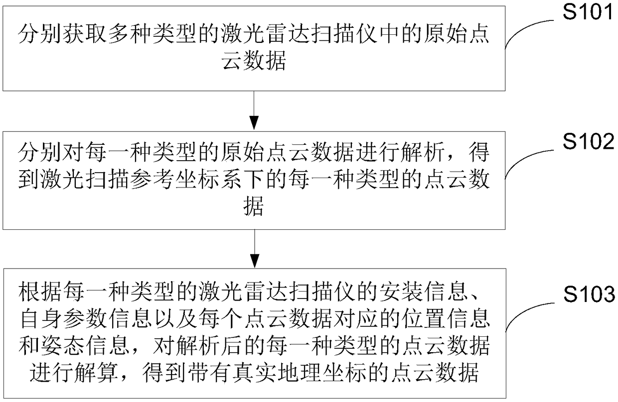
The present application provides a method and a device for solving laser radar point cloud data, which relate to the technical field of laser radar detection. The method comprises the following steps:obtaining original point cloud data in a plurality of types of laser radar scanners; analyzing the original point cloud data of each type separately to obtain the point cloud data of each type in the laser scanning reference coordinate system; according to the installation information of each type of laser radar scanner, its own parameter information and the corresponding position information and attitude information of each point cloud data, solving the point cloud data of each type after parsing obtain the point cloud data with real geographical coordinates. In this way, the point cloud data of various types of laser radar scanners can be automatically calculated by one device, the steps of distinguishing different types of point cloud data are not needed, the speed of calculation is improved, and each type of point cloud data is output based on a unified format, so that the subsequent calculation is easy.

Description

technical field [0001] The present application relates to the technical field of laser radar detection, in particular, to a method and device for solving laser radar point cloud data. Background technique [0002] Airborne laser scanning (Light Detection And Ranging, LIDAR) technology emerged in the late 1990s. It uses laser ranging and Global Positioning System (Global Positioning System, GPS) positioning principles to quickly obtain high-precision three-dimensional Coordinate points. [0003] At present, a type of laser scanner is usually mounted on the carrier platform, and the point cloud data on the ground object is collected through this type of laser scanner, and then based on the calculation algorithm that matches this type of laser scanner, the The collected point cloud data is calculated to obtain high-precision three-dimensional coordinate points on the ground object. However, some areas have many types of ground objects, and a single type of laser scanner can n...

Claims


Application Information

Patent Timeline
Patent Type & Authority Applications(China)
IPC IPC(8): G06F17/10
CPCG06F17/10
Inventor 郭彦明
Owner BEIJING GREEN VALLEY TECH CO LTD
Learn More