Calculation method, device and multi-thread processing system for lidar point cloud data

A point cloud data and lidar technology, applied in electrical digital data processing, radio wave measurement systems, measurement devices, etc., can solve the problems of slow point cloud data calculation speed and high computer hardware requirements, saving calculation time, The effect of increasing the solving speed

Active Publication Date: 2020-11-24
BEIJING GREEN VALLEY TECH CO LTD
View PDF5 Cites 2 Cited by
  • Summary
  • Abstract
  • Description
  • Claims
  • Application Information

AI Technical Summary

Problems solved by technology

[0005] The main purpose of the present invention is to provide a method, device and multi-threaded processing system for lidar point cloud data, aiming to solve the problems of slow point cloud data calculation speed and high requirements for computer hardware in the prior art

Method used


Image

  • Calculation method, device and multi-thread processing system for lidar point cloud data
  • Calculation method, device and multi-thread processing system for lidar point cloud data
  • Calculation method, device and multi-thread processing system for lidar point cloud data

Examples


Embodiment Construction

[0048] It should be understood that the specific embodiments described here are only used to explain the present invention, not to limit the present invention.

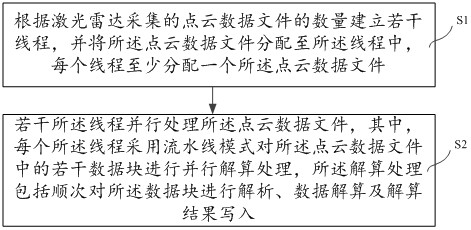
[0049] see figure 1 , this embodiment provides a method for solving lidar point cloud data, including:

[0050] Step S1: Establish several threads according to the number of point cloud data files collected by the lidar, and assign the point cloud data files to the threads, each thread assigning at least one point cloud data file;

[0051] Step S2: Several of the threads process the point cloud data file in parallel, wherein each of the threads uses a pipeline mode to perform parallel calculation processing on several data blocks in the point cloud data file, and the calculation processing includes Perform parsing, data calculation, and calculation result writing on the data blocks in sequence.

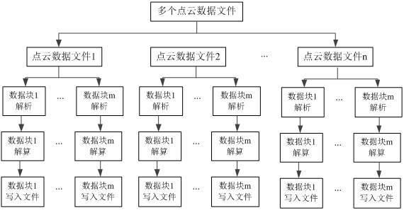
[0052] Specifically, combine figure 1 and figure 2, when the lidar collects data, it usually saves the collected data ...


PUM


Abstract

The invention discloses a laser radar point cloud data resolving method for resolving laser radar point cloud data, which comprises the following steps of: establishing a plurality of threads according to the number of point cloud data files acquired by a laser radar, and distributing at least one point cloud data file to each thread; enabling the plurality of threads to process the point cloud data file in parallel; wherein each thread adopts an assembly line mode to carry out parallel calculation processing on a plurality of data blocks in the point cloud data file, so that the calculation speed of the point cloud data file is greatly improved, the calculation time is saved, and a common processor can independently complete calculation without depending on other hardware. On the basis, the invention further provides a resolving device and a multi-thread processing system for the laser radar point cloud data.

Description

technical field [0001] The invention relates to the technical field of laser radar detection, in particular to a method, device and multi-thread processing system for solving laser radar point cloud data. Background technique [0002] Airborne laser scanning (Light Detection And Ranging, LIDAR) technology emerged in the late 1990s. It uses laser ranging and Global Positioning System (Global Positioning System, GPS) positioning principles to quickly obtain high-precision three-dimensional Coordinate points. [0003] At present, a type of laser scanner is usually mounted on a carrier platform such as airborne / vehicle / drone, and the raw data obtained by this type of laser scanner is the laser scanning reference coordinate system (scanner's own coordinate system, SOCS) Based on the point cloud data below, and then based on the calculation algorithm that matches this type of laser scanner combined with the POS (position and attitude) data provided by the integrated navigation de...

Claims


Application Information

Patent Timeline
Patent Type & Authority Patents(China)
IPC IPC(8): G06F9/50G01S17/89
CPCG01S17/89G06F9/5027
Inventor 陈婷婷其他发明人请求不公开姓名
Owner BEIJING GREEN VALLEY TECH CO LTD
Why Eureka
Try Eureka