Method for quickly positioning data in visualization interface of ocean spatio-temporal data

A technology of spatio-temporal data and positioning data, applied in the direction of electrical digital data processing, special data processing applications, instruments, etc., can solve problems such as waste of operating resources, slow query speed, unfavorable and accurate positioning of designated data, etc., to optimize user experience, The effect of reducing feedback time

Inactive Publication Date: 2018-12-07
TIANJIN UNIV
View PDF3 Cites 2 Cited by
  • Summary
  • Abstract
  • Description
  • Claims
  • Application Information

AI Technical Summary

Problems solved by technology

This method of querying data has the following disadvantages: (1) This query method has certain advantages in the query of small data volumes. When the data volume becomes larger, the query speed tends to be significantly slower and inefficient, and cannot meet the requirements of batching. inquiry request
(2) It is not conducive to accurately locate the specified data required by the operator
(3) Waste local operating resources
However, the research on the data processing system of marine meteorological survey is not perfect at home and abroad. In addition to the requirement of visual processing of massive data, a set of high-efficiency, accurate, low-latency query scheme and its data processing system have become the hot and difficult points of current research.

Method used


Image

  • Method for quickly positioning data in visualization interface of ocean spatio-temporal data
  • Method for quickly positioning data in visualization interface of ocean spatio-temporal data
  • Method for quickly positioning data in visualization interface of ocean spatio-temporal data

Examples


Embodiment Construction

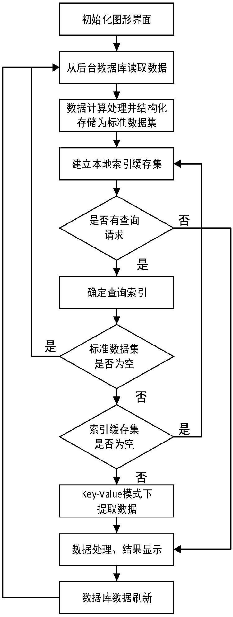
[0021] The purpose of the present invention is to overcome the above-mentioned deficiencies of the existing query methods, simulate the high efficiency of data access combined with distributed data storage, and fully examine the improved methods of the query methods on this basis. The method of quickly locating data on the ocean spatio-temporal data visualization interface, specifically, is to simulate the idea of ​​distributed storage, "classify" and store the local data, and then query the designated data in batches in the classified data according to the designated "index". Data, which in turn makes data query more efficient and accurate, reduces the feedback time of data query, improves scalability, and optimizes the user experience of the visual interface. Specific steps are as follows:

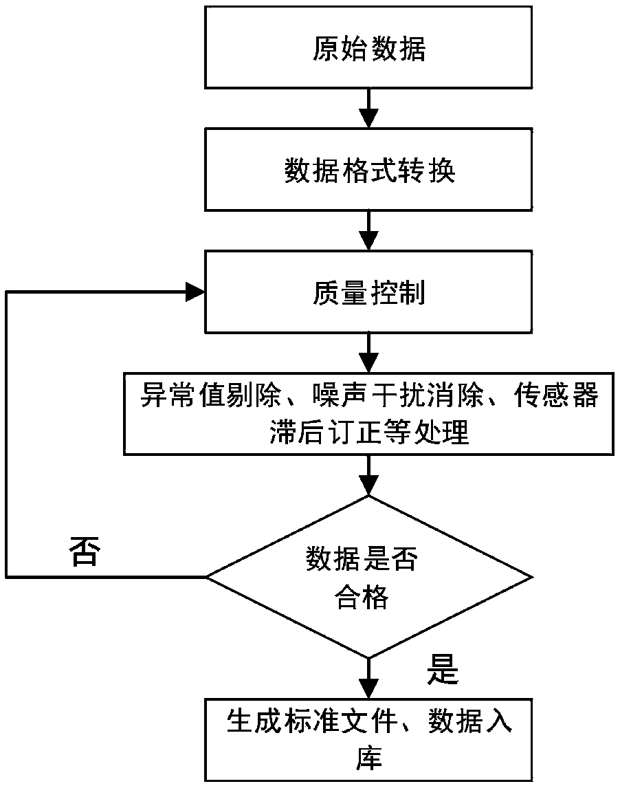
[0022] 1. Data quality control and preprocessing

[0023] Data quality control and preprocessing modules should be included before data storage, specifically,

[0024] Step 1: convert ...


PUM


Abstract

The invention relates to a method for quickly positioning data in a visualization interface of ocean spatio-temporal data. The method comprises the following steps: pre-processing data of a wind profiler and storing the processed data in a database; reading data from the database, and storing the data structurally and locally; visualizing spatio-temporal data with a cartographic tool; establishinga local index cache set, storing a spatial dimension index field in the standard data set in a "re-classification" manner according to possible indexes to be inquired, and establishing a mapping relationship between the indexes and data to be retrieved; and receiving a query request from the visualization interface, and transforming the query request into a query index of a preset format.

Description

technical field [0001] A method for quickly locating data on the ocean spatio-temporal data visualization interface. Background technique [0002] In the context of the era of big data, the data in various production fields is increasing massively, especially in the field of marine hydrology and meteorology. In the face of these massive data, it is first necessary to carry out standardized processing and storage, and then in a specific environment, these data need to be displayed intuitively and visually, which can effectively present the important characteristics of the data, reveal the objective laws, and improve the efficiency of scientific research and development. Improvement, etc. are of great significance. In this way, it is necessary to find a fast and efficient data query method during the research and development process, so that the visual experience can be effectively improved, and data editing can be smoother and faster. In the past research and development te...

Claims


Application Information

Patent Timeline
Patent Type & Authority Applications(China)
IPC IPC(8): G06F17/30
Inventor 杨嘉琛李国君
Owner TIANJIN UNIV
Why Eureka
Try Eureka