A road and building simulation modeling method based on real road surface data

A technology of simulation modeling and simulation model, which is applied in 3D modeling, image data processing, electrical digital data processing and other directions to improve the degree of simulation and complete the road model.

Active Publication Date: 2018-12-11
广东星舆科技有限公司
View PDF5 Cites 16 Cited by
  • Summary
  • Abstract
  • Description
  • Claims
  • Application Information

AI Technical Summary

Problems solved by technology

[0007] In view of the above problems, the present invention aims to provide a road and building simulation modeling method based

Method used


Image

  • A road and building simulation modeling method based on real road surface data
  • A road and building simulation modeling method based on real road surface data
  • A road and building simulation modeling method based on real road surface data

Examples


Embodiment Construction

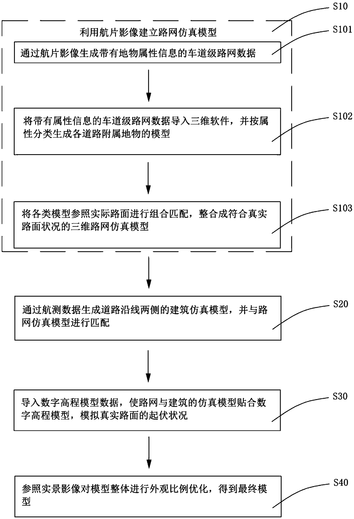
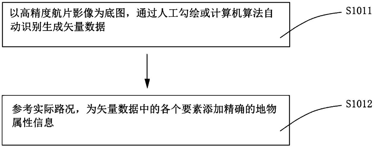
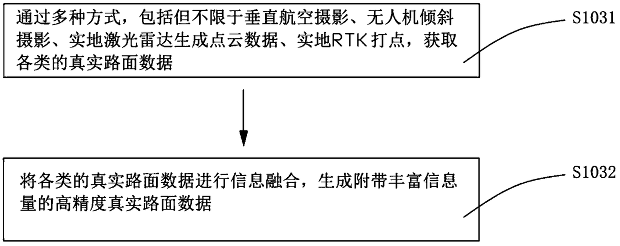
[0041] The technical solutions in the embodiments of the present invention will be clearly and completely described below in conjunction with the accompanying drawings in the embodiments of the present invention. Obviously, the described embodiments are only part of the embodiments of the present invention, not all of them. . Based on the embodiments of the present invention, all other embodiments obtained by persons of ordinary skill in the art without creative efforts fall within the protection scope of the present invention.

[0042] It should be noted that the terms used in the embodiments of the present invention are only for the purpose of describing specific embodiments, and are not intended to limit the present invention. As used in the embodiments of the present invention and the appended claims, the singular forms "a", "said" and "the" are also intended to include the plural forms unless the context clearly indicates otherwise. It should also be understood that the ...


PUM


Abstract

The invention provides a road and building simulation modeling method based on real road surface data, the method comprising the following steps: S10, establishing a road network simulation model by using aerial photograph images; S20, generating building simulation models along the road by aerial survey data, and matching the building simulation models with the road network simulation models; S30, importing the digital elevation model data, so that the simulation model of the road network and the building conforms to the digital elevation model, and simulating the undulation condition of thereal pavement; S40, optimizing the overall appearance ratio of the model with reference to the real image to obtain the final model. According to the idea that the model attribute information groupware is modeled and matched with the space, by means of multi-source data fusion, the road model and the building model along the road are combined and matched with reference to the actual pavement, so that the model can show more details of the pavement, can restore the shape of the real street scene, undulation and other details, and can be better used in driving perspective simulation and other application scenes.

Description

【Technical field】 [0001] The invention relates to the technical field of road three-dimensional modeling, in particular to a road and building simulation modeling method based on real road surface data. 【Background technique】 [0002] The lane-level high-precision electronic map is a sub-meter-level precision map that mainly serves unmanned vehicles, or machine drivers. Compared with traditional navigation maps, high-precision electronic maps have higher real-time performance, accuracy in representing road surface features, and richness of semantic information. After obtaining the lane-level high-precision electronic map data, the driverless car can use high-precision positioning to match itself to the electronic map road network in real time. Real-time comparison enables route planning and avoidance of other traffic participants on the road. It enables unmanned vehicles to reduce their dependence on the on-board high-precision perception system, and is an essential part o...

Claims


Application Information

Patent Timeline
IPC IPC(8): G06T17/00G06F17/50
CPCG06T17/00G06F30/18Y02T10/40
Inventor 刘振宇颉刚李昱吴金恒
Owner 广东星舆科技有限公司
Why Eureka
Try Eureka