Intersection-oriented intelligent local dynamic map implementation system and implementation method thereof

A dynamic map and system realization technology, applied in the field of intelligent transportation, can solve the problems of traffic accidents, inattentive observation and avoidance, rear-end collision accidents, etc., and achieve the effect of reducing the accident rate, reducing congestion and high practicability.

Inactive Publication Date: 2018-12-11
TONGJI UNIV
View PDF14 Cites 17 Cited by
  • Summary
  • Abstract
  • Description
  • Claims
  • Application Information

AI Technical Summary

Problems solved by technology

First, at the intersection controlled by traffic lights, some drivers think that the yellow light is a prelude to turning into a red light, and it is a signal to pass the intersection legally and quickly. At the stop line, the yellow light turns into a red light again. At this time, they are busy with emergency braking or slowing down to stop in a hurry, which makes the vehicles behind them unprepared, resulting in a rear-end collision accident; some drivers see that the yellow light has turned into a red light. If the vehicle is already approaching the stop line at the intersection, just run through the red light directly, and there is a high possibility of a traffic accident
Second, when the straight-going vehicle is released, the left-turning vehicle on the opposite side, the straight-going vehicle on the transverse lane, and the left-turning vehicle may run a red light at any time. If you do not pay attention to observation and avoidance, a collision may occur; some pedestrians, cyclists , pass through the red light signal as usual, and walk through the traffic flow, if the driver cannot see or is not focused, he may collide with it
Fourth, when the left-turning green light is on, left-turning vehicles are allowed to pass, but at this time there are still some pedestrians and bicycles passing on the zebra crossing of the pedestrian crossing, and straight-going vehicles that have exceeded the stop line on the transverse road are also passing. When turning left, vehicles may collide with them if they do not pay attention to observation and avoidance; when vehicles are turning left, vehicles behind often violate the rules and suddenly forcibly pass quickly from the rear side. The range of viewing angle becomes smaller, forming a partial line of sight "blind zone"
However, the traffic department has equipment such as cameras and microwave radars for such locations, but such equipment is limited to accident recording purposes

Method used


Image

  • Intersection-oriented intelligent local dynamic map implementation system and implementation method thereof
  • Intersection-oriented intelligent local dynamic map implementation system and implementation method thereof
  • Intersection-oriented intelligent local dynamic map implementation system and implementation method thereof

Examples


Embodiment

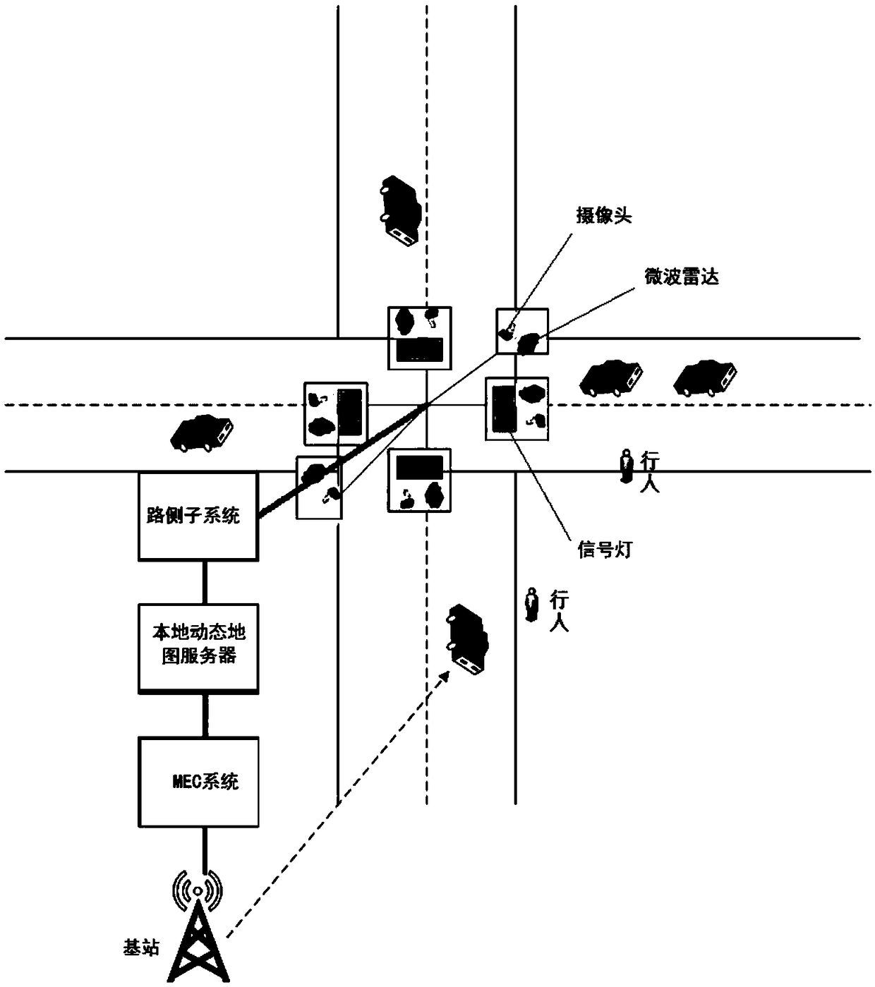
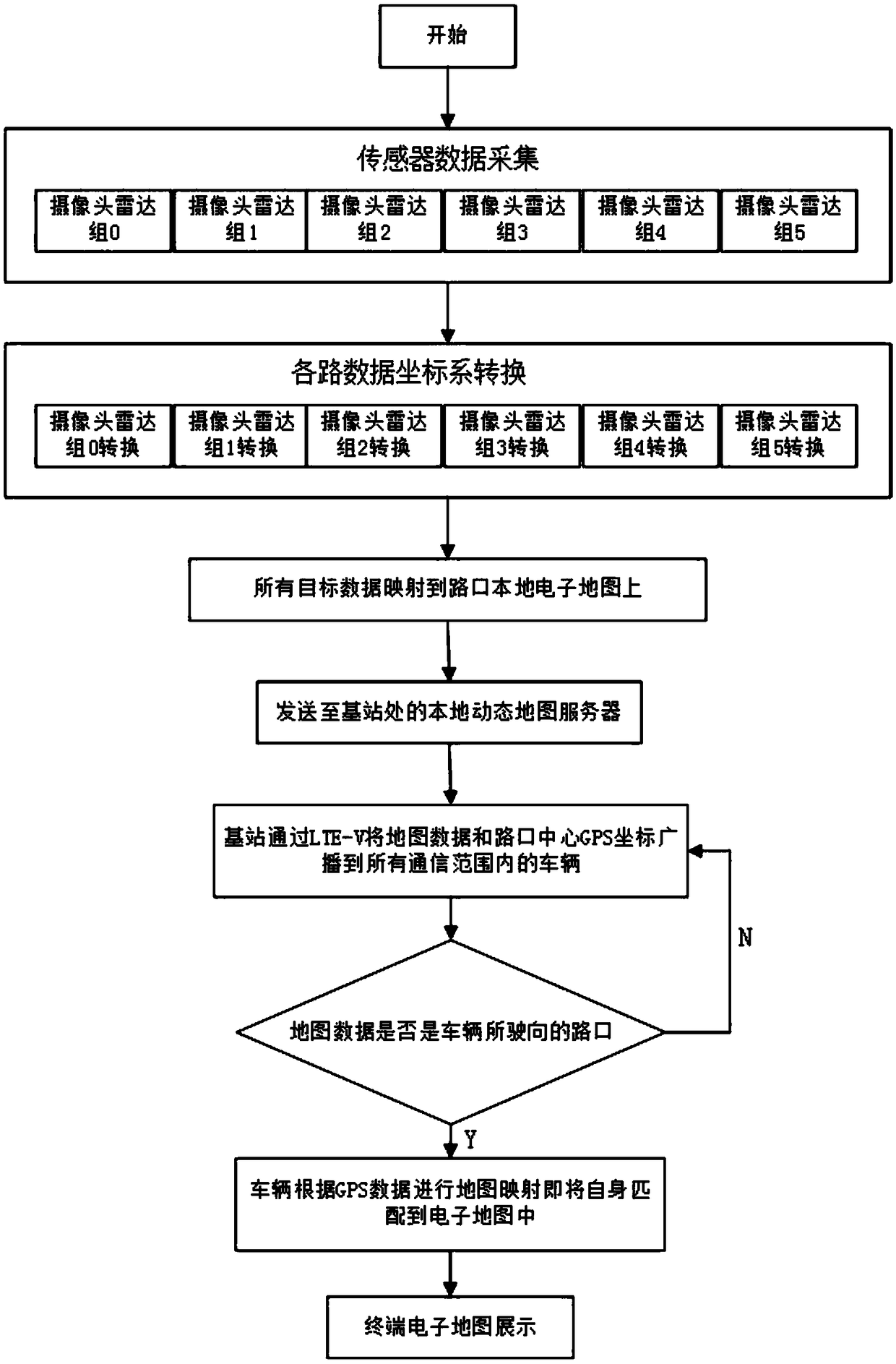
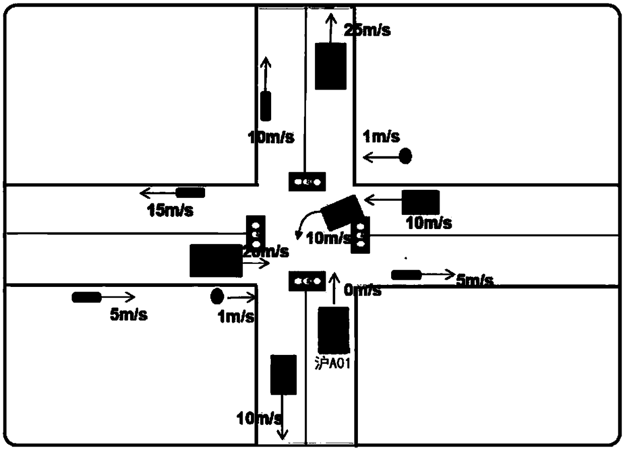
[0037] Such as figure 1 As shown, an intersection-oriented intelligent local dynamic map implementation system includes a vehicle terminal system installed on a vehicle and a roadside subsystem installed at an intersection. Among them, the MEC system uses Mobile / Multi-Access Edge Computing (MEC) technology, which migrates computing storage capabilities and business service capabilities to the edge of the network, enabling applications, services, and content to be localized, Close-distance and distributed deployment can solve the business needs of technical scenarios such as high-capacity network hotspots, large connections with low power consumption, and low latency and high reliability to a certain extent. At the same time, by fully mining mobile network data and information, MEC realizes the perception and analysis of mobile network context information and opens it to intelligent driving business applications, effectively improving the intelligence level of mobile networks a...


PUM


Abstract

The invention relates to an intersection-oriented intelligent local dynamic map implementation system and an implementation method thereof. The system comprises a vehicle end subsystem disposed on a vehicle and a roadside subsystem disposed at an intersection. The vehicle end subsystem comprises a vehicle-borne industrial control computer and also comprises a first Internet of vehicles communication module, a GPS module and a display connected to the vehicle-borne industrial control computer. The roadside subsystem comprises a roadside industrial control computer and also comprises a second Internet of vehicles communication module connected to the roadside industrial control computer. The roadside industrial control computer is connected to a traffic signal lamp, a plurality of cameras and a plurality of microwave radars. The first Internet of vehicles communication module and the second Internet of vehicles communication module are in a communication connection through a base station. Compared with the prior art, a driver can know a traffic situation near an intersection such that the driver can find possible dangers in the vicinity as early as possible, the accident rate can bereduced to some extent, in addition, the driver can known traffic congestion information of a front road in advance and dynamically adjust a route, and traffic congestion is reduced.

Description

technical field [0001] The invention relates to the technical field of intelligent transportation in the Internet of Vehicles, in particular to an intersection-oriented intelligent local dynamic map realization system and a realization method. Background technique [0002] The Internet of Vehicles refers to the realization of information sharing of state information (including attribute information, static and dynamic information, etc.) and road traffic environment information (including road infrastructure information, traffic conditions, service information, etc.) of all vehicles through a variety of wireless communication technologies. , and provide effective supervision and comprehensive services to the motion states of all vehicles according to different functional requirements. The Internet of Vehicles can realize information interaction between vehicles, vehicles and roads, and vehicles and people. Just like the Internet connects every single computer, the Internet o...

Claims


Application Information

Patent Timeline
IPC IPC(8): G08G1/0969G08G1/0968G08G1/01
CPCG08G1/012G08G1/0968G08G1/0969
Inventor 王平刘富强王新红周宇
Owner TONGJI UNIV
Why Eureka
Try Eureka