Simultaneous localization and mapping (SLAM) method for unmanned aerial vehicle based on mixed vision odometers and multi-scale map

A visual odometry, UAV technology, applied in navigation calculation tools, measuring devices, instruments, etc., can solve the problem that the feature point method and the direct method can not well adapt to the positioning requirements of the UAV, and are not suitable

Active Publication Date: 2018-12-18
NANJING UNIV OF AERONAUTICS & ASTRONAUTICS
View PDF7 Cites 59 Cited by
  • Summary
  • Abstract
  • Description
  • Claims
  • Application Information

AI Technical Summary

Problems solved by technology

[0004] Considering that UAVs have relatively high requirements for stability, real-time, and accuracy, neither the traditional feature point method nor the direct method can well meet the positioning requirements of UAVs. It is necessary to...

Method used


Image

  • Simultaneous localization and mapping (SLAM) method for unmanned aerial vehicle based on mixed vision odometers and multi-scale map
  • Simultaneous localization and mapping (SLAM) method for unmanned aerial vehicle based on mixed vision odometers and multi-scale map
  • Simultaneous localization and mapping (SLAM) method for unmanned aerial vehicle based on mixed vision odometers and multi-scale map

Examples


Embodiment Construction

[0058] The present invention will be described in detail below in conjunction with the accompanying drawings.

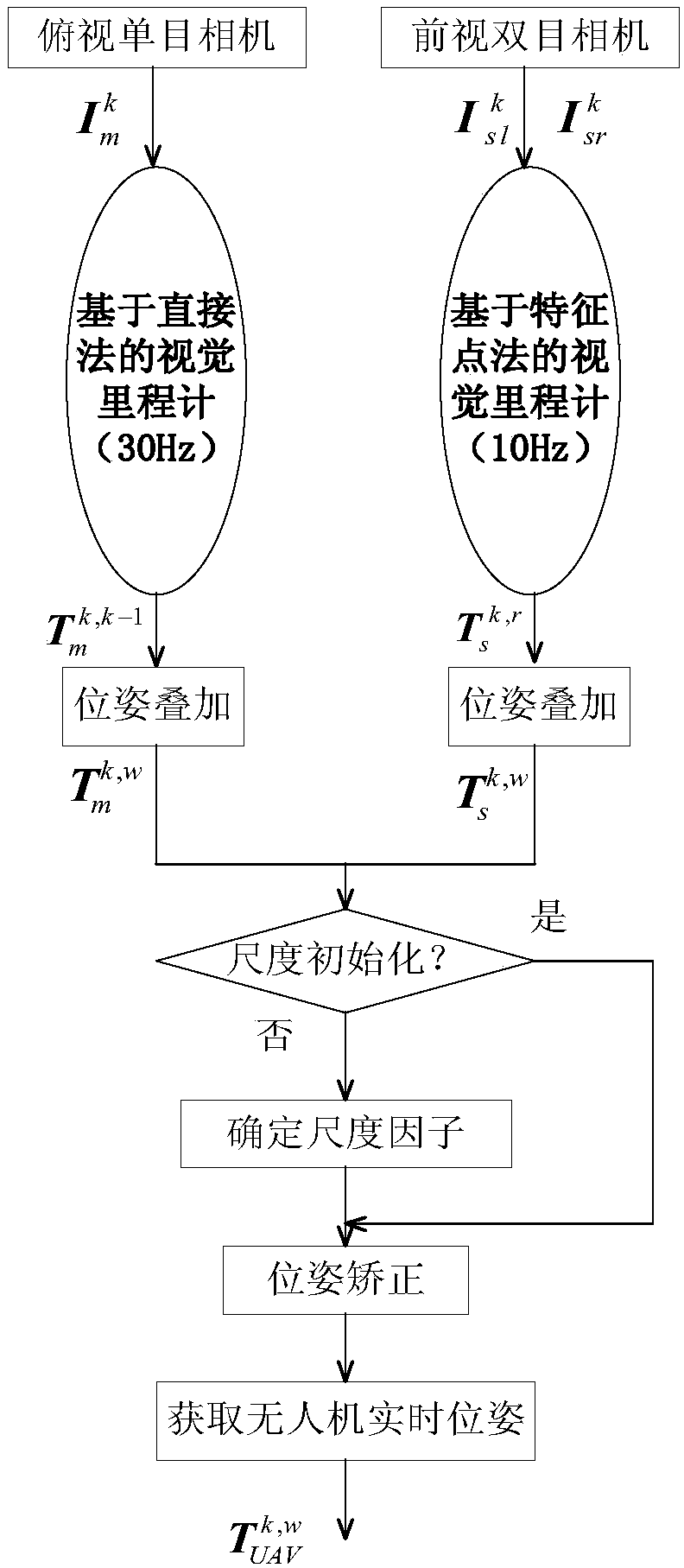
[0059] figure 1 It is a system block diagram of the hybrid visual odometer of the present invention, and the hybrid visual odometer includes two threads of a monocular visual odometer based on a direct method and a binocular visual odometer based on a feature point method. The UAV platform is equipped with a top-down monocular camera and a forward-looking binocular camera. The monocular camera collects 30 frames of images per second, and the binocular camera collects 10 frames of images per second. The onboard computer starts two threads at the same time, the main thread runs the visual odometry based on the direct method at a frequency of 30Hz, and the other thread runs the visual odometry based on the feature point method at a frequency of 10Hz. If the synchronized monocular camera image is acquired at time k Images corresponding to the left and right cameras o...


PUM


Abstract

The invention discloses a simultaneous localization and mapping (SLAM) method for an unmanned aerial vehicle based on mixed vision odometers and a multi-scale map, and belongs to the technical field of autonomous navigation of unmanned aerial vehicles. According to the SLAM method, an overlooking monocular camera, a foresight binocular camera and an airborne computer are carried on an unmanned aerial vehicle platform; the monocular camera is used for the visual odometer based on a direct method, and binocular camera is used for the visual odometer based on feature point method; the mixed visual odometers conduct information fusion on output of the two visual odometers to construct the local map for positioning, and the real-time posture of the unmanned aerial vehicle is obtained; then theposture is fed back to a flight control system to control the position of the unmanned aerial vehicle; and the airborne computer transmits the real-time posture and collected images to a ground station, the ground station plans the flight path in real time according to the constructed global map and sends waypoint information to the unmanned aerial vehicle, and thus autonomous flight of the unmanned aerial vehicle is achieved. Real-time posture estimation and environmental perception of the unmanned aerial vehicle under the non-GPS environment are achieved, and the intelligent level of the unmanned aerial vehicle is greatly increased.

Description

technical field [0001] The invention relates to a SLAM method for an unmanned aerial vehicle based on a hybrid visual odometer and a multi-scale map, and belongs to the technical field of autonomous navigation of an unmanned aerial vehicle. Background technique [0002] With the development of UAV (Unmanned Aerial Vehicle, UAV) technology, various types of UAVs have been widely used, and UAVs have begun to play an increasingly important role in the industrial field, and UAVs are no longer It is a simple aircraft model aircraft. How to perceive the environment and its own state information has become one of the key technologies of UAVs, which is the problem of simultaneous localization and mapping (SLAM) in the field of robotics. [0003] Compared with ground mobile robots, UAVs have limited payload and have high requirements for real-time performance. Traditional lidar sensors are not suitable for UAV platforms due to their heavy weight and susceptibility to light effects....

Claims


Application Information

Patent Timeline
IPC IPC(8): G01C21/00G01C21/20
CPCG01C21/005G01C21/20
Inventor 刘阳王从庆李翰
Owner NANJING UNIV OF AERONAUTICS & ASTRONAUTICS
Why Eureka
Try Eureka